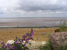
The Wash
Coordinates: 52 ° 55 ′ 44 ″ N , 0 ° 19 ′ 7 ″ E
The Wash is an estuary formed by the mouths of the Witham ("The Haven"), Welland , Nene and Great Ouse rivers . It is located on the East or North Sea coast of England at about 53 ° north latitude and 0-1 ° east longitude.
geography
The estuary forms a wide indentation on the east coast of England. This consists of three coastal strips, each about 25 kilometers in length. The east bank of the estuary is in the county of Norfolk . It extends from Hunstanton in the north to the mouth of the Great Ouse at King's Lynn in the south. The opposite bank area extends from Gibraltar Point near Skegness to the mouth of the Welland . In the connecting south-western section of the bank, the Nene flows into the estuary as the third river halfway along . The latter two bank areas together form the coastal zone of the county of Lincolnshire . The estuary has formed an extensive area of the Wadden Sea , especially along the southwestern shoreline - here large areas of sandbanks surface daily due to the tides of the North Sea. Therefore, this area, comparable to the wadden area of the Outer Elbe , is extremely difficult for the incoming and outgoing ships. For example, a lightship shows the way into the Lynn Channel, which safely brings ships from the open sea to the south coast of the estuary.
The adjacent hinterland forms a marshland landscape . This was by draining u. a. opened up for settlement and agriculture by Cornelius Vermuyden over the course of several centuries. This area is called " The Fens " (the swamps). Due to the early sedimentation and artificial land reclamation, some cities that used to be directly on the sea have now moved inland.
Wildlife
The area is subject to the EU's Birds Directive . There are extensive salt marshes , larger sandbanks at low tide, shallow water points and deep channels. At Freiston a dyke was broken in three places in order to enlarge the salt marshes and thus to offer a larger habitat for rare birds. The extensive bays and the vegetation that grows here contribute to the fact that the energy of the waves is reduced. This is an example of the opportunities for sustainable coastal zone management that are currently developing .
On the east side of the estuary there are low limestone cliffs with layers of the well-known red limestone and gravel pits, which are necessary as breeding grounds for birds when the water level is high.
Legend
According to legend, King Johann Ohneland is said to have lost the English crown jewels of that time, which resulted in the play on words “King John lost his clothes in the wash” (“King John lost his clothes in the wash”).


