Drift the
|
Driftsethe
Driftseth ( Low German ) |
||
|---|---|---|
| Coordinates: 53 ° 22 ′ 44 ″ N , 8 ° 37 ′ 9 ″ E | ||
| Height : | 0 m above sea level NHN | |
| Area : | 15.37 km² | |
| Residents : | 701 (Nov. 27, 2017) | |
| Population density : | 46 inhabitants / km² | |
| Incorporation : | 1st of January 2014 | |
| Postal code : | 27628 | |
| Area code : | 04746 | |
|
Location of Driftsethe in Lower Saxony |
||
|
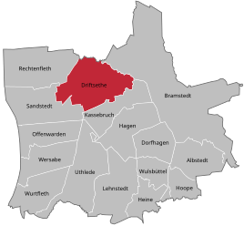
Driftsethe in the municipality of Hagen in Bremen
|
||
Driftsethe ( Low German Driftseth ) is a village in the unitary community of Hagen in Bremen in the Lower Saxony district of Cuxhaven .
geography
location
Driftsethe is located east of the A 27 federal motorway between Bremen and Bremerhaven and north of Hagen in the Bremen region .
The place lies on the northern edge of the Geestinsel, which begins south of Uthlede. It was once bounded to the west by an arm of the Weser and to the north and east by the lowlands of the Drepte River . Therefore, the area is characterized by geest , fields in the south and around the place and by moor, pastures and meadows in the east, north and west.
Local division
- Driftsethe village center ( Haufendorf )
- Tannendorf (settlement, 2 km east)
- Weißenberg (settlement, 2 km west)
Neighboring places
| Rechtenfleth |
Stotel ( Loxstedt single community ) |
Bramstedt |

|
||
| Sandstedt | Cash breakage |
(Source:)
history
Foundation and name
Driftsethe is mentioned for the first time in a document from Archbishop Friedrich I of Bremen from 1105 about the extent of the Obedience Bramstedt as "dreptisati".
The place name probably means "Those sitting on the Drepte", whereby the Drepte is a tributary of the Weser, which limits the community to the east, behind Tannendorf.
The place name is said to be of Chauky origin.
Early archaeological finds
Early archaeological finds indicate a long history as a settlement area: According to ancient counts, 21 burial mounds are said to have existed around Driftsethe. They can be attributed to the younger Stone Age. However, none could be properly explored. Probably the last stone grave was found by chance at the end of the 1890s “next to the Seedorf (now Dietrich) farm in Ackerfelde, deep below the surface”. While cultivating the heather, southwest of the village, an urn cemetery was discovered in 1882/1883, but no detailed investigation was carried out. However, later urn finds when driving sand on the Weißenberg allow the conclusion that a date can be made in the early Germanic-Saxon period. The place can be found for the first time in records of the Bremen Church.
Incorporations
On January 1, 2014, the joint community of Hagen and its member communities were dissolved and the new community of Hagen in Bremen was established.
Population development
|
|
¹ as of December 31
² according to the info box

|
politics
Local council
The local council of Driftsethe consists of seven councilors from the following parties:
- WG constituency : 4 seats
- CDU : 2 seats
- SPD : 1 seat
(Status: local election September 11, 2016)
Local mayor
The local mayor of Driftsethe is Heiner Schöne (WG voter community).
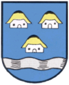
coat of arms
The design of the municipal coat of arms of Driftsethe comes from the heraldist and coat of arms painter Albert de Badrihaye , who designed around 80 coats of arms in the Cuxhaven district.
| Blazon : "In blue over a silver wavy bar in the base of the shield, three (2: 1) silver peasant cottages with a golden roof." | |
| Foundation of the coat of arms: The village is mentioned in a document as early as 1105 as "Dreptisati". The farmer's cottages above a wavy bar indicate the interpretation of the name as a settlement on the Drepte. |
Culture and sights
Buildings
Maple Avenue
Over a century ago was a sycamore -Allee (1904) by Carl Arend Ficke, the former owner of the farm and house Wittenborgh planted by the White Mountain. It is still the private route to this property today. The avenue consists of over a hundred trees and is around 500 meters long.
By ordinance of the district of Cuxhaven of December 17, 2008, this maple avenue was declared a protected part of the landscape.
Barrows
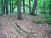
At Weißenberg there is a group of three barrows and a larger single grave. These probably come from the Middle Bronze Age and are therefore approx. 3000 to 4000 years old. These are probably the last surviving barrows in a group of 25, in some cases very large, hills. These are of particular cultural and historical importance because they are the last surviving example of the erection of burial mounds on the heather on the edge of the marshland in this area. In the middle of such tumuli there is often a wreath made of larger stones in which the urn and, if necessary, accessories were placed. At the end of the 19th century, a bronze sword was found in a barrow east of Kassebruch.
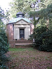
Illjes mausoleum on Weißenberg
The mausoleum of the Illjes family was built on Weißenberg after the death of Jacob Illjes in 1854. Jakob Illjes originally came from Sandstedt from a large marshland and after an unfortunate love story with a distant relative of the march poet Hermann Allmers moved to the wasteland on the Weißenberg. There he founded the farm "Wittenborgh". He died at the age of 40. It was his last will to be buried on the Weißenberg with a view towards Sandstedt. His parents therefore had the mausoleum built, in which they themselves were later buried.
mausoleum
Behind the cemetery in Driftsethe you can find the listed mausoleum. It was about. Built in 1889 by the Ficke family and is now owned by the von Wurmb family, descendants of the Ficke family.
Nature reserves
The 140 hectare LU 118 Bargsmoor / Rechtenflethermoor nature reserve and the CUX 39 nature reserve have existed in Driftsethe since 1985. As early as 1938, the 21 ha “wood on the White Mountains” was declared a CUX 39 landscape protection area by the Wesermünde administrative district. There used to be a ground covered with heather, which is now overgrown with trees appropriate to the location.
societies
- Fishing club
- Driftsether sports club
- Driving and riding club
- Volunteer firefighter
- Rural youth
- Shooting club
- marching band
traffic
In the west, Driftsethe has a direct connection to the A 27 Bremen – Bremerhaven motorway via the Hagen junction. Via the “Schnellferry Sandstedt – Brake” and the Weser tunnel near Dedesdorf, there is also access to Nordenham .
At a distance of approx. 16 km in Stubben you will find the next railway with the route Bremen – Bremerhaven - Cuxhaven .
Sons and daughters of the place
- Diedrich Steilen (1880–1961), educator, local researcher and co-founder of the Vegesack and Surroundings Local History Association
Myths and legends
There used to be a castle on Weissenberg, with a capricious and hard-hearted mistress who was only concerned with her own well-being. One day the kitchen maid suffered a great mishap. While cleaning, she dropped one of the silver cups into the well and weeping told her mistress of her misfortune. But unmoved, she asked the maid to get the cup back. In her distress, she climbed into the well and drowned. And since then, every year on the day of her death, a white female figure looking for the mug has appeared here. Soon afterwards the lady of the castle also died and was buried in the family crypt there. When the crypt was opened years later, only a heart-shaped stone was found, which has been called the heart stone ever since.
literature
- Fritz Hörmann, Ude Meyer, Christian Morisse, Eberhard Nehring, Irmgard Seghorn, Egon Stuve, Else Syassen: Wesermünde field names collection - the field names of the property tax cadastre from 1876 . Ed .: Kulturstiftung der Kreissparkasse Wesermünde (= new series of special publications by the men from Morgenstern , Heimatbund an Elb- und Wesermuende eV Volume 27 ). Men from Morgenstern Verlag, Bremerhaven 1995, ISBN 3-931771-27-X , p. 7 ([ digitized version ( memento from October 26, 2007 in the Internet Archive )] [PDF; 431 kB ; accessed on October 23, 2019]).
Web links
Individual evidence
- ↑ a b municipalities in Germany by area, population and postcode. (XLS; 4.9 MB) See under: Lower Saxony, No. 2013 . In: Destatis website. Federal Statistical Office, December 31, 2013, accessed on November 13, 2019 .
- ↑ Overview map of the Cuxhaven district. In: cuxland-gis.landkreis-cuxhaven.de. November 2016, accessed December 11, 2019 .
- ↑ Law on the reorganization of the municipality of Hagen in the Bremen district of Cuxhaven . In: Niedersächsische Staatskanzlei (Ed.): Niedersächsisches Gesetz- und Verordnungsblatt (Nds. GVBl.) . No. 10/2013 . Hanover June 19, 2013, p. 162 , p. 6 ( digitized version ( memento from September 26, 2018 in the Internet Archive ) [PDF; 153 kB ; accessed on May 24, 2019]).
- ↑ Ulrich Schubert: Community directory Germany 1900 - Geestemünde district. Information from December 1, 1910. In: gemeindeververzeichnis.de. January 5, 2020, accessed January 18, 2020 .
- ↑ a b c Michael Rademacher: German administrative history from the unification of the empire in 1871 to the reunification in 1990. Wesermünde district ( see under: No. 20 ). (Online material for the dissertation, Osnabrück 2006).
- ↑ a b Statistisches Bundesamt Wiesbaden (ed.): Official municipality register for the Federal Republic of Germany - 1957 edition (population and territorial status September 25, 1956, for Saarland December 31, 1956) . W. Kohlhammer, Stuttgart 1958, p. 192 ( digitized version ).
- ↑ Lower Saxony State Administration Office (ed.): Municipal directory for Lower Saxony . Municipalities and municipality-free areas. Self-published, Hanover January 1, 1973, p. 47 , Wesermünde district ( digitized version ( memento from August 7, 2019 in the Internet Archive ) [PDF; 21.3 MB ; accessed on June 3, 2020]).
- ^ Municipalities in Germany by area and population. (XLSX; 895 kB) See under: Lower Saxony, No. 1913 . In: Destatis website. Federal Statistical Office, December 31, 1975, accessed on June 11, 2019 .
- ↑ a b c d e f g municipality directory - archive - regional structure - annual editions - Lower Saxony. (All politically independent municipalities in EXCEL format). In: Destatis website. Federal Statistical Office, accessed on November 13, 2019 .
- ^ Local council Driftsethe. In: pvrat.de. Retrieved November 13, 2019 .
- ↑ a b The local council of Driftsethe. In: driftsethe.de. Retrieved September 5, 2017 .
- ↑ Archive - Catalog 1 - Germanic Mythology, Prehistory and Runes. In: Website Versandantiquariat Hans-Jürgen Lange. Retrieved on November 29, 2017 (see under: No. 162 - Koerner, Dr. jur. Bernhard).
- ↑ a b Landkreis Wesermünde (Ed.): Coat of arms of the Landkreis Wesermünde . Grassé Offset Verlag, Bremerhaven / Wesermünde 1973, ISBN 3-9800318-0-2 .
- ↑ The Driftsether coat of arms. In: driftsethe.de. Retrieved March 2, 2017 .
- ^ Official journal for the district of Cuxhaven, No. 2, 33rd year. (PDF; 1.2 MB) Ordinance of the district of Cuxhaven on the protected landscape component in the joint municipality of Hagen of December 17, 2008, LB-CUX 51 (under No. 23). In: Website of the district of Cuxhaven. District of Cuxhaven, January 15, 2009, pp. 1–4 , accessed on May 24, 2019 .


