Offenwarden (Hagen in Bremen)
|
Disclosure
|
||
|---|---|---|
| Coordinates: 53 ° 20 ′ 13 ″ N , 8 ° 31 ′ 51 ″ E | ||
| Height : | 0 m above sea level NHN | |
| Area : | 8.49 km² | |
| Residents : | 175 (Nov. 27, 2017) | |
| Population density : | 21 inhabitants / km² | |
| Incorporation : | July 1, 1968 | |
| Incorporated into: | Sandstedt | |
| Postal code : | 27628 | |
| Primaries : | 04702, 04746 | |
|
Location of Offenwarden in Lower Saxony |
||
|
Offenwarden in the municipality of Hagen in Bremen
|
||
Offenwarden ( Low German Offenwarden ) is a district of the unitary community of Hagen in Bremen in the Lower Saxony district of Cuxhaven .
geography
| Sandstedt | Cash breakage | |

|
Uthlede | |
| Wersabe |
(Source:)
history
Incorporations
On July 1, 1968, the previous political independence of the municipality of Offenwarden ended because the place merged with other municipalities to form the new municipality of Sandstedt , which in turn became a member municipality of the integrated municipality of Hagen for the territorial reform in Lower Saxony , which took place on March 1, 1974 .
On January 1, 2014, the joint community of Hagen and its member communities were dissolved and the new community of Hagen in Bremen was established .
Population development
| year | 1910 | 1925 | 1933 | 1939 | 1950 | 1956 | 2017 |
|---|---|---|---|---|---|---|---|
| Residents | 359 | 367 | 325 | 299 | 444 | 348 | 175 ¹ |
| source |
¹ according to the info box

|
politics
City council and mayor
At the communal level, Offenwarden is represented by the council of the municipality of Hagen in Bremen.
Mayor
The mayor of Offenwarden is Harm von Hollen ( CDU ). The term of office runs from 2016 to 2021.
coat of arms
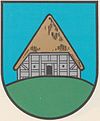
The design of the Offenwarden municipal coat of arms comes from the heraldist and coat of arms painter Albert de Badrihaye , who designed around 80 coats of arms in the Cuxhaven district.
| Blazon : "In blue on green Wurt a Lower Saxony farmhouse with silver half-timbered and golden thatched roof." | |
| Foundation of the coat of arms: The name "Uffenwurthe", which was mentioned in a document in 1105, was interpreted by Luneberg Mushard as "up the sausage". Therefore, the community chose a farmhouse on a Wurt as its coat of arms. |
Culture and sights
Buildings
- Villa Osterndorff with the Cafe Salon 1900
Web links
Individual evidence
- ↑ Overview map of the Cuxhaven district. In: cuxland-gis.landkreis-cuxhaven.de. November 2016, accessed April 29, 2020 .
- ^ Fritz Hörmann, Ude Meyer, Christian Morisse, Eberhard Nehring, Irmgard Seghorn, Egon Stuve, Else Syassen: Field names collection Wesermünde - The field names of the property tax cadastre from 1876 . Ed .: Kulturstiftung der Kreissparkasse Wesermünde (= new series of special publications by the men from Morgenstern , Heimatbund an Elb- und Wesermuende eV Volume 27 ). Men from Morgenstern Verlag, Bremerhaven 1995, ISBN 3-931771-27-X , p. 17 ([ digitized version ( memento of October 26, 2007 in the Internet Archive )] [PDF; 431 kB ; accessed on October 23, 2019]).
- ^ Federal Statistical Office (ed.): Historical municipality directory for the Federal Republic of Germany. Name, border and key number changes in municipalities, counties and administrative districts from May 27, 1970 to December 31, 1982 . W. Kohlhammer, Stuttgart / Mainz 1983, ISBN 3-17-003263-1 , p. 248 .
- ↑ Law on the reorganization of the municipality of Hagen in the Bremen district of Cuxhaven . In: Niedersächsische Staatskanzlei (Ed.): Niedersächsisches Gesetz- und Verordnungsblatt (Nds. GVBl.) . No. 10/2013 . Hanover June 19, 2013, p. 162 , p. 6 ( digital version [PDF; 153 kB ; accessed on May 28, 2019]).
- ↑ Ulrich Schubert: Community directory Germany 1900 - Geestemünde district. Information from December 1, 1910. In: gemeindeververzeichnis.de. January 5, 2020, accessed April 30, 2020 .
- ↑ a b c Michael Rademacher: German administrative history from the unification of the empire in 1871 to the reunification in 1990. Wesermünde district ( see under: No. 68 ). (Online material for the dissertation, Osnabrück 2006).
- ↑ a b Statistisches Bundesamt Wiesbaden (ed.): Official municipality register for the Federal Republic of Germany - 1957 edition (population and territorial status September 25, 1956, for Saarland December 31, 1956) . W. Kohlhammer, Stuttgart 1958, p. 192 ( digitized version ).
- ^ Head of Offenwarden. (No longer available online.) In: Website of the municipality of Hagen in Bremen. Archived from the original on June 17, 2019 ; accessed on April 29, 2020 .
- ↑ a b Landkreis Wesermünde (Ed.): Coat of arms of the Landkreis Wesermünde . Grassé Offset Verlag, Bremerhaven / Wesermünde 1973, ISBN 3-9800318-0-2 .
- ↑ Franky and Nancy Steklar: Cafe Salon 1900 in the Villa open Warden. In: Website Cafe Salon 1900. Accessed February 23, 2018 .


