
Harrendorf (Hagen in Bremen)
|
Harrendorf
Harrendkörper ( Low German ) |
||
|---|---|---|
 |
||
| Height : | 13 m above sea level NHN | |
| Area : | 11.51 km² | |
| Residents : | 308 (Jan 1, 1973) | |
| Population density : | 27 inhabitants / km² | |
| Incorporation : | March 1, 1974 | |
| Incorporated into: | Bramstedt | |
| Postal code : | 27628 | |
| Area code : | 04746 | |
Location of Harrendorf in Lower Saxony |
||

Harrendorf ( Low German Harrendkör ) is a district of the village of Bramstedt in the unified community of Hagen in the Bremen district of Cuxhaven in Lower Saxony .
geography
Local division
- Finna
- Finnaer Berg
- Harrendorf (core town)
Neighboring places
| Bramstedt | Bramstedt - Lohe district | |
.svg)
|
Axstedt ( Osterholz district ) |
|
| Dorfhagen | Wulsbüttel - Albstedt district |
Lübberstedt (district of Osterholz) Osterholz-Scharmbeck (district of Osterholz) |
(Source:)
history
Incorporations
The formerly independent municipality of Finna was incorporated into the municipality of Harrendorf on August 1, 1929.
The integrated community of Hagen was created on January 1, 1970 and initially comprised 16 communities with Harrendorf. According to § 7 of the law on the reorganization of the municipalities in the Bremervörde area of June 13, 1973 (Nds. GVBl. P. 183), the formerly independent municipality of Harrendorf became part of the municipality as part of the regional reform in Lower Saxony , which took place on March 1, 1974 Bramstedt incorporated.
In June 2013 it was decided to dissolve the joint municipality of Hagen on January 1, 2014 and to form the unitary municipality with the name Hagen in Bremen from its area.
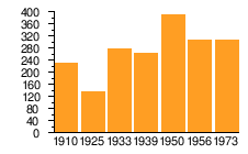
Population development
| year | 1910 | 1925 | 1933 | 1939 | 1950 | 1956 | 1973 |
|---|---|---|---|---|---|---|---|
| Residents | 231 ¹ | 138 ² | 278 | 264 | 392 | 309 | 308 |
| source | |||||||
¹ including Finna incorporated in 1929 (= 107 inhabitants)
² including Finna incorporated in 1929 (= no population information) included
|
politics
Local councilor and local mayor
Harrendorf is represented by the local council of the village of Bramstedt.
coat of arms
The design of the municipal coat of arms of Harrendorf comes from the heraldist and coat of arms painter Albert de Badrihaye , who designed around 80 coats of arms in the district of Cuxhaven.
|
|
Blazon : " Split , in front in green the golden head of a roebuck with a neck , behind in silver over a black hip horn with golden fittings and golden hanger two green fir trees ." |
| Justification of the coat of arms: The head of the roebuck and the fir trees indicate the coniferous forest with the roe deer population. The Hifthorn reminds us that the place was mentioned in a document as early as 1105 as "Hornendorp". |
Culture and sights
Architectural monuments
Web links
Individual evidence
- ↑ a b c Lower Saxony State Administration Office (ed.): Municipal directory for Lower Saxony . Municipalities and municipality-free areas. Self-published, Hanover January 1, 1973, p. 47 , Wesermünde district ( digitized [PDF; 21.3 MB ; accessed on June 3, 2020]).
- ↑ Overview map of the Cuxhaven district. In: cuxland-gis.landkreis-cuxhaven.de. November 2016, accessed December 11, 2019 .
- ^ Fritz Hörmann, Ude Meyer, Christian Morisse, Eberhard Nehring, Irmgard Seghorn, Egon Stuve, Else Syassen: Field names collection Wesermünde - The field names of the property tax cadastre from 1876 . Ed .: Kulturstiftung der Kreissparkasse Wesermünde (= new series of special publications by the men from Morgenstern , Heimatbund an Elb- und Wesermuende eV Volume 27 ). Men from Morgenstern Verlag, Bremerhaven 1995, ISBN 3-931771-27-X , p. 10 ([ digitized version ( memento of October 26, 2007 in the Internet Archive )] [PDF; 431 kB ; accessed on October 23, 2019]).
- ^ Federal Statistical Office (ed.): Historical municipality directory for the Federal Republic of Germany. Name, border and key number changes in municipalities, counties and administrative districts from May 27, 1970 to December 31, 1982 . W. Kohlhammer, Stuttgart / Mainz 1983, ISBN 3-17-003263-1 , p. 248 .
- ↑ Law on the reorganization of the municipality of Hagen in the Bremen district of Cuxhaven . In: Niedersächsische Staatskanzlei (Ed.): Niedersächsisches Gesetz- und Verordnungsblatt (Nds. GVBl.) . No. 10/2013 . Hanover June 19, 2013, p. 162 , p. 6 ( digitized version ( memento from September 26, 2018 in the Internet Archive ) [PDF; 153 kB ; accessed on May 24, 2019]).
- ↑ Ulrich Schubert: Community directory Germany 1900 - Geestemünde district. Information from December 1, 1910. In: gemeindeververzeichnis.de. January 5, 2020, accessed February 17, 2020 .
- ^ Michael Rademacher: German administrative history from the unification of the empire in 1871 to the reunification in 1990. Wesermünde district. (See under: No. 33; online material for the dissertation, Osnabrück 2006).
- ↑ Statistisches Bundesamt Wiesbaden (Ed.): Official municipality register for the Federal Republic of Germany - 1957 edition (population and territorial status September 25, 1956, for Saarland December 31, 1956) . W. Kohlhammer, Stuttgart 1958, p. 192 ( digitized version ).
- ↑ a b Landkreis Wesermünde (Ed.): Coat of arms of the Landkreis Wesermünde . Grassé Offset Verlag, Bremerhaven / Wesermünde 1973, ISBN 3-9800318-0-2 .
Albstedt | Bramstedt (with Finna , Finnaer Berg , Harrendorf , Lohe and Wittstedt ) | Dorfhagen | Driftsethe (with Tannendorf and Weißenberg ) | Hagen in Bremen (with Börsten and Harmonie ) | Heine | Hoope | Cash breakage | Lehnstedt | Offenwarden | Rechtenfleth | Sandstedt | Uthlede | Wersabe | Wulsbüttel | Wurthfleth (with rights )