
Fundres valley

The Pfunderer Tal ( Italian Val di Fundres ), also simply called Pfunders , is a mountain valley in the South Tyrolean part of the Zillertal Alps . It is an orographically right side valley of the lower Pustertal , which leads northward into the mountains near Niedervintl . It is drained by the Fundres Bach .
The valley is surrounded by the so-called Fundres Mountains . These also enclose the Valler Tal , which runs parallel to the west, and form the mountain range in the north to the Pfitscher Tal and in the northeast to the Mühlwalder Tal . The highest peaks tower over the rear valley sections, where the Pfunderer valley branches into several branches: These include the Niedere Weißzint ( 3263 m ), the Grabspitze ( 3068 m slm ) and the Wurmaulspitze ( 3022 m slm ). The area is made accessible for mountaineers through the Pfunderer Höhenweg , which leads past the Edelrauthütte ( 2545 m slm ) on the Eisbruggjoch, a transition into the Mühlwalder valley. In the area of the valley exit the mountains only reach heights below 3000 m , about the east side the Hochgrubbachspitze ( 2819 m slm ) and the Eidechsspitze ( 2738 m slm ) or the west side the Gitsch ( 2510 m slm ).
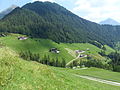
The most important settlements in the valley are Weitental in the narrow entrance area and the higher-lying Pfunders , where the landscape widens to a valley basin. Administratively, the Pfunderer valley belongs entirely to the municipality of Vintl .
Dun in the rear Fundre Valley

Weitenbergtal below the Untere Engbergalm

Weitenbergalm with Grabspitze and Felbesspitze

Engbergtal

Edelrauthütte


literature
- Walter Klier : Zillertal Alps . Alpine Club Guide series . 12th edition. Bergverlag Rother , Munich 2013, ISBN 978-3-7633-1269-6 , pp. 49-50 .
Web links
Coordinates: 46 ° 54 ' N , 11 ° 42' E