Montan
| Montan | |
|---|---|
| (Italian: Montagna ) | |
| coat of arms | map |
| State : | Italy |
| Region : | Trentino-South Tyrol |
| Province : | Bolzano - South Tyrol |
| District community : | Überetsch-Unterland |
|
Inhabitants : (VZ 2011 / 31.12.2019) |
1,627 / 1,714 |
|
Language groups : (according to 2011 census ) |
92.54% German 6.94% Italian 0.52% Ladin |
| Coordinates | 46 ° 20 ' N , 11 ° 18' E |
| Altitude : | 212– 1856 m slm (center: 497 m slm ) |
| Surface: | 18.91 km² |
| Permanent settlement area: | 4.0 km² |
| Parliamentary groups : | Glen, Gschnon, Kaltenbrunn, Pinzon, Kalditsch |
| Neighboring municipalities: | Aldein , Auer , Capriana , Neumarkt , Salurn , Tramin , Truden |
| Postal code : | 39040 |
| Area code : | 0471 |
| ISTAT number: | 021053 |
| Tax number: | 00127760213 |
| Mayor (2015): | Monika Delvai ( SVP ) |
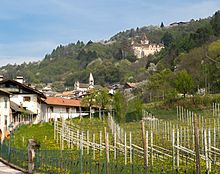
Montan ([ mɔnˈtaˑn ]; Italian Montagna ) is a municipality with 1714 inhabitants (as of December 31, 2019) in the South Tyrolean lowlands in Italy , about 15 kilometers south of Bolzano . The name Montan comes from the Latin mons (mountain). The scenic steep slopes and surroundings - view over the lowlands, on the Lake Caldaro and the opposite Mendelkamm - took the place of some old town houses has even tourism .
geography
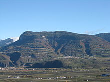
The municipality of Montan, a total of 18.91 km², extends on the orographically left , eastern flank of the Adige Valley , which is called the Unterland between Bozen and the Salurner Klause . Accordingly Montan is due to its elevated position patrimonial sometimes the area under Land Mountain attributed and is Bezirksgemeinschaft überetsch-unterland allocated. The main settlement areas of the municipality are located on a hillside terrace in the middle of the mountains , which offers space for the main town of Montan (390– 530 m slm ) and a little south of it for the two fractions of Pinzon (390– 430 m ) and Glen (520– 580 m ). To the west of the main town, the hill of Castelfeder ( 405 m ) protrudes between Neumarkt and Auer into the Adige Valley. The municipality of Montan also covers a small area of the valley floor below the hill as far as the Adige .
To the east of the main town, the terrain rises to the Cislon ( 1563 m ), a ridge of the wooded mountain range that is part of the Fleimstal Alps and that separates the lowlands from the Fiemme Valley . This is largely under protection in the Trudner Horn Nature Park and bears the municipal boundary to Truden . In the north, the valley of the Schwarzenbach forms the municipal boundary with Aldein ; Here, a narrow strip of territory achieved even a part of the location Kaltbrunn (970- 1000 m ). To the south, another area strip crosses the valley of Trudner Bach and busy - to Truden, Neumarkt, Salurn and Capriana in the Trentino bordering - the north-western slopes of Trudner Horns ( 1781 m ), where the small town is Gschnon (930- 960 m located) .
history
Finds from pre-Christian times show that people already lived in the Montan area at that time. Research results in linguistics in relation to field names and place names support this assumption. Local names of pre-Roman (Gomaroa, Tschalfai) and Romanesque origins (Kalditsch, Montan, Glen, Pinzon) indicate a lively settlement activity in the centuries before and after the birth of Christ.
Colonization by Bavarian settlers began in 955 at the earliest, and reached its peak in the 12th century and ended in the middle of the 13th century. In 1133 the Weyarn Monastery was owned by the Enn Court, and in 1181 the Sonnenburg Monastery in Kalditsch. The Lords of Enn have met in Montan since the middle of the 12th century.
In 1435, pastor Hans Hach von Montan ( "her Hans Hach pharrer zu Montæny" ) was a member of the South Tyrolean priesthood, which committed to holding the Austrian anniversary at the Marian parish church in Bolzano .
Until the end of the First World War, Montan belonged to the County of Tyrol and thus to Austria-Hungary . Within Tyrol, Montan was assigned to the Neumarkt judicial district , which in turn was part of the Bozen district . With the Treaty of Saint-Germain in 1920, Montan came to Italy together with most of Tyrol south of the main Alpine ridge . When the two provinces of Bolzano and Trento emerged in these formerly Austrian areas in 1927, Montan, like some other surrounding communities, was added to the predominantly Italian-speaking province of Trento. It was not until 1948 that Montan was incorporated into the province of Bozen or South Tyrol.

politics
Community leader:
- Michael Rizzolli: 1855, 1857
- Franz Weissensteiner: 1866
- Josef Wegscheider: 1886–1888
- Emil Leys-Paschbach : 1888–1918
- Franz March: 1918–1922
- Jakob Pichler: 1922–1924
Acting Mayor:
- Alois Pernter: 1943-1945
- Jakob Pichler: 1945–1952
Mayor since 1952:
- Alfred March: 1952–1964
- Josef Wegscheider: 1964–1980
- Otto Nussbaumer: 1980–1990
- Alois Amort: 1990-2010
- Monika Delvai: since 2010
education
In Montan there is a German-speaking primary school that is part of the school district of the neighboring municipality of Auer.
Attractions
- Castelfeder is a prehistoric and Roman settlement on a strategically important porphyry hill near Montan ( South Tyrol ) above Auer and represents a multiply structured, spacious hilltop. The "Oberburg" rises around 190 m above the valley floor and is 405 meters above sea level.
- Enn Castle
- Hans-Klocker-Altar, winged altar by the master Hans Klocker from Brixen in the church of St. Stefan von Pinzon
- The grave of the Italian nationalist Ettore Tolomei (1865–1952), known in South Tyrol as the “gravedigger of South Tyrol”, is located in the cemetery . Tolomei acquired the Thalerhof in Glen (district of Montan) in 1905 and moved into it in 1906. With the beginning of the First World War in 1914 Tolomei left Montan and settled in Rome in order to advertise and plan for the annexation of Welschtirol and South Tyrol up to the Brenner border with Italy. Time and again, wreath-laying ceremonies and rallies by Italian neo-fascist politicians and organizations cause a sensation at Tolomei's tomb. Today the tomb is regularly protected by the Carabinieri after it was repeatedly damaged by South Tyrol activists. In the early 1960s there was also a bomb attack on the Thalerhof.
- The former route of the Fiemme Valley Railway is a popular destination in Montan. This railway line was built during the First World War. The route begins in Auer and originally led to Predazzo . On the very well-preserved section of the Auer - San Lugano section there is a much-used cycling and hiking trail. Especially in the Montan - Glen section, it offers a good view of the South Tyrolean lowlands.
Personalities
- Emil Leys-Paschbach (born April 12, 1853 in Vienna; † February 21, 1927 in Montan), politician and economist
Twin cities
See also
Web links
- Website of the municipality of Montan
- Landscape plan of the municipality of Montan . Office for Landscape Ecology, Autonomous Province of Bolzano - South Tyrol (PDF file)
- Information sheet from the municipality of Montan
- Private homepage for Montan
- Entry in the Tirol Atlas of the Institute for Geography at the University of Innsbruck
Individual evidence
- ^ Christoph Haidacher: Montan . Ed .: Schützenkompanie Montan. S. 114 .
- ^ Hannes Obermair : Bozen Süd - Bolzano Nord. Written form and documentary tradition of the city of Bozen up to 1500 . tape 2 . City of Bozen, Bozen 2008, ISBN 978-88-901870-1-8 , p. 78, no.992 .
- ↑ Tiroler Volksbote . November 22, 1922, p. 7 .
- ↑ Meraner Zeitung . January 31, 1918, p. 5 .
- ↑ Tiroler Volksblatt . January 9, 1886, p. 3 .
- ↑ Bolzano newspaper . January 10, 1855, p. 3 .
- ^ The messenger for Tyrol . December 6, 1866, p. 2 .
- ^ Josef Fontana : Montan . Ed .: Schützenkompanie Montan. tape 2 , p. 330 .
- ^ Josef Fontana: Montan . Ed .: Schützenkompanie Montan. tape 2 , p. 368 .
- ↑ The mayors of the South Tyrolean municipalities since 1952. (PDF; 15 MB) In: Festschrift 50 Years of the South Tyrolean Association of Municipalities 1954–2004. Association of South Tyrolean municipalities, pp. 139–159 , accessed on November 16, 2015 .
- ↑ School district Auer. South Tyrolean Citizens' Network , accessed on October 26, 2014 .
- ^ Nuremberg International - Information on the foreign relations of the city of Nuremberg


