Trudner Horn Nature Park
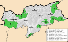
The Trudner Horn Nature Park ( Parco Naturale Monte Corno in Italian ) is a regional park in the South Tyrolean part of the Fiemme Valley Alps ( Italy ). It was founded in 1980 and covers an area of 6,851 hectares, divided into the communities of Altrei , Montan , Neumarkt , Salurn and Truden .
Expansion and habitats
The park is located in the extreme south of South Tyrol along the border with Trentino , about 15 km south of Bolzano . It stretches over the wooded ridges of the Fleimstal Alps, which accompany the Adige Valley on the east side. The most important elevations that rise here between the Unterland , the Fleimstal and the Cembra Valley are the eponymous Trudner Horn ( 1781 m ), the Königswiese ( 1622 m ), the Cislon ( 1563 m ), the Madruttberg ( 1507 m ) and the die Vultures forming the southern border at the Salurner Klause ( 1084 m ). In the north the park ends in the area of the San Lugano saddle .
The Trudner Horn Nature Park stands out among the South Tyrolean nature parks, as it is the only one that is completely below the 2000 m mark and is home to the most diverse flora and fauna. In the different locations one encounters subalpine spruce forests , sub-Mediterranean downy oaks - hop beech - manna ash - bush forests, dry grasslands , mixed forests , wet meadows and moors .
History and facilities
The nature park was founded in 1980 and expanded significantly in 2000. The "Naturparkhaus Trudner Horn", in which the nature of the park is presented, is located in the center of Truden (location: ⊙ ).
Web links
- The Trudner Horn Nature Park in the portal of the South Tyrolean regional administration
Coordinates: 46 ° 17 ' N , 11 ° 19' E


