Durreck
| Durreck | ||
|---|---|---|
|
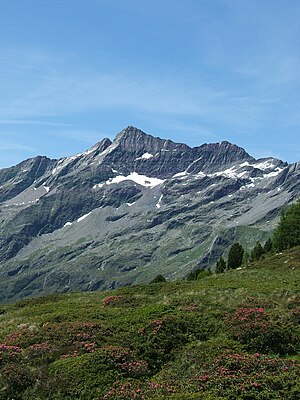
Durreck from the east, from the Kofler Lakes |
||
| height | 3135 m slm | |
| location | South Tyrol , Italy | |
| Mountains | Durreck Group | |
| Notch height | 618 m ↓ white wall | |
| Coordinates | 46 ° 57 '40 " N , 12 ° 1' 45" E | |
|
|
||
| First ascent | July 1877 by C. Arnold (Munich) and Josef Ausserhofer (Rein) | |
| Normal way | From Rein over the southeast ridge ( II ) | |
The Durreck ( 3135 m , also Durreckspitze , Italian Cima Dura ) is the highest mountain in the Durreck Group , a South Tyrolean mountain range that separates the Ahrntal in the north from the Reintal in the south.
Location and surroundings
The Durreck is located in the north-east to south-west running main ridge of the group; The ridge forks at the secondary summit, the Zwieselnöckl (3088 m), which is only about 100 meters to the south-west , into a branch further south to the Großer Moosstock (3059 m) and a further north branch that runs over Klausnock (2819 m), Rauchkofel (2653 m) m), Pojenspitze (2453 m) runs out at Obersteiner Holm (2395 m) above Luttach . In the northeast of the Durreck rises at a distance of half a kilometer, a quite distinctive, yet nameless additional summit (3056 m). In the further north-western course of the main ridge, the Gamskarschneide follow with several elevations just below the 3000 meter mark and then the Hirbernock (3010 m). Northwest of the Durreck is the last remaining glacier remnant of the Durreck group, the Klausenkees , which in 1910 still reached down to 2,300 meters. The entire area is part of the Rieserferner-Ahrn Nature Park .
Alpinism
The first ascent of Durreck was achieved in July 1877 by C. Arnold from Munich with Josef Ausserhofer from Rein . The two started from the Moosmaier-Alm in the south and reached the summit via the southeast ridge. The Durreck was crossed for the first time in the summer of 1883. This was achieved by VH Schnorr from Zwickau with the guide Johann Niederwieser , known as Stabeler, from Taufers. They had started from the north of the Ahrntal and were the first to reach the summit via the northwest ridge. The descent took place over the southeast ridge into the Reintal. On August 20, 1909, another route was first climbed to the Durreck, O. Primus and F. Schaufler from Innsbruck and H. Schwarweber from Pforzheim reached the summit via the northern boundary ridge of the Klausenkee.
Like the first climber, the ascent that is mostly done today leads over the southeast ridge. You usually start in Rein and walk on alpine paths to the Unterrieseralm, where you leave the alpine path and climb far into the wild cirque between Durreck and Moosstock in a pathless direction north-west. Over a short, smooth rock step and a channel you finally climb to the right to the southeast ridge. The summit is reached via the south-east ridge, which has recently become steeper. The ascent requires some climbing in brittle rock ( II ).
Literature and map
- Hermann Schwarzweber: The Durreck Group. A contribution to their development. In: Journal of the German and Austrian Alpine Club. 41: pp. 202-240, Munich 1910 (online at ALO ).
- Carl Diener : The Rieserferner Group. In: Eduard Richter (Ed.): The development of the Eastern Alps. III. Band, Berlin 1894 ( online ).
- Topographic hiking map, Ahrntal / Rieserferner Group , sheet 035, 1: 25,000, Casa Editrice Tabacco, ISBN 88-8315-035-X .
Individual evidence
- ↑ Schwarzweber: The Durreck Group. P. 206, see literature.
- ↑ Schwarzweber: The Durreck Group. P. 212f., See literature.
- ↑ Tauferer Bötl. Bulletin of the market town of Sand in Taufers , May 2008, p. 46f. ( online ).
- ^ Carl Diener: The Rieserferner Group. In: Eduard Richter (Ed.): The development of the Eastern Alps. III. Volume, Berlin 1894, pp. 128f. ( online ).
- ↑ Maurizio Marchel: Lonely peaks. South Tyrol - Dolomites. Volume 2. Tappeiner. Lana 2013, ISBN 978-88-7073-714-1 , pp. 68f.
- ^ Richard Goedeke: 3000 m in the northern Alps. Bruckmann, Munich 2004, ISBN 3-7654-3930-4 , pp. 160f.


