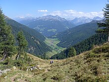
Weißenbachtal (Ahrntal)
The Weißenbachtal ( Italian: Valle di Rio Bianco ), also simply called Weißenbach , is a mountain valley in the South Tyrolean part of the Zillertal Alps in Italy . It is drained from the Weißenbach . It is an orographically right side valley of the Ahrntal , which branches off westwards at Luttach . After the main town of the valley, Weißenbach , it branches into a southwest and a northwest branch. The former is known as the Wurmtal , the latter as the Trattenbachtal .
The Weißenbachtal is bordered on the north by the Zillertal main ridge (max. 3509 m ), which on this section with the Hornspitzen is 3253 m and Turnerkamp 3418 m and bears the Italian-Austrian border .
At Turnerkamp, the Mühlwalder Kamm branches off to the south, which later turns east to end at the western foot of the Speikboden massif before Sand in Taufers . This mountain range, on which the Chemnitzer Hütte ( 2419 m ) is a base for mountaineers, separates the Weißenbachtal from the Mühlwalder valley on the west and south sides .
Administratively, the entire valley belongs to the municipality of Ahrntal .
literature
- Walter Klier : Zillertal Alps . Alpine Club Guide series . 12th edition. Bergverlag Rother , Munich 2013, ISBN 978-3-7633-1269-6 , pp. 61-62 .
Individual evidence
- ^ Egon Kühebacher : The place names of South Tyrol and their history. The historically evolved names of the valleys, rivers, streams and lakes. Athesia, Bozen 1995, ISBN 88-7014-827-0 , p. 368.
Coordinates: 46 ° 57 ' N , 11 ° 52' E
