
Bergstrasse district
| coat of arms | Germany map |
|---|---|

|

Coordinates: 49 ° 38 ' N , 8 ° 39' E |
| Basic data | |
| State : | Hesse |
| Administrative region : | Darmstadt |
| Administrative headquarters : | Heppenheim (Bergstrasse) |
| Area : | 719.52 km 2 |
| Residents: | 270,340 (Dec. 31, 2019) |
| Population density : | 376 inhabitants per km 2 |
| License plate : | HP |
| Circle key : | 06 4 31 |
| NUTS : | DE715 |
| Circle structure: | 22 municipalities |
| Address of the district administration: |
Gräffstrasse 5 64646 Heppenheim (Bergstrasse) |
| Website : | |
| District Administrator : | Christian Engelhardt ( CDU ) |
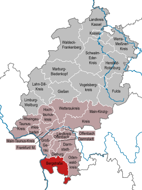
| Location of the Bergstrasse district in Hesse | |
  |
|
The Bergstrasse district is a district in the Darmstadt administrative district in Hesse . It is part of the metropolitan regions Rhine-Main and Rhine-Neckar and consists of ten cities, twelve other municipalities and the municipality-free area Michelbuch .
geography
location
Part of the district is in the Odenwald , the other is in the Upper Rhine Plain and is partly part of the Hessian Ried . The two cities of Hirschhorn and Neckarsteinach in the Neckar Valley and the Michelbuch district have no direct connection to the rest of the district and form an exclave .
It is named after the Bergstrasse , a tourist route that leads south from Darmstadt to Wiesloch in Baden-Württemberg. The northern part of this route runs through the Bergstrasse district.
Neighboring areas
The district borders clockwise in the northwest, starting with the districts of Groß-Gerau , Darmstadt-Dieburg and Odenwaldkreis (all in Hesse), the Rhein-Neckar district and the urban district of Mannheim (both in Baden-Württemberg ). In the west, the Rhine forms the natural border with Rhineland-Palatinate . Here the district borders briefly on the Rhine-Palatinate district , the independent city of Worms and the district of Alzey-Worms .
history
Before 1800, the area of the Bergstrasse district belonged largely to Kurmainz , partly to the Electoral Palatinate , the Landgraviate of Hessen-Darmstadt and the County of Erbach-Schönberg . After the Reichsdeputationshauptschluss 1803 it came to Hessen-Darmstadt, the later Grand Duchy of Hessen in the province of Starkenburg . The administrative units were initially the offices of Bensheim , Fürth , Gernsheim , Heppenheim , Hirschhorn , Kürnbach , Lampertheim , Lindenfels , Lorsch , Pfungstadt , Schönberg , Seeheim , Wald-Michelbach , Wimpfen and Zwingenberg. In 1821 administrative districts were established instead of the offices. These were the forerunners of the circles. In the area of today's Bergstrasse district, the districts of Bensheim , Heppenheim , Hirschhorn and Lindenfels as well as Wimpfen with the Kürnbach office were formed as an exclave in Baden. Some places were given to neighboring districts.
After the reorganization announced on August 20, 1832, there should only be districts in Süd-Starkenburg in future, not district districts, namely the district of Bensheim and the district of Lindenfels . Heppenheim was intended to be incorporated into the Bensheim district; its district council should fall to the district of Bensheim. Even before the ordinance came into force on October 15, 1832, it was revised to the effect that instead of the Lindenfels district, the Heppenheim district was formed as a second district alongside the Bensheim district, and the city of Heppenheim was therefore not incorporated into the Bensheim district. The Wimpfen district remained an independent administrative district.
On July 31, 1848, the two districts of Bensheim and Heppenheim were then merged to form the administrative district of Heppenheim . The district of Wimpfen came to the administrative district of Erbach . However, this administrative reform only lasted four years, because on May 12, 1852 the merger was lifted again. The Lindenfels district and the new Wimpfen district were created again , but they were finally dissolved in 1874 and added to the Bensheim and Heppenheim districts. After the dissolution of the provincial and district assemblies in what is now the People's State of Hesse (from 1918) and the dissolution of the three provinces of Starkenburg, Upper Hesse and Rheinhessen in 1937 , the year 1938 brought a review of the district boundaries. On November 1, 1938, a decisive regional reform was carried out in Hesse. In each of the three former Hessian provinces of Starkenburg, Rheinhessen and Upper Hesse, one district was dissolved. In Starkenburg, this affected the Bensheim district, whose area was divided into three neighboring districts. The largest part was added to the district of Heppenheim, which also took over the legal successor to the district of Bensheim and was renamed the Bergstrasse district at the same time. The area of today's communities Alsbach-Hähnlein , Bickenbach and Seeheim-Jugenheim (without Malchen ) came to the district of Darmstadt , while the area of today's communities Biblis , Bürstadt , Groß-Rohrheim and Lampertheim was given to the district of Worms .
The demarcation of the occupation zones along the Rhine after 1945 ensured that the areas on the right bank of the Rhine in the district of Worms and the independent city of Worms were incorporated into the Bergstrasse district. In return, Bad Wimpfen, which had previously belonged to the Bergstrasse district as an exclave, was surrendered to the Baden district of Sinsheim by an Allied decree .
During the regional reform in Hesse , the Bergstrasse district was hardly changed in its external borders. Only the municipality of Laudenau went to the district of Erbach on July 1, 1971 after a public survey and became a district of the municipality of Reichelsheim in the Odenwald .
Population statistics
The development of the population in the Bensheim, Heppenheim and Bergstrasse districts.
- Bensheim and Heppenheim districts
| year | Bensheim district | Heppenheim district |
|---|---|---|
| 1900 | 55,916 | 47,083 |
| 1910 | 65,760 | 51.909 |
| 1925 | 72,863 | 55,087 |
| 1933 | 78.917 | 59,000 |
Bergstrasse district
| year | Bergstrasse district |
|---|---|
| 1939 | 97.105 |
| 1950 | 170.373 |
| 1961 | 186,562 |
| 1969 | 226.100 |
| 1970 | 223.991 |
| 1987 | 240.111 |
| 1990 | 248,500 |
| 2001 | 264,695 |
| 2007 | 264,380 |
| 2011 | 260.741 |
| 2015 | 264,893 |
| 2020 | 270.366 |
Denomination statistics
According to the 2011 census , 31.8% of the population were Protestant , 37.8% Roman Catholic and 30.4% were non-denominational , belonged to another religious community or did not provide any information. The number of Catholics and Protestants has fallen since then. At the end of 2019, the district had 28.4% (76,704) Protestant church members out of a total of 270,340 inhabitants.
politics
District council
The local elections on March 6, 2016 produced the following results, compared to previous local elections:
| Diagram showing the election results and the distribution of seats | |
|---|---|
| Nominations | % 2016 |
Seats 2016 |
% 2011 |
Seats 2011 |
% 2006 |
Seats 2006 |
% 2001 |
Seats 2001 |
|
|---|---|---|---|---|---|---|---|---|---|
| CDU | Christian Democratic Union of Germany | 33.1 | 24 | 36.8 | 30th | 42.3 | 34 | 43.2 | 35 |
| SPD | Social Democratic Party of Germany | 23.9 | 17th | 29.2 | 23 | 34.0 | 28 | 38.8 | 31 |
| AfD | Alternative for Germany | 15.9 | 11 | - | - | - | - | - | - |
| GREEN | Alliance 90 / The Greens | 11.1 | 8th | 19.4 | 16 | 8.0 | 6th | 7.3 | 6th |
| FDP | Free Democratic Party | 6.9 | 5 | 3.8 | 3 | 5.6 | 4th | 4.5 | 4th |
| FREE VOTERS | Free voters in the Bergstrasse district | 4.7 | 3 | 5.1 | 4th | 4.6 | 4th | 5.7 | 5 |
| THE LEFT. | THE LEFT. | 3.1 | 2 | 2.2 | 2 | 2.3 | 2 | - | - |
| PIRATES | Pirate Party Germany | 1.0 | 1 | 1.3 | 1 | - | - | - | - |
| FLB | Free list mountain road | 0.3 | 0 | - | - | - | - | - | - |
| REP | The Republicans | - | - | 2.3 | 2 | 3.2 | 3 | - | - |
| total | 100.0 | 71 | 100.0 | 81 | 100.0 | 81 | 100.0 | 81 | |
| Voter turnout in% | 47.6 | 49.3 | 46.0 | 52.0 | |||||
Note: As of October 4, 2017, the strengths of the factions in the FDP and AfD have shifted: the AfD faction now only has nine members, the FDP faction now has seven members.
A majority coalition consisting of the CDU, FDP and FWG has ruled since the district elections in 2001, replacing the previous ruling grand coalition. In 2011 this coalition lost its majority and was replaced by an alliance between the CDU and the Greens, which in turn lost its majority in 2016.
District administrators

| Surname | Political party | Term of office |
|---|---|---|
| Walther Nanz | NSDAP | 1939 to 1945 (appointed) |
| Gustav King | independent | 1945 (appointed) |
| Wilhelm Dengler | SPD | 1945 to 1946 |
| Hans Steinmetz | CDU | 1946 to 1948 |
| Wilhelm Dengler | SPD | 1948 to 1951 |
| Ekkehard Lommel | SPD | 1951 to 1976 |
| Lothar Bergmann | SPD | 1976 to 1982 |
| Franz Hartnagel | CDU | 1982 to 1985 |
| Dietrich Kassmann | SPD | 1985 to 1997 |
| Norbert Hofmann | SPD | 1997 to 2003 (direct election) |
| Matthias Wilkes | CDU | 2003 to September 15, 2015 (direct election) |
| Christian Engelhardt | CDU | from September 16, 2015 (direct election) |
The electoral period for district administrators is regulated in the Hessian municipal electoral law and is six years. The next district election will take place in 2021.
Coat of arms, flag and banner

Hoist flag

banner

The Bergstrasse district has a coat of arms, a hoisted flag and a banner . The coat of arms was approved by the Hessian Ministry of the Interior on October 27, 1954 , the flag on June 5, 1955.
|
|
Blazon : “The fourth shield shows in the 1st blue field a silver pinnacle tower on a silver mountain; in the second silver field a red five-petalled flower with golden clusters; in the 3rd silver field the red Lorsch Nagelspitz cross and in the 4th blue field the Hessian lion. " |
| Justification of the coat of arms: The silver tin tower represents the Starkenburg , one of the most important fortifications in the region (today a ruin). The red five-petalled flower stands for the variety of flowers in spring. The Nagelspitzkreuz is the coat of arms of the Lorsch Monastery . |
Flag description: "The coat of arms of the Bergstrasse district on the white central panel of the red-white-red flag cloth."
Economy and Infrastructure
economy

In the Future Atlas 2016 , the Bergstrasse district was ranked 101st out of 402 districts, municipal associations and urban districts in Germany, making it one of the regions with “future opportunities”. In the 2019 edition, it was ranked 130th out of 401.
The Bergstrasse is a tourist region. In the very mild climate, tobacco , asparagus and wine are also grown. Significant sights are the Felsenmeer in Lautertal , the Carolingian King's Hall of the former Lorsch Monastery (UNESCO World Heritage Site since 1991), the Starkenburg near Heppenheim, the Auerbach Castle and the Fürstenlager State Park near Bensheim-Auerbach.
Internationally operating companies such as BASF (formerly Ciba , Lampertheim), IXYS Semiconductor (Lampertheim), Langnese-Iglo (Heppenheim), SAP SI (Bensheim), Sirona (Bensheim), Suzuki (Bensheim) and Tyco Electronics (Bensheim) are located on Bergstrasse. settled.
traffic
The federal highways 5 (Heidelberg – Darmstadt), 6 (Kaiserslautern – Heilbronn), 67 (Mannheim – Darmstadt) and 659 run through the district . In addition, the district area is accessed by several federal and district roads, including the B 3 (Heidelberg – Darmstadt), the B 37 , B 38 ( Saukopftunnel ), B 44 , B 47 and B 460 .

In terms of rail traffic, the Bergstrasse district is connected by the electrified main lines Main-Neckar-Bahn (Frankfurt - Darmstadt - Mannheim / Heidelberg) and Riedbahn (Frankfurt - Biblis - Mannheim). In long-distance traffic, Heppenheim station is served by individual Intercity trains and in Bensheim with ICE trains every two hours. Furthermore with existing Nibelungen Railway and Weschnitz Valley Railway two diesel-powered branch lines and over forest railway , which currently only in leisure traffic with solar Handcars between Mörlenbach and Wald-Michelbach is traveled . The Wald-Michelbach - Wahlen section has been dismantled and is used as a footpath and cycle path .
The local public transport in the district is organized together with the other districts of the Rhine-Neckar triangle in the Verkehrsverbund Rhein-Neckar (VRN). A transitional tariff between VRN and Rhein-Main-Verkehrsverbund (RMV) applies to journeys from / to the neighboring districts in Hesse , in which some RMV tickets are recognized (journeys in the district) or these can be purchased for journeys to the RMV area can (trips out of the circle).
According to the network hierarchy in the local transport plan 2014-2018, the bus route network consists of first-order lines (“competition with individual motorized transport”), second-order lines (“alternative to individual motorized transport”) and a supplementary network (“training transport and basic services”). An overview of the route network, broken down by means of transport (bus / train) and days of traffic, is provided in the adjacent route network map. There are also city bus routes in Bensheim, Bürstadt, Lampertheim and Viernheim .
With the “Bensheim, Autohof” stop, the Bergstrasse district could also be reached by long-distance buses at times .
Communities


(Residents on December 31, 2019)
|
|
Former parishes
The following table contains all the former municipalities of the Bergstraße district as well as the data of all incorporations:
License Plate
On July 1, 1956, the district was assigned the distinctive sign HP when the license plates that are still valid today were introduced . It stands for the district town of Heppenheim (Bergstrasse) and is still issued today.
literature
- Wolfgang Einsingbach: The art monuments of the state of Hesse: Bergstrasse district . Published by the State Curator of Hesse on behalf of the Hessian Minister of Culture. Deutscher Kunstverlag, Munich / Berlin 1969, DNB 457322012 .
- Ulla Hess: flowers, vines, dragon's blood. The Bergstrasse district . Diesbach Medien, Weinheim 2008, ISBN 978-3-936468-41-0 .
- Friedrich Kopetzky, Hans Todt: Bergstrasse district - land on the Rhine and Neckar . District committee of the Bergstrasse district in Heppenheim, 1986, DNB 871499223 .
- District administration of the Bergstrasse district (ed.): Bergstrasse district - landscape and nature, leisure and culture, economy and social affairs. Portrait of German districts . Oldenburg Communication & Economy, 2004, ISBN 3-88363-231-7 .
Web links
- Website of the Bergstrasse district
- Link catalog on the subject of the Bergstrasse district at curlie.org (formerly DMOZ )
- Literature from and about Bergstrasse district in the catalog of the German National Library
- Bergstrasse district. Historical local dictionary. In: Landesgeschichtliches Informationssystem Hessen (LAGIS).
Individual evidence
- ↑ Hessian State Statistical Office: Population status on December 31, 2019 (districts and urban districts as well as municipalities, population figures based on the 2011 census) ( help ).
- ↑ 175 years of BA - 175 headlines. (PDF; 9.0 MB) The creation of the Bergstrasse district. In: Morgenweb. Bergsträßer Anzeiger, January 1, 2007, p. 109 , archived from the original on December 20, 2014 ; Retrieved February 9, 2015 .
- ^ State of Hesse 1939 administrative structure , as of May 10, 2008
- ↑ Administrative division 1939 and 1955. Historical Atlas of Hesse. In: Landesgeschichtliches Informationssystem Hessen (LAGIS).
- ↑ Law on the reorganization of the Bergstrasse district (GVBl. II 330–15) of July 11, 1972 . In: The Hessian Minister of the Interior (ed.): Law and Ordinance Gazette for the State of Hesse . 1972 No. 17 , p. 222 ff . ( Online at the information system of the Hessian State Parliament [PDF; 1,2 MB ]).
- ^ Federal Statistical Office (ed.): Historical municipality directory for the Federal Republic of Germany. Name, border and key number changes in municipalities, counties and administrative districts from May 27, 1970 to December 31, 1982 . W. Kohlhammer, Stuttgart / Mainz 1983, ISBN 3-17-003263-1 , p. 358 .
- ^ Michael Rademacher: German administrative history from the unification of the empire in 1871 to the reunification in 1990. Bergstrasse district. (Online material for the dissertation, Osnabrück 2006).
- ↑ Population figures in regional comparison. In: 2011 census . Hessian State Statistical Office , accessed in April 2019 .
- ↑ Population in the administrative districts on June 30, 2015 and change in population in the 2nd quarter of 2015. Hessian State Statistical Office, archived from the original on March 24, 2016 ; accessed on May 31, 2019 .
- ↑ Population of the districts on March 31, 2020 In: Website of the Hessian State Statistical Office . Format: XLSX.
- ↑ District Bergstrasse Religion , 2011 census
- ↑ Statistics 2019 , accessed on August 21, 2020
- ^ Hessian State Statistical Office: Results of the district elections of 2016 and 2011
- ^ Hessian State Statistical Office: Results of the district elections of 2011 and 2006
- ^ Hessian State Statistical Office: Results of the district elections of 2006 and 2001
- ^ Hessian State Statistical Office: Results of the district elections of 2001 and 1997
- ↑ 2006 election: WASG
- ↑ The Animal Welfare Party won no seat in 2001, but 0.5% of the vote.
- ^ The district council of the Bergstrasse district (overview of the Bergstrasse district website with parliamentary groups, as of October 4, 2017); accessed on November 8, 2017
- ^ Approval of a coat of arms of the Bergstrasse district in the Darmstadt administrative district of October 27, 1954 . In: The Hessian Minister of the Interior (ed.): State Gazette for the State of Hesse. 1954 No. 46 , p. 1089 , item 1125 ( online at the information system of the Hessian state parliament [PDF; 3.1 MB ]).
- ^ Approval of a flag for the Bergstrasse district in the Darmstadt administrative district on June 5, 1955 . In: The Hessian Minister of the Interior (ed.): State Gazette for the State of Hesse. 1955 no. 25 , p. 616 , point 667 ( online at the information system of the Hessian state parliament [PDF; 2.8 MB ]).
- ↑ Zukunftsatlas 2016. Archived from the original ; accessed on March 23, 2018 . }
- ↑ PROGNOS future atlas. Handelsblatt, accessed on December 10, 2019 .
- ^ ICE train stations in Bensheim and Heppenheim. .
- ↑ Draisine Überwaldbahn.
- ↑ Local transport plan for the Bergstrasse district 2014-2018. VRN
- ↑ Bus from Bensheim. Flixbus , archived from the original on April 12, 2016 .
- ↑ Hessian State Statistical Office: Population status on December 31, 2019 (districts and urban districts as well as municipalities, population figures based on the 2011 census) ( help ).
- ↑ All former municipalities in the district . Historical local dictionary for Hessen. In: Landesgeschichtliches Informationssystem Hessen (LAGIS).

Province of Upper Hesse : Alsfeld | Büdingen | Friedberg | Casting | Lauterbach |
Newly founded in 1938: Stadtkreis Gießen
Disbanded in 1938: Schotten
Province of Rheinhessen : Alzey | Bingen | Mainz | Worms
Newly founded in 1938: Stadtkreis Mainz | Worms district
Disbanded in 1938: Oppenheim
Starkenburg Province : Darmstadt | Dieburg | Erbach | Groß – Gerau | Offenbach |
Newly founded in 1938: Darmstadt district | Offenbach am Main district | Bergstrasse district
Disbanded in 1938: Bensheim | Heppenheim
Counties: Bergstrasse | Darmstadt-Dieburg | Fulda | Casting | Gross-Gerau | Hersfeld-Rotenburg | Hochtaunuskreis | Kassel (Country) | Lahn-Dill-Kreis | Limburg-Weilburg | Main-Kinzig-Kreis | Main-Taunus-Kreis | Marburg-Biedenkopf | Odenwaldkreis | Offenbach (State) | Rheingau-Taunus-Kreis | Schwalm-Eder district | Vogelsbergkreis | Waldeck-Frankenberg | Werra-Meißner district | Wetteraukreis
Independent cities: Darmstadt | Frankfurt am Main | Kassel | Offenbach am Main | Wiesbaden
Independent cities: Frankenthal (Pfalz) | Heidelberg | Landau in the Palatinate | Ludwigshafen am Rhein | Mannheim | Neustadt an der Weinstrasse | Speyer | Worms
Districts: Bad Dürkheim | Mountain road | Germersheim | Neckar-Odenwald | Rhine-Neckar | Rhine-Palatinate | Southern Wine Route