
Hochstädten (Bensheim)
|
High cities
City of Bensheim
|
|
|---|---|
.png) |
|
| Height : | 196 m above sea level NHN |
| Residents : | 712 (Jun. 30, 2019) |
| Incorporation : | December 31, 1971 |
| Postal code : | 64625 |
| Area code : | 06251 |
 Map of Bensheim with the district Hochstädten
|
|


Hochstädten is a district of Bensheim an der Bergstrasse with around 750 inhabitants . It is located northeast of Bensheim in the Mühltal, a valley in the Vorderen Odenwald . The only connecting road is the L 3103 through Hochstädten and leads in a north-easterly direction to Balkhausen , a district of Seeheim-Jugenheim and in a south-westerly direction to Auerbach , a district of Bensheim.
Geographical location
Hochstädten is located in the Bergstrasse district in southern Hesse in a valley in the front Odenwald , which leads to the Upper Rhine Plain . Coming from the B3 in Auerbach, the Mühltal leads the L 3103, along the Auer , also called Mühlbach, via Hochstädten and Balkhausen on to the Kuralpe with the nearby Felsenmeer and deeper into the Odenwald. The closest localities are Elmshausen in the southeast, Reichenbach in the east, Balkhausen in the north, Auerbach in the west, Bensheim in the southwest and Schönberg in the south.
Hochstädten is at the southeastern foot of the Melibokus . The Auerbach Castle and the Prince's Camp are within easy walking distance.
history
The village, first mentioned in a Katzenelnbogen document in 1312 , probably originated from a farm belonging to the "Adelhelm von Hovesteten", which is mentioned in an undated document from the Lorsch Codex. In the historical documents, Hochstädten is mentioned in the following centuries with the following place names, among others : Houesteten (around 1200), Hobesteden (1318), Hoffsteten (1398–1400), Hofstaden (1431), Hofstetten (1435), Hochstätten (1745) and Hochstetten (1771).
The Katzenelnbogen inheritance fell with Hochstädten in 1479 to the Landgraviate of Hesse . In 1567, the Landgraviate of Hessen-Darmstadt emerged from the Landgraviate of Hessen as the Principality of the Holy Roman Empire of the German Nation . After the Thirty Years' War the village was almost extinct and was only revived by settlers from German countries, but also from France, Switzerland and Austria. The founding of the first glassworks in the Odenwald on the northern slope of the Felsberg in the Hochstädter district also dates from this time.
Just 50 years after the end of the Thirty Years' War, the region suffered again from the consequences of the war when France tried to move its borders to the east. It was not until the Peace of Rijswijk in 1697 that the French withdrew behind the Rhine. During the Napoleonic Wars , under pressure from Napoleon in 1806, the Grand Duchy of Hesse was created , which incorporated the Landgraviate of Hesse-Darmstadt. The Grand Duchy of Hesse was a member state of the German Confederation from 1815 to 1866 and then a federal state of the German Empire . It existed until 1919, after the First World War, the Grand Duchy for was republican written People's State of Hesse . In 1945 after the end of the Second World War , the area of today's Hesse was in the American zone of occupation and the state of Hesse was created within its current boundaries by order of the military government .
Under Hessian rule, Hochstädten was administratively part of the Hessian office of Zwingenberg until 1820 , which from 1806 belonged to the Starkenburg province of the Grand Duchy of Hesse . In 1821, as part of a comprehensive administrative reform, the district bailiffs in the provinces of Starkenburg and Upper Hesse of the Grand Duchy were dissolved and districts were introduced, with Hochstädten being assigned to the district of Bensheim . As part of this reform, regional courts were also created, which were now independent of the administration. The District Court of Zwingenberg was the court of first instance responsible for the district of Bensheim .
The statistical-topographical-historical description of the Grand Duchy of Hesse reports on Hochstädten in 1829:
»Hochstädten (L. Bez. Bensheim) Lutheran Filialdorf: is 1 St. from Bensheim, and has 27 houses and 201 Lutheran residents. There are 2 oil mills, with which a grinding mill is connected, and the area contains limestone quarries and sources of sour water, which the latter are not used. There is also an abandoned lead mine. "
In 1832 the units were enlarged one more time and circles were created. This brought Hochstädten into the Bensheim district . As a result of the March Revolution of 1848, with the "Law on the Relationships of the Classes and Noble Court Lords" of April 15, 1848, the special rights of the class were finally repealed. In addition, in the provinces, the districts and the district councils of the Grand Duchy were abolished on July 31, 1848 and replaced by "administrative districts", but this was reversed on May 12, 1852. As a result, Hochstädten belonged to the Heppenheim administrative district from 1848 to 1852 , before the Bensheim district was again responsible for the higher-level administration. The Hessian provinces of Starkenburg, Rheinhessen and Upper Hesse were abolished in 1937 after the provincial and district assemblies were dissolved in 1936. On November 1, 1938, a comprehensive regional reform came into force at the district level. In the former province of Starkenburg, the Bensheim district was particularly affected, as it was dissolved and most of it was added to the Heppenheim district. The district of Heppenheim also took over the legal successor to the district of Bensheim and was given the new name Landkreis Bergstrasse .
The Grand Duchy of Hesse was a member state of the German Confederation from 1815 to 1866 and then a federal state of the German Empire . It existed until 1919, after the First World War, the Grand Duchy for was republican written People's State of Hesse . In 1945 after the end of the Second World War , the area of today's Hesse was in the American zone of occupation and by order of the military government, Greater Hesse was created , from which the state of Hesse emerged in its current borders.
The competent jurisdiction was during the affiliation to Hesse, from 1821 to 1879 the regional court Zwingenberg and from 1879 resulting from it local court Zwingenberg . From 1934 the district court area of Zwingenberg was abolished and added to the district court Bensheim , which is responsible to this day.
In 1901 the Hochstädter Sportverein was founded, in 1904 the currently dormant choral society, in 1908 the volunteer fire brigade , in 1960 its minstrel 's march and in 1964 the Kerwe and Heimatverein.
After Hochstädten was an agricultural place for centuries, there is now only one full-time and one part-time business. Closely connected with the village is the history of the mining of Auerbach marble , since 1865 on a larger scale by the Hoffmann company, which mainly burned lime from the stone. In 1905 the company was bought by Ludwig Linck, whose son Karl Linck had developed the legally protected “Marmorit” dry mortar.
Towards the end of the Second World War , around 130 Greek slave laborers were working in the Hochstädter Marmorit plant. According to court records, they worked under "terrible conditions" for the Darmstadt factory owner Hans Heymann. From 1944, he let qualified concentration camp prisoners such as technicians, draftsmen, designers and chemists work for himself. In 1944, among other things, he had an external concentration camp built in order to produce armaments technology essential to the war in an underground tunnel in the Marmorit works - protected from the bombs of the Allies. 13 forced laborers were killed while the factory was being built. Concentration camp prisoners were also used here. On a map in the Buchenwald concentration camp , Bensheim and Heppenheim are listed as subcamps of the Natzweiler-Struthof concentration camp in Alsace . The command of the satellite camp existed from August 1944 to March 1945. The prisoners were housed in wooden barracks on the premises of the Friedrich Sanner company in Bensheim-Auerbach and had to walk for kilometers every day. When the American troops reached the Rhine at the end of March , the camp was evacuated and the inmates had to make the long march under strict guard to Schwäbisch Hall , from where they were transported to the Dachau concentration camp . Several of the prisoners died there before they were freed by the Americans at Tegernsee.
In 1961 the size of the district was given as 388 hectares , 140 hectares of which were forest.
In the spring of 2004, Hochstädten hit the headlines when neo-Nazis tried to rent an unused hall in Hochstädten and clashes ensued.
The Marmorit factory that ultimately belonged to the Knauf Group was closed on March 31, 2008 after 143 years of factory history.
Territorial reform
In the course of the regional reform in Hesse , Hochstädten became a district of Bensheim on December 31, 1971 and today has around 800 inhabitants. For Hochstädten, as for the other parts of the city, a local district with a local advisory board and local councilor was set up in accordance with the Hessian municipal code. In 2007 the new coat of arms of the municipality was created based on a concept by the heraldist Frieder Boss, employee of the Hessian State Archives in Darmstadt.
Territorial history and administration
The following list gives an overview of the territories in which Hochstädten was located or the administrative units to which it was subordinate:
- before 1479: Holy Roman Empire , County Katzenelnbogen , Upper County Katzenelnbogen , Amt Zwingenberg
- from 1479: Holy Roman Empire, Landgraviate of Hesse , Upper County of Katzenelnbogen, Amt Zwingenberg
- from 1567: Holy Roman Empire, Landgraviate of Hessen-Darmstadt , Upper County of Katzenelnbogen (1783: Amt Zwingenberg and Jägersburg )
- from 1803: Holy Roman Empire, Landgraviate Hessen-Darmstadt, Principality of Starkenburg , Amt Zwingenberg and Jägersburg
- from 1806: Confederation of the Rhine , Grand Duchy of Hesse , Principality of Starkenburg, Zwingenberg Office
- from 1815: German Confederation , Grand Duchy of Hesse, Province of Starkenburg , Zwingenberg Office
- from 1821: German Confederation, Grand Duchy of Hesse, Starkenburg Province, Bensheim District District (separation between the judiciary ( Zwingenberg District Court ) and administration)
- from 1832: German Confederation, Grand Duchy of Hesse, Starkenburg Province, Bensheim district
- from 1848: German Confederation, Grand Duchy of Hesse, administrative district of Heppenheim
- from 1852: German Confederation, Grand Duchy of Hesse, Province of Starkenburg, District of Bensheim
- from 1867: Grand Duchy of Hesse, Starkenburg Province, Bensheim district
- from 1871: German Empire , Grand Duchy of Hesse, Province of Starkenburg, Bensheim district
- from 1918: German Empire, People's State of Hesse , Starkenburg Province, Bensheim district
- from 1938: German Empire, People's State of Hesse, Bergstrasse district (In the course of the regional reform in 1938 , the three Hessian provinces of Starkenburg, Rheinhessen and Upper Hesse were dissolved.)
- from 1945: American zone of occupation , Greater Hesse , Darmstadt administrative district, Bergstrasse district
- from 1949: Federal Republic of Germany , State of Hesse , Darmstadt district, Bergstrasse district
- On December 31, 1971, Hochstädten was incorporated into the city of Bensheim as a district.
Population development
| • 1629: | 10 house seats |
| • 1791: | 143 inhabitants |
| • 1800: | 148 inhabitants |
| • 1806: | 172 inhabitants, 24 houses |
| • 1829: | 201 inhabitants, 27 houses |
| • 1867: | 247 inhabitants, 38 houses |
| Hochstädten: Population from 1791 to 2019 | ||||
|---|---|---|---|---|
| year | Residents | |||
| 1791 | 143 | |||
| 1800 | 148 | |||
| 1806 | 172 | |||
| 1829 | 201 | |||
| 1834 | 242 | |||
| 1840 | 267 | |||
| 1846 | 267 | |||
| 1852 | 264 | |||
| 1858 | 238 | |||
| 1864 | 229 | |||
| 1871 | 269 | |||
| 1875 | 256 | |||
| 1885 | 272 | |||
| 1895 | 213 | |||
| 1905 | 242 | |||
| 1910 | 262 | |||
| 1925 | 264 | |||
| 1939 | 281 | |||
| 1946 | 388 | |||
| 1950 | 399 | |||
| 1956 | 359 | |||
| 1961 | 323 | |||
| 1967 | 406 | |||
| 1970 | 406 | |||
| 1980 | ? | |||
| 1990 | ? | |||
| 2000 | ? | |||
| 2007 | 726 | |||
| 2010 | 695 | |||
| 2011 | 669 | |||
| 2015 | 684 | |||
| 2019 | 712 | |||
| Data source: Historical municipality register for Hesse: The population of the municipalities from 1834 to 1967. Wiesbaden: Hessisches Statistisches Landesamt, 1968. Further sources:; City of Bensheim :; 2011 census : | ||||
Religious affiliation
| • 1829: | 201 Lutheran (= 100%) residents |
| • 1961: | 272 Protestant (= 84.21%), 46 Catholic (= 14.24%) residents |
politics
For Gronau, there is a local district (areas of the former municipality of Fehlheim) with a local advisory board and local mayor according to the Hessian municipal code . The local advisory board consists of seven members.
Local advisory board
The local election on March 6, 2016 produced the following results:
| Parties and constituencies |
% 2016 |
Seats 2016 |
% 2011 |
Seats 2011 |
|
| DGH | Hochstädten village community | 100 | 7th | 100 | 7th |
| Voter turnout in% | 45.9 | 55.7 | |||
Mayor
- Mayor : Bernhard Rettig, DGH
- Deputy : Susanne Hummel, DGH
2016 election results:
DGH: 7 seats
| rank | person | be right |
|---|---|---|
| 1 | Rettig, Bernhard | 488 |
| 2 | Hummel, Susanne | 380 |
| 3 | Rettig, Thomas | 208 |
| 4th | Henkes, Michael | 200 |
| 5 | Dr. Reil hero, Anette | 176 |
| 6th | Klemm, Rosemarie | 168 |
| 7th | Daubner, Torsten | 143 |
coat of arms
The seal from 1579 shows a coat of arms with St. Sebastian in a typical pose, tied to a column and pierced by arrows. In 2007 the new coat of arms of the municipality was created based on a concept by the heraldist Frieder Boss (†), employee of the Hessian State Archives in Darmstadt.
Sights and culture


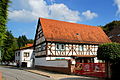
- The gabled half-timbered houses from the 17th century are lined up on both sides along the village street. The half-timbered house at Mühltalstraße 269 is typical of this period and is decorated with figures of men and St. Andrew's cross. At the confluence of Mühltalstraße and Felsbergstraße is the former schoolhouse, built in 1906/07, today a kindergarten, the upper floor of which served as a teacher's apartment and is now used as a village community room and kindergarten.
- The Goethe Fountain in Hochstädten is part of the entire "Fürstenlager" complex and was extensively restored in 2013. From here there are beautiful hiking trails to the prince camp.

Cultural monument Mühltalstrasse 276
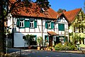
Hochstädten on the market square

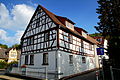
Cultural monument Mühltalstr. 266
Cultural monument Hochstädten Mühltalstr. 269

Cultural monument Mühltalstr. 272

Cultural monument Mühltalstr. 275
Cultural monument Mühltalstr. 277

Cultural monument Mühltalstr. 298

Hochstädter meadows and forests

View from the Friedensmal


Religious communities
- Evangelical parish of Bensheim-Auerbach and Hochstädten, with the mountain church in Auerbach
- Catholic parish " Heilig Kreuz " Bensheim-Auerbach and Hochstädten, with the Heilig-Kreuz-Kirche in Auerbach
societies
- KHV Hochstädten - Kerwe- und Heimatverein Hochstädten
- HSV Hochstädter sports club
- Hochstädten volunteer fire department
- Friedensmal turning point e. V.
Jerusalem Friedensmal

On a hill in the Hochstädten district, a memorial called the Jerusalem Friedensmal was erected on the initiative of Thomas Zieringer and the Friedensmal Wendpunkt association. It consists of the 26 m diameter Friedensmal, framed by a garden of freedom with a border stone bearing the inscription Yerushalayim. The Friedensmal is dedicated to the inner path and thus to a peace that one carries out into the world with one's speech and actions. In the middle of the Friedensmal you can find the rose of Shalom. The Hebrew word "Chai", which means to live, is inscribed in its flower.
The memorial shows a path to healing and new life in the awareness of suffering. The topic, which is also addressed on information boards on site, is the healing of a “root of our occidental culture” on a collective level and a path towards inner healing for people on an individual level. The monument design shows how both are interwoven.
The Jerusalem Friedensmal is located on the European long-distance hiking trail E8 between the Fürstenlager (Bensheim-Auerbach) and the Felsenmeer (Reichenbach). If you look from here to the west between the two hills in the Rhine plain, you can see the silhouette of the city of Worms with its large cathedral on the horizon. Worms is the geographical middle of the three ShUM cities Speyer, Worms and Mainz, which formed Jerusalem on the Rhine in the High Middle Ages.
Economy and Infrastructure

About 80 employees worked in the Hochstadt plant of Knauf Marmorit GmbH. Here, high-quality finishing plasters were produced and new products were tested in this area. The Marmorit plant started operations over 140 years ago. Since then, the main focus has been on the mining of marble in underground tunnels. The family company was sold in the seventies, and since the eighties it has belonged to the Knauf group of companies with headquarters in Bollschweil near Freiburg im Breisgau . On March 31, 2008, the Bensheim-Hochstädten location was closed after 143 years of factory history and the facility was scrapped. The demolition work on the former factory premises was completed in August 2009.
Web links
- High places. In: Website of the city of Bensheim.
- High cities. Local history, information. In: www.hochstädten.net. Private website
- Hochstädten, Bergstrasse district. Historical local dictionary for Hessen. In: Landesgeschichtliches Informationssystem Hessen (LAGIS).
- Literature on Hochstädten in the Hessian Bibliography
Individual evidence
- ↑ Bensheim in numbers (only residents with main residence). In: website. City of Bensheim, accessed July 2019 .
- ↑ a b City districts - Hochstädten. In: website. City of Bensheim, accessed on May 3, 2013 .
- ↑ a b c d e f g h Hochstädten, Bergstrasse district. Historical local lexicon for Hessen (as of May 20, 2018). In: Landesgeschichtliches Informationssystem Hessen (LAGIS). Hessian State Office for Historical Cultural Studies (HLGL)
- ^ A b c Georg Wilhelm Justin Wagner : Statistical-topographical-historical description of the Grand Duchy of Hesse: Province of Starkenburg . tape 1 . Carl Wilhelm Leske, Darmstadt October 1829, OCLC 312528080 , p. 113 ( online at google books ).
- ↑ Law on the Conditions of the Class Lords and Noble Court Lords of August 7, 1848 . In: Grand Duke of Hesse (ed.): Grand Ducal Hessian Government Gazette. 1848 no. 40 , p. 237–241 ( online at the information system of the Hessian state parliament [PDF; 42,9 MB ]).
- ^ Ordinance on the division of the Grand Duchy into circles of May 12, 1852 . In: Grand Ducal Hessian Ministry of the Interior (ed.): Grand Ducal Hessian Government Gazette 1852 No. 30 . S. 224–229 ( online at the Bavarian State Library digital [PDF]).
- ↑ Headlines from Bensheim on the 175th anniversary of the "Bergsträßer Anzeiger". (PDF; 9.0 MB) The creation of the Bergstrasse district. 2007, p. 109 , archived from the original on October 5, 2016 ; Retrieved February 9, 2015 .
- ↑ Headlines from Bensheim on the 175th anniversary of the "Bergsträßer Anzeiger" 2007. (PDF 8.61 MB) "Destruction through work". P. 79 , archived from the original on October 5, 2016 ; accessed on December 28, 2014 .
- ↑ Graves of Greek forced laborers at the Auerbach cemetery. ALSBACH TO LORSCH. Working group Zwingenberger Synagoge eV, accessed in December 2019 .
- ↑ Series of articles in the Bergstrasse Gazette from 2005 about the end of the war on Bergstrasse. Mountain road. Bergsträßer Anzeiger, accessed on December 20, 2014 .
- ↑ In Hochstädten there is a fear of a conflict among radicals. In: Bergsträßer Anzeiger from May 4, 2004. Archived from the original ; accessed in April 2019 .
- ^ Federal Statistical Office (ed.): Historical municipality directory for the Federal Republic of Germany. Name, border and key number changes in municipalities, counties and administrative districts from May 27, 1970 to December 31, 1982 . W. Kohlhammer, Stuttgart / Mainz 1983, ISBN 3-17-003263-1 , p. = 349 .
- ↑ a b main statute. (PDF; 69 kB) §; 6. In: Website. City of Bensheim, accessed February 2019 .
- ^ Michael Rademacher: German administrative history from the unification of the empire in 1871 to the reunification in 1990. State of Hesse. (Online material for the dissertation, Osnabrück 2006).
- ^ Grand Ducal Central Office for State Statistics (ed.): Contributions to the statistics of the Grand Duchy of Hesse . tape 1 . Großherzoglicher Staatsverlag, Darmstadt 1862, DNB 013163434 , OCLC 894925483 , p. 43 ff . ( Online at google books ).
- ↑ a b List of offices, places, houses, population. (1806) HStAD inventory E 8 A No. 352/4. In: Archive Information System Hessen (Arcinsys Hessen), as of February 6, 1806.
- ↑ Hessen-Darmstadt state and address calendar 1791 . In the publishing house of the Invaliden-Anstalt, Darmstadt 1791, p. 129 ( online in the HathiTrust digital library ).
- ↑ Hessen-Darmstadt state and address calendar 1800 . In the publishing house of the Invaliden-Anstalt, Darmstadt 1800, p. 134 ( online in the HathiTrust digital library ).
- ^ Ph. AF Walther : Alphabetical index of the residential places in the Grand Duchy of Hesse . G. Jonghaus, Darmstadt 1869, OCLC 162355422 , p. 40 ( online at google books ).
- ^ District monitoring. (PDF; 280 kB) Key figures Hochstädten. City of Bensheim, p. 25 , accessed July 2019 .
- ↑ Selected data on population and households on May 9, 2011 in the Hessian municipalities and parts of the municipality. (PDF; 1.8 MB) In: 2011 Census . Hessian State Statistical Office
- ^ Result of the local advisory board in Hochstädten 2016. In: Website. City of Bensheim, accessed December 2019 .
- ↑ Local Advisory Board 2016. In: Website. City of Bensheim, accessed December 2019 .
- ↑ Kerwe- und Heimatverein Hochstädten 1964 eV website.
- ^ Hochstädter Sportverein from 1978. Website.
- ↑ Hichstädten volunteer fire department. Website.
- ^ Association Friedensmal Wendpunkt e. V. Website.
- ↑ Garden of Freedom. In: website. Friedensmal Wendpunkt eV, accessed in September 2018 .
- ↑ Jerusalem on the Rhine. In: friedensmal.de. Accessed December 2019 .
- ↑ Marmorit-Werk invests in the Hochstädten location. In: morgenweb. Mannheimer Morgen, July 12, 2006, archived from the original ; accessed in 2008 .

Auerbach | Fehlheim | Gronau | Hochstädten | Long calves | Schoenberg | Schwanheim | Wilmshausen | Cell