
Langwaden (Bensheim)
|
||||||||||||||||||||||


Langwaden is a district of Bensheim in the Bergstrasse district in southern Hesse . Around 350 people live here.
geography
Langwaden is located in the Hessian Ried at an altitude of about 90 m above sea level . From a geological point of view, the area belongs to the old Neckar floodplain. The old bed of the Neckar ran between Langwaden and Hähnlein in the direction of Pfungstadt and flowed into the Rhine at Trebur . Bensheim city center is about 6.5 km as the crow flies in a south-easterly direction.
The Winkelbach coming from the Lautertal flows from the north around the place in the south and then flows in a westerly direction towards the Rhine .
The federal highway 67 runs in the immediate vicinity of Langwaden (west of the village). Rodau, which belongs to Zwingenberg, is 2 km to the east . Hähnlein is also 2 km away in the northeast . The Bensheim districts of Schwanheim and Fehlheim are located in the south and south-east, also about 2 km away (as the crow flies) . About 4 km separate Langwaden and Groß-Rohrheim in the west .
history
overview
The first written mention under the name Langwada is for Langwaden in the Lorsch Codex as property of the Lorsch Monastery under the year 773. In 1232 the monastery came to the Archbishopric of Mainz and in 1461 it was pledged to the Palatinate , which abolished the monastery in 1564. Most of the monastery's possessions fell to Kurmainz and the Count Palatine . From the east, the Erbach taverns tried to expand their territory and between 1417 and 1532 also came into possession of long-legged calves. In 1554 the Reformation is introduced in the county of Erbach and Langwaden belongs to the parish of Jugenheim . In 1621 the Erbachers sold the place for 20,000 guilders to Hessen-Darmstadt in order to obtain the ransom for Count Georg Albrecht I of Erbach (1597–1647). This was kidnapped by Turkish pirates on May 16, 1617 off Sicily and taken to Malta. For his release, 25,000 guilders - according to other sources 22,000 gold crowns - were demanded. As a result, Langwaden becomes a branch parish of Schwanheim . The place received its own church in 1698. The old town center was probably grouped around this church and the opposite town hall from the first half of the 18th century. Langwaden was certainly not spared from the Thirty Years' War , the plague and subsequent conflicts, such as the War of the Palatinate Succession , as was the entire Bergstrasse .
The statistical-topographical-historical description of the Grand Duchy of Hesse reported in 1829 about long calves:
»Langwaden (L. Bez. Bensheim) Lutheran Filialdorf; is 1 ⁄ 2 St. from Bensheim, has 1 chapel, 34 houses, and 216 inhabitants, who are Lutheran except for 1 Reform., 1 Catholic and 4 Jews. - The place already occurs in the 9th century; first belonged to the church of Jugenheim and became a branch of Schwanheim in the 17th century. In 1621 the place came to Hessen. "
The mayor's office is subordinate to the district of Bensheim . The judiciary is subject to the regional court of Zwingenberg , the financial administration is incumbent on the Rentamt Zwingenberg and the responsible tax administration is the tax district Bensheim with the main collection Bensheim with the district collection Gernsheim with Langwaden. The district of Bensheim with the Bickenbach secondary customs office is subordinate to the main customs office in Heppenheim . The forest district of Gernsheim with long calves is responsible for forest management. The Lutheran parishes are subordinate to the Bensheim Inspectorate and Catholic parishes in the district administration are subordinate to the Bergstäßer Landkapitel.
On February 1, 1971, the place was incorporated into Bensheim on a voluntary basis as part of the Hessian regional reform . For Langwaden, as for the other parts of the city, a local district with a local advisory board and local councilor was set up in accordance with the Hessian municipal code. The last mayor of Langwaden was Philipp Münster. A street in the Langwaden development area is named after him.
Origin of name
Langwaden is first mentioned as Lancquata in the Lorsch Codex 3671 ( Reichsurbar Gernsheim ) in 764 :
“ Hube de Gernesheim. In Gernesheim inueniuntur de terra arabili iurnales XCIII. In Lancquata iurnales XC. in Rorheim iurnales XL. "
(German translation: Farms of Gernsheim. In Gernsheim there are 93 days of arable land, in Langwaden 90 days, in Rohrheim 40 days.)
In 773 it became the name Langwatta . From 1640 the spelling Langwaden, which is common today, is in use. The first syllable stands for the German term long , that is, extended to the front and back; the opposite of short . The second part of the word waden comes from the Old High German wat (i) (ford, river crossing). The field name Waad denotes a "swampy place" and is derived from the Burgundian or Latin hereditary word vadum (= ford). The name of the place is thus derived as a ford through the Winkelbach . The Gernsheim field name Langwader Fahr from the 14th century confirms this.
Time of world wars
On August 1, 1914, the First World War broke out, which put an end to the positive economic development throughout the German Empire . When the armistice was signed after the German defeat on November 11, 1918, Langwaden also had casualties to mourn, while the war cost a total of around 17 million human lives. The end of the German Empire was thus sealed, and the troubled times of the Weimar Republic followed. In the period from 1921 to 1930, there were 566,500 emigrants in Germany who tried to escape the difficult conditions in Germany. On January 30, 1933, Adolf Hitler became Chancellor, which sealed the end of the Weimar Republic and the beginning of the National Socialist dictatorship.
On September 1, 1939, when German troops marched into Poland, the Second World War began , the effects of which were even more dramatic than the First World War and the number of victims estimated at 60 to 70 million people. The military airport near Biblis , which was repeatedly attacked by Allied air forces at the end of September 1944, caused bombs to fall on long legs. The intensified aerial warfare against Germany was particularly noticeable from 1944 onwards. Large air force units flew over Langwaden when they attacked the surrounding industrial cities of Ludwigshafen, Mannheim or Worms. In that year, work in the fields became life-threatening due to the continued low-flying attacks. Nobody was safe on the train or on the streets either.
In the final phase of the Second World War in Europe, the American units reached the Rhine between Mainz and Mannheim in mid-March 1945. The bridgeheads on the left bank of the Rhine could not be held by the weak German forces, which led to the demolition of the Rhine bridges at Worms, Nordheim and Gernsheim on March 20. The remnants of the German 7th Army, which had withdrawn to the right bank of the Rhine, had to leave almost all of their heavy equipment such as tanks and artillery behind, which made a continuation of the fighting with the absolute air supremacy of the Americans and the lack of any German reserves actually completely pointless. On the American side, the primary goal was now to avoid further losses, which led to the massive use of artillery, tanks and aircraft, even without precise knowledge of a possible counter-defense, on all cities and villages to be captured. If the advancing forces encountered resistance, there was an immediate retreat and massive use of the air force and artillery. On March 22nd, the 3rd US Army crossed the Rhine near Oppenheim and occupied Darmstadt on March 25th. From the American point of view, this made it necessary for the neighboring US 7th Army to move up quickly to secure its flanks. In preparation for their crossing of the Rhine, most of the Ried communities were shelled by American artillery on March 25th and on the night of March 26th. In the first hours of March 26, 1945, American troops crossed the Rhine near Hamm and south of Worms. On the same day you cross the Frankfurt – Mannheim motorway at Langwaden and stood in front of Schwanheim , which interrupted this important north-south connection. On March 27, the American units advanced further and stood in Lorsch, Bensheim, Heppenheim and Zwingenberg, a day later Aschaffenburg am Main and the western and northern parts of the Odenwald were occupied. The war in Europe ended with the unconditional surrender of all German troops, which came into effect on May 8, 1945 at 11:01 p.m. Central European Time.
Administration and courts
Langwaden belonged to the Upper County of Katzenelnbogen, which formed the core of the later Landgraviate of Hessen-Darmstadt . There Langwaden belonged to the "Amt Zwingenberg and Jägersburg" in the Upper County of Catzenellnbogen in the administrative district of Darmstadt until 1801 .
As a result of the Napoleonic Wars , the last session of the Perpetual Reichstag in Regensburg in February 1803 passed the Reichsdeputationshauptschluss , which implemented the provisions of the Peace of Lunéville and reorganized the territorial relations in the Holy Roman Empire (German Nation) . In it, the Landgraviate of Hessen-Darmstadt was awarded parts of the dissolved principalities of Kurmainz , Kurpfalz and Worms as compensation for lost areas on the right bank of the Rhine . The territory thus expanded east of the Rhine and south of the Main was led by Hessen-Darmstadt under the name of the Principality of Starkenburg .
Under pressure from Napoleon , the Rhine Confederation was founded in 1806 , this happened when the member territories left the empire at the same time. This led to the laying down of the imperial crown on August 6, 1806, with which the Old Empire ceased to exist. On August 14, 1806, the Landgraviate of Hesse-Darmstadt was raised by Napoleon to the Grand Duchy of France against high military contingents and membership of the Rhine Confederation , otherwise he was threatened with invasion. After the final defeat of Napoléon, the Congress of Vienna in 1814/15 regulated the territorial situation in Germany, the affiliation of the "Principality of Starkenburg" to the Grand Duchy was confirmed, after which the area was renamed the Province of Starkenburg . In 1820 the "Amt Zwingenberg and Jägersburg" was renamed to Amt Zwingenberg .
In 1821, as part of a comprehensive administrative reform, the district bailiffs in the provinces of Starkenburg and Upper Hesse of the Grand Duchy were dissolved and district councils were introduced, with Langwaden being assigned to the district of Bensheim . As part of this reform, regional courts were also created, which were now independent of the administration. The district court districts corresponded in scope to the district administration districts. This reform also regulated the administrative administration at the municipal level. The mayor's office in Langwaden was also responsible for Rodau . According to the municipal ordinance of June 30, 1821, there were no longer appointments of mayors , but an elected local council, which was composed of a mayor, aldermen and council.
In 1832 the units were enlarged one more time and circles were created. As a result, Langwaden came to the Bensheim district in August 1832 . In 1842 the tax system in the Grand Duchy was reformed and the tithe and the basic pensions (income from property) were replaced by a tax system of the kind that still exists today.
As a result of the March Revolution of 1848, with the "Law on the Relationships of the Classes and Noble Court Lords" of April 15, 1848, the special rights of the class were finally repealed. In addition, in the provinces, the districts and the district councils of the Grand Duchy were abolished on July 31, 1848 and replaced by "administrative districts", which was reversed on May 12, 1852, in the course of the reaction era. As a result, Langwaden belonged to the Heppenheim administrative district between 1848 and 1852 before the Bensheim district was again responsible for the higher-level administration.
The population and cadastral lists recorded in December 1852 showed for Langwaden: Filialdorf in the Rhine plain with 265 inhabitants. The district consists of 503 acres , including 341 acres of arable land, 132 acres of meadows and 3 acres of forest.
In the statistics of the Grand Duchy of Hesse, based on December 1867, the Langwaden with its own mayor's office, 38 houses, 208 inhabitants, the district of Bensheim, the district court of Zwingenberg, the Protestant parish of Schwanheim of the dean's office in Zwingenberg and the Catholic parish of Bensheim of the dean's office of Bensheim, specified.
The Hessian provinces of Starkenburg, Rheinhessen and Upper Hesse were abolished in 1937 after the provincial and district assemblies were dissolved in 1936. On November 1, 1938, a comprehensive regional reform came into force at the district level. In the former province of Starkenburg, the Bensheim district was particularly affected, as it was dissolved and most of it was added to the Heppenheim district. The district of Heppenheim also took over the legal successor to the district of Bensheim and was given the new name Landkreis Bergstrasse .
The Grand Duchy of Hesse was a member state of the German Confederation from 1815 to 1866 and then a federal state of the German Empire . It existed until 1919, after the First World War, the Grand Duchy for was republican written People's State of Hesse . In 1945 after the end of the Second World War , the area of today's Hesse was in the American zone of occupation and by order of the military government, Greater Hesse was created , from which the state of Hesse emerged in its current borders.
In 1961 the size of the district was given as 140 ha , of which 11 ha were forest.
On February 1, 1971, Langwaden was incorporated into Bensheim on a voluntary basis as part of the regional reform in Hesse . For Langwaden, a local district with a local advisory board and mayor was set up in accordance with the Hessian municipal code.
From 1821 the competent jurisdiction lay with the regional court of Zwingenberg . the district court of Zwingenberg emerged from it in 1879 . In 1934 the Zwingenberg District Court was dissolved and the tasks were transferred to the Bensheim District Court .
The following list gives an overview of the territories in which Langwaden was located and the administrative units to which it was subject:
- before 1479: Holy Roman Empire , County Katzenelnbogen , Upper County Katzenelnbogen , Amt Zwingenberg
- from 1479: Holy Roman Empire, Landgraviate of Hesse , Upper County of Katzenelnbogen, Amt Zwingenberg
- from 1567: Holy Roman Empire, Landgraviate of Hessen-Darmstadt , Upper County of Katzenelnbogen (1783: Amt Zwingenberg and Jägersburg )
- from 1803: Holy Roman Empire, Landgraviate Hessen-Darmstadt, Principality of Starkenburg , Amt Zwingenberg and Jägersburg
- from 1806: Confederation of the Rhine , Grand Duchy of Hesse , Principality of Starkenburg, Zwingenberg Office
- from 1815: German Confederation , Grand Duchy of Hesse, Province of Starkenburg , Zwingenberg Office
- from 1821: German Confederation, Grand Duchy of Hesse, Starkenburg Province, Bensheim District District (separation between the judiciary ( Zwingenberg District Court ) and administration)
- from 1832: German Confederation, Grand Duchy of Hesse, Starkenburg Province, Bensheim district
- from 1848: German Confederation, Grand Duchy of Hesse, administrative district of Heppenheim
- from 1852: German Confederation, Grand Duchy of Hesse, Province of Starkenburg, District of Bensheim
- from 1867: Grand Duchy of Hesse, Starkenburg Province, Bensheim district
- from 1871: German Empire , Grand Duchy of Hesse, Province of Starkenburg, Bensheim district
- from 1918: German Empire, People's State of Hesse , Starkenburg Province, Bensheim district
- from 1938: German Empire, People's State of Hesse, Bergstrasse district (In the course of the regional reform in 1938 , the three Hessian provinces of Starkenburg, Rheinhessen and Upper Hesse were dissolved.)
- from 1945: American zone of occupation , Greater Hesse , Darmstadt administrative district, Bergstrasse district
- from 1949: Federal Republic of Germany , State of Hesse , Darmstadt district, Bergstrasse district
- on February 1, 1971, Langwaden was incorporated into the city of Bensheim as a district.
Population development
| • 1629: | 11 house seats |
| • 1791: | 154 inhabitants |
| • 1800: | 148 inhabitants |
| • 1806: | 165 inhabitants, 29 houses |
| • 1829: | 216 inhabitants, 34 houses |
| • 1867: | 208 inhabitants, 38 houses |
| Langwaden: Population from 1791 to 2019 | ||||
|---|---|---|---|---|
| year | Residents | |||
| 1791 | 154 | |||
| 1800 | 148 | |||
| 1806 | 165 | |||
| 1829 | 216 | |||
| 1834 | 199 | |||
| 1840 | 208 | |||
| 1846 | 237 | |||
| 1852 | 265 | |||
| 1858 | 236 | |||
| 1864 | 234 | |||
| 1871 | 218 | |||
| 1875 | 216 | |||
| 1885 | 231 | |||
| 1895 | 210 | |||
| 1905 | 215 | |||
| 1910 | 212 | |||
| 1925 | 197 | |||
| 1939 | 170 | |||
| 1946 | 266 | |||
| 1950 | 211 | |||
| 1956 | 187 | |||
| 1961 | 206 | |||
| 1967 | 224 | |||
| 1970 | 266 | |||
| 1980 | ? | |||
| 1990 | ? | |||
| 2000 | ? | |||
| 2007 | 396 | |||
| 2010 | 352 | |||
| 2011 | 381 | |||
| 2015 | 342 | |||
| 2019 | 349 | |||
| Data source: Historical municipality register for Hesse: The population of the municipalities from 1834 to 1967. Wiesbaden: Hessisches Statistisches Landesamt, 1968. Further sources:; City of Bensheim :; 2011 census : | ||||
Religious affiliation
| • 1829: | 210 Lutheran (= 97.2%), one Catholic (= 0.64%), one Reformed (= 0.46%), 4 Jewish (= 1.85%) residents |
| • 1961: | 141 Protestant (= 68.45%), 63 Catholic (= 30.58%) residents |
politics
Local advisory board
There is a local district for Langwaden (areas of the former municipality of Langwaden) with a local advisory board and local mayor according to the Hessian municipal code . The local advisory board consists of five members. Since the local elections in 2016, he has five members of the “Wir für Langwaden” (WfL) electoral list. The head of the village is Philipp Ahlheim (WfL).
coat of arms
The local coat of arms was designed in 1956 according to the local seal that has been proven since 1621. The coat of arms was confirmed by the Hessian State Archives and is thus listed in the Hessian local register of arms.
The symbolism can be interpreted as follows: The blue place symbol in the middle of the coat of arms indicates the watercourses of the Rhine with its tributaries. This is typical for the Hessian Ried. The place symbol, designed as a three-pike, symbolizes Neptune and indicates an abundance of fish.
The two red stars in the coat of arms can also be found in the coat of arms of the Counts of Erbach-Erbach .
Sights and culture
building
The numerous half-timbered houses are worth seeing . There is a village community center, a sports field and a cemetery.
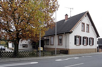
Village community center on Jägersburger Strasse
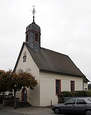
Langwaden Church
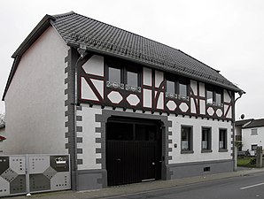
Half-timbered house in Jägersburger Strasse

Half-timbered houses in Jägersburger Strasse


Club life
In Langwaden there are five associations and two interest groups (IGs)
- Volunteer firefighter
- FC regular table "to Kathrin"
- German Red Cross
- Choral society "Liederkranz 1970".
- Long warmer notch e. V.
- Motorcycle get-together in Rohrlach
- IG "Christmas Market"
- The citizens' initiative livable Langwaden (BILL) belong to about 90 percent of the voting Langwadener citizens.
traffic
In the 2010 ADAC school bus test, route 676 between Bensheim and Langwaden performed worst in Germany. The route of the new Rhein / Main – Rhein / Neckar line of the Bahn AG , which is to connect the two existing new lines Cologne-Frankfurt and Mannheim-Stuttgart , is planned to be closely bundled with the BAB 67. This part of the NBS belongs to plan approval section 2, for which the initiation of plan approval is planned for 2011. The construction of the railway line is controversial; in the Langwader area, forest areas would be claimed by the project that take on recreational and noise protection functions.
literature
- Georg W. Wagner: Statistical-topographical-historical description of the Grand Duchy of Hesse: Province of Starkenburg. Volume 1, October 1829.
- Literature on long calves in the Hessian Bibliography
Web links
- Long calves. In: Website of the city of Bensheim.
- Langwaden, Bergstrasse district. Historical local dictionary for Hessen. In: Landesgeschichtliches Informationssystem Hessen (LAGIS).
Individual evidence
- ↑ a b c d e f g h Langwaden, Bergstrasse district. Historical local lexicon for Hesse (as of May 24, 2018). In: Landesgeschichtliches Informationssystem Hessen (LAGIS). Hessian State Office for Historical Cultural Studies (HLGL), accessed on May 27, 2018 .
- ↑ Bensheim in numbers (only residents with main residence). In: website. City of Bensheim, accessed July 2019 .
- ↑ Georg W. Wagner, p. 146.
- ^ A b Wilhelm Müller: Hessian book of place names - Starkenburg. Darmstadt 1937, pp. 419-420.
- ↑ a b H. Banse: Judith Brunner - an Odenwald woman - born in the Zurich Oberland. (PDF; 397 kB)
- ↑ Langwaden on bensheim-online.de, accessed on October 24, 2007 ( Memento from February 15, 2015 in the Internet Archive )
- ^ A b c Georg W. Wagner: Statistical-topographical-historical description of the Grand Duchy of Hesse: Province of Starkenburg . tape 1 . Carl Wilhelm Leske, Darmstadt October 1829, p. 88 ( online at Google Books ).
- ^ Bensheim and its districts. In: Bergstrasse Anzeiger. July 18, 2007.
- ↑ main statute. (PDF; 69 kB) §; 6. In: Website. City of Bensheim, accessed February 2019 .
- ^ Heinrich Tischner: Settlement names between the Rhine, Main, Neckar and Itter: Lorscher Codex 3671 (830/50). Retrieved October 25, 2007 .
- ^ Heinrich Tischner: settlement names between the Rhine, Main, Neckar and Itter: phonetic history of the South Hessian place names. Retrieved October 25, 2007 .
- ^ Heinrich Tischner: settlement names between the Rhine, Main, Neckar and Itter. Retrieved October 25, 2007 .
- ↑ Series of articles in the Bergstrasse Gazette from 2005 about the end of the war on Bergstrasse. Mountain road. Bergsträßer Anzeiger, accessed on December 20, 2014 .
- ↑ Wilhelm von der Nahmer: Handbuch des Rheinischen Particular-Rechts: Development of the territorial and constitutional relations of the German states on both banks of the Rhine: from the first beginning of the French Revolution up to the most recent times . tape 3 . Sauerländer, Frankfurt am Main 1832, OCLC 165696316 , p. 5 ( online at google books ).
- ^ M. Borchmann, D. Breithaupt, G. Kaiser: Kommunalrecht in Hessen . W. Kohlhammer Verlag, 2006, ISBN 3-555-01352-1 , p. 20 ( partial view on google books ).
- ↑ Law on the Conditions of the Class Lords and Noble Court Lords of August 7, 1848 . In: Grand Duke of Hesse (ed.): Grand Ducal Hessian Government Gazette. 1848 no. 40 , p. 237–241 ( online at the information system of the Hessian state parliament [PDF; 42,9 MB ]).
- ^ Ordinance on the division of the Grand Duchy into circles of May 12, 1852 . In: Grand Ducal Hessian Ministry of the Interior (ed.): Grand Ducal Hessian Government Gazette 1852 No. 30 . S. 224–229 ( online at the Bavarian State Library digital [PDF]).
- ↑ Wolfgang Torge : History of geodesy in Germany . Walter de Gruyter, Berlin, New York 2007, ISBN 3-11-019056-7 , pp. 172 ( partial view on google books ).
- ^ Ph. AF Walther : The Grand Duchy of Hessen: according to history, country, people, state and locality . G. Jonghaus, Darmstadt 1854, DNB 730150224 , OCLC 866461332 , p. 296 ( online at google books ).
- ↑ a b Ph. AF Walther : Alphabetical index of residential places in the Grand Duchy of Hesse . G. Jonghaus, Darmstadt 1869, OCLC 162355422 , p. 52 ( online at google books ).
- ↑ Headlines from Bensheim on the 175th anniversary of the "Bergsträßer Anzeiger". (PDF; 9.0 MB) The creation of the Bergstrasse district. 2007, p. 109 , archived from the original on October 5, 2016 ; Retrieved February 9, 2015 .
- ^ Municipal reform in Hesse: mergers and integrations of municipalities from June 21, 1971 . In: The Hessian Minister of the Interior (ed.): State Gazette for the State of Hesse. 1971 No. 28 , p. 1117 , item 988; Paragraph 23. ( Online at the information system of the Hessian State Parliament [PDF; 5.0 MB ]).
- ^ Federal Statistical Office (ed.): Historical municipality directory for the Federal Republic of Germany. Name, border and key number changes in municipalities, counties and administrative districts from May 27, 1970 to December 31, 1982 . W. Kohlhammer, Stuttgart / Mainz 1983, ISBN 3-17-003263-1 , p. 348 .
- ↑ a b main statute. (PDF; 69 kB) §; 6. In: Website. City of Bensheim, accessed February 2019 .
- ^ Michael Rademacher: German administrative history from the unification of the empire in 1871 to the reunification in 1990. State of Hesse. (Online material for the dissertation, Osnabrück 2006).
- ^ Grand Ducal Central Office for State Statistics (ed.): Contributions to the statistics of the Grand Duchy of Hesse . tape 1 . Großherzoglicher Staatsverlag, Darmstadt 1862, DNB 013163434 , OCLC 894925483 , p. 43 ff . ( Online at google books ).
- ↑ a b List of offices, places, houses, population. (1806) HStAD inventory E 8 A No. 352/4. In: Archive Information System Hessen (Arcinsys Hessen), as of February 6, 1806.
- ↑ Hessen-Darmstadt state and address calendar 1791 . In the publishing house of the Invaliden-Anstalt, Darmstadt 1791, p. 130 ( online in the HathiTrust digital library ).
- ↑ Hessen-Darmstadt state and address calendar 1800 . In the publishing house of the Invaliden-Anstalt, Darmstadt 1800, p. 134 ( online in the HathiTrust digital library ).
- ^ District monitoring. (PDF; 280 kB) Key figures long calves. City of Bensheim, p. 29 , accessed July 2019 .
- ↑ Selected data on population and households on May 9, 2011 in the Hessian municipalities and parts of the municipality. (PDF; 1.8 MB) In: 2011 Census . Hessian State Statistical Office
- ↑ Six acquaintances and a newcomer. In: Echo onlie. Echo Newspapers GmbH, accessed December 2019 .
- ^ Result of the local advisory board Langwaden 2016. In: Website. City of Bensheim, accessed December 2019 .
- ↑ Local Advisory Board 2016. In: Website. City of Bensheim, accessed December 2019 .
- ↑ New flag for long calves - the origin of the town's coat of arms clarified / 47 copies ordered. In: Bergstrasse Anzeiger. February 9, 2007.
- ↑ a b In the future, the ICE will rush 150 meters past long calves. In: Bergstrasse Anzeiger. February 16, 2007.
- ^ Rhein / Main-Rhein / Neckar: Link in the Trans-European Network. Retrieved on January 25, 2011 ( Memento from March 4, 2016 in the Internet Archive )

Auerbach | Fehlheim | Gronau | Hochstädten | Long calves | Schoenberg | Schwanheim | Wilmshausen | Cell