Lautertal (Odenwald)
| coat of arms | Germany map | |
|---|---|---|
|
Coordinates: 49 ° 43 ' N , 8 ° 42' E |
|
| Basic data | ||
| State : | Hesse | |
| Administrative region : | Darmstadt | |
| Circle : | Mountain road | |
| Height : | 200 m above sea level NHN | |
| Area : | 30.76 km 2 | |
| Residents: | 7157 (Dec. 31, 2019) | |
| Population density : | 233 inhabitants per km 2 | |
| Postal code : | 64686 | |
| Primaries : | 06254, 06251 (Elmshausen) | |
| License plate : | HP | |
| Community key : | 06 4 31 014 | |
| LOCODE : | DE LTL | |
| Address of the municipal administration: |
Nibelungenstrasse 280 64686 Lautertal (Odenwald) |
|
| Website : | ||
| Mayor : | Andreas Heun ( SPD ) | |
| Location of the community Lautertal (Odenwald) in the Bergstrasse district | ||
Lautertal (Odenwald) is a late 1971 newly created municipality in southern Hesse Bergstraße district in Odenwald . The seat of the municipal administration is the district Reichenbach .
geography
location
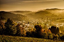
The Lauter valley begins at the source of the Lauter brook on the Neunkircher Höhe and in a westerly direction is initially wider, then quite narrow and steep up to the Bergstrasse , where the Lauter in Bensheim changes its name to Winkelbach . In addition, Lautertal has several mountain ranges on both sides of the actual valley.
Neighboring communities
Lautertal borders in the north on the communities of Seeheim-Jugenheim and Modautal in the Darmstadt-Dieburg district , in the east on the city of Lindenfels , in the south on the community of Fürth and the city of Heppenheim and in the west on the city of Bensheim .
Local division
Lautertal consists of the eleven districts Reichenbach (seat of the municipal administration), Lautern , Gadernheim , Raidelbach , Knoden with the hamlets of Breitenwiesen , Schannenbach , Elmshausen , Beedenkirchen , Staffel and the neighboring hamlets of Schmal-Beerbach and Wurzelbach .
history
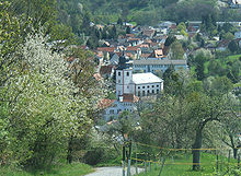
Church building
The municipality of Lautertal was created on December 31, 1971 as part of the regional reform in Hesse through the voluntary amalgamation of four previously independent municipalities: Elmshausen (without the Wilmshausen district ), Gadernheim (with Raidelbach , but without the Kolmbach district ), Lautern and Reichenbach , into which the municipality of Beedenkirchen (with relay ) was incorporated on the same day . On August 1, 1972, the municipalities of Knoden and Schannenbach and parts of the Reichenbach district belonging to the city of Bensheim were incorporated into the newly created municipality by law. On January 1, 1977, the hamlet of Schmal-Beerbach followed, which until then belonged to the Ober-Beerbach district and the Seeheim community ( Darmstadt district ).
For the districts of Reichenbach, Elmshausen, Lautern, Gadernheim, Raidelbach, Knoden with Breitenwiesen, Schannenbach and Beedenkirchen with Schmal-Beerbach, Staffel and Wurzelbach, a local district with a local advisory board and local councilor was set up in accordance with the Hessian municipal code.
The origins of the individual parts of the community are partly in Roman times (see Felsenmeer ) and in the Middle Ages (however, no remains of a castle near Gadernheim that was believed to have existed once existed).
The name of the community was officially changed to Lautertal (Odenwald) on July 1, 1980.
population
Population structure
According to the 2011 census , there were 7144 residents in Lautertal on May 9, 2011. Among them were 321 (4.5%) foreigners, of whom 170 came from outside the EU , 105 from other European countries and 46 from other countries. The inhabitants lived in 3,036 households. 822 of them were single households , 891 couples without children and 994 couples with children, as well as 270 single parents and 59 shared apartments . 4184 inhabitants belonged to the Protestant (48.6%) and 1256 inhabitants of the Catholic (17.6%) denomination.
Population development
| Lautertal: Population from 1970 to 2015 | ||||
|---|---|---|---|---|
| year | Residents | |||
| 1970 | 6,283 | |||
| 1976 | 6,693 | |||
| 1984 | 6,947 | |||
| 1992 | 7.182 | |||
| 2000 | 7,400 | |||
| 2005 | 7,325 | |||
| 2010 | 7.092 | |||
| 2011 | 7.144 | |||
| 2015 | 7.153 | |||
| Sources: see the following list | ||||
- In 1970, the municipalities united in the municipality of Lautertal had 6,283 inhabitants.
- In the local elections in 1977, as of June 1976, 6693 inhabitants were taken as the basis.
- In the local elections in 1985, as of June 30, 1984, 6947 inhabitants were assumed.
- In the local elections in 1993, as of March 31, 1992, 7182 residents were assumed.
- The Hessian community encyclopedia states for the year 2000: 7400 inhabitants.
- According to the Hessian State Statistical Office, 7,325 inhabitants lived in the Lautertal on June 30, 2005.
- The Hessian State Statistical Office reported for June 30, 2010: 7092 inhabitants.
- The 2011 census counted 7144 inhabitants.
- As of June 30, 2015, the Hessian State Statistical Office states 7153 inhabitants.
Gainful employment
The municipality in comparison with the district, administrative district Darmstadt and Hesse:
| year | local community | district | Administrative district | Hesse | |
|---|---|---|---|---|---|
| Employees subject to social security contributions | 2018 | 1138 | 75.286 | 1,740,388 | 2,584,005 |
| Change to | 2000 | + 18.7% | + 20.9% | + 19.2% | + 18.8% |
| of which full-time | 2018 | 62.3% | 70.6% | 72.6% | 71.5% |
| of which part-time | 2018 | 37.7% | 29.4% | 27.4% | 28.5% |
| Only marginally paid employees | 2018 | 476 | 15,568 | 222,301 | 369,892 |
| Change to | 2000 | −14.2% | −4.6% | + 8.1% | + 7.9% |
| Branch | year | local community | district | Administrative district | Hesse |
|---|---|---|---|---|---|
| Manufacturing | 2000 | 57.9% | 39.6% | 27.0% | 30.6% |
| 2018 | 38.7% | 32.0% | 20.4% | 24.3% | |
| Commerce, hospitality and transport | 2000 | 20.3% | 25.1% | 26.4% | 25.1% |
| 2018 | 26.4% | 25.8% | 24.7% | 23.8% | |
| Business services | 2000 | 5.4% | 11.6% | 25.1% | 20.2% |
| 2018 | 18.0% | 15.3% | 31.7% | 26.2% | |
| other services | 2000 | 15.4% | 22.0% | 20.1% | 22.5% |
| 2018 | 16.0% | 25.1% | 22.8% | 25.2% | |
| Other (or without assignment) | 2000 | 0.9% | 1.7% | 1.4% | 1.5% |
| 2018 | 0.9% | 1.1% | 0.3% | 0.4% |
politics
Community representation
The local elections on March 6, 2016 produced the following results, compared to previous local elections:
| Parties and constituencies |
% 2016 |
Seats 2016 |
% 2011 |
Seats 2011 |
% 2006 |
Seats 2006 |
% 2001 |
Seats 2001 |
||
|---|---|---|---|---|---|---|---|---|---|---|
| SPD | Social Democratic Party of Germany | 30.6 | 9 | 45.5 | 14th | 50.6 | 16 | 51.8 | 16 | |
| CDU | Christian Democratic Union of Germany | 27.6 | 9 | 33.6 | 11 | 33.7 | 10 | 30.8 | 10 | |
| GLL | Green List Lautertal | 10.6 | 3 | 17.1 | 5 | 6.4 | 2 | 7.1 | 2 | |
| LBL | Lautertal Citizens List | 31.2 | 10 | - | - | - | - | - | - | |
| UBL | Independent citizen council Lautertal | - | - | 3.8 | 1 | - | - | - | - | |
| FWGL | Free community of voters Lautertal | - | - | - | - | 7.0 | 2 | 10.3 | 3 | |
| FDP | Free Democratic Party | - | - | - | - | 2.2 | 1 | - | - | |
| total | 100.0 | 31 | 100.0 | 31 | 100.0 | 31 | 100.0 | 31 | ||
| Voter turnout in% | 58.7 | 53.8 | 54.3 | 59.2 | ||||||
mayor
Jürgen Kaltwasser (SPD) was the first directly elected mayor of Lautertal from 1996 to 2017. He was last re-elected on September 22, 2013 in the first ballot with 55.9 percent of the vote for a fourth six-year term. The turnout was 77.1 percent. On September 24, 2017, the non-party candidate Andreas Heun was elected as the new mayor with 56.2% of the votes cast. The turnout was 79.3%.
Karl Germann (SPD), who had previously been Mayor of Reichenbach since 1962, became the first mayor of the newly created Lautertal community. He was followed by Josef Weitzel (SPD), who held office from 1973 to 1985. The next incumbent was Gottfried Beyß (CDU) from 1985 to 1991. From 1991 to 1996 Josef Weitzel (SPD) returned as town hall chief.
Districts
The following local districts with local advisory board and local councilor according to the Hessian municipal code exist in the municipality:
- Reichenbach district (areas of the former Reichenbach community ). The local advisory board consists of seven members.
- Elmshausen district (areas of the former Elmshausen municipality ). The local advisory board consists of seven members.
- Lautern district (areas of the former Lautern municipality ). The local advisory board consists of seven members.
- Gadernheim district (areas of the former Gadernheim municipality ). The local advisory board consists of seven members.
- Raidelbach district (areas of the former Raidelbach community ). The local advisory board consists of seven members.
- Local district Knoden with Breitenwiesen (areas of the former municipality Knoden with Breitenwiesen ). The local advisory board consists of n members.
- District of Schannenbach (areas of the former municipality of Schannenbach ). The local advisory board consists of seven members.
- Local district of Beedenkirchen with Schmal-Beerbach, Staffel and Wurzelbach (areas of the former communities of Beedenkirchen , Schmal-Beerbach , Staffel and Wurzelbach ). The local advisory board consists of seven members.
badges and flags
coat of arms
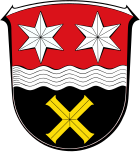
Blazon : “Shield divided; above a silver wavy bar (Lauter) in red two silver six-pointed stars, below in black a golden cross. "
The coat of arms of the municipality Lautertal was approved on July 19, 1974 by the Hessian Ministry of the Interior . It was designed by the Bad Nauheim heraldist Heinz Ritt .
The stars in the upper area of the coat of arms have their origin in the coat of arms of the princes of Erbach-Schönberg . The wavy ribbon is supposed to symbolize the Lauter river , which flows through Lauter Valley, and the inclined cross in the lower coat of arms is the cross of St. Andrew , to whom the church in Reichenbach , built in 1426, was dedicated.
flag
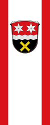
The flag was approved by the Hessian Ministry of the Interior on March 3, 1975 and is described as follows:
"In the widened white central track the red-white-red flag cloth, the municipal coat of arms."
Twin cities
- Parish of Aldenham ( England ), since October 25, 1980
- Jarnac ( France ), since September 4, 1982
- Dogliani , Piedmont , Italy
Culture and sights
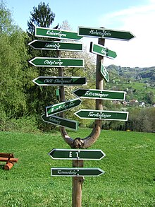
The Geo-Naturpark Bergstrasse-Odenwald is a local recreation area for numerous day-trippers in the densely populated Rhine-Main and Rhine-Neckar regions . In addition to numerous local hiking trails, the European long-distance hiking trails E1 and E8 cross in Lautertal . The Nibelungensteig , a 130 kilometer long long- distance hiking trail certified with the quality seal “Quality Walkable Germany” , also leads through the community.
Sea of rocks
The nationally known Felsenmeer on Felsberg above the Reichenbach district is popular with families and hikers . It is a mountain slope covered with rounded granite blocks, which children can easily climb through. The Romans used the sea of rocks as a granite quarry . The so-called giant column is evidence of this.
Hohenstein and Borstein
In the district of Reichenbach there are two climbing rocks recognized by the German Alpine Association , the 17 m high Hohenstein and the 8 m high Borstein at the Waldgasthaus Am Borstein, a former house for friends of nature . Both rocks also have ascent options with a low level of difficulty and are used by many climbing courses.
Historic houses
Several districts have preserved their old half-timbered town houses , mostly from the 16th to 17th centuries. Century: Elmshausen with the half-timbered town hall built in 1777, Reichenbach and Gadernheim (where the local history museum is now housed). In Gadernheim there was a forge as early as 1608 , today the oldest building in the Lautertal and one of the oldest unchanged forges in Hesse. However, it is in poor condition and will probably not be sustainable for much longer.
Imperial Tower
On the Neunkircher Höhe, the 34 m high imperial tower was built as a lookout tower in 1906/07 . From the tower the view falls over the Odenwald as well as to the Hessischer Ried , the Palatinate , Frankfurt am Main and the Taunus .
Evangelical parish church Gadernheim
In 1912/1913 the famous Art Nouveau architect Heinrich Metzendorf built this large church in the so-called Heimatstil . Located on the highest hill in the village, it dominates the upper Lautertal. It is a hall church with a sprawling polygonal apse and a facade tower, all covered with steep roofs. On the outside, the church shows mainly granite and - separated from it - sandstone elements . The upper part of the facade and the tower is covered with gray-blue painted wooden shingles. The furnishings ( stalls , pulpit altar ) have been preserved from the time it was built.
Striethteich Elmshausen
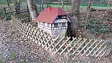
The local recreation area Striethteich in Elmshausen was created around 40 years ago by the Elmshausen Beautification Association from a swamp area. The pond provides a good habitat for water birds that have their own small island in the pond. In the immediate vicinity there is a small shelter and a small, water-powered model of the Deichertsmühle. Every year on Ascension Day there is a spring festival organized by the Elmshausen Beautification Association and the Elmshäuser Kerwejugend.
Economy and Infrastructure
Land use
The municipal area covers a total area of 10,200 hectares, of which in hectares are:
| Type of use | 2011 | 2015 | |
|---|---|---|---|
| Building and open space | 642 | 646 | |
| from that | Living | 305 | 309 |
| Business | 139 | 142 | |
| Operating area | 34 | 35 | |
| from that | Mining land | 6th | 6th |
| Recreation area | 142 | 141 | |
| from that | Green area | 40 | 40 |
| traffic area | 559 | 569 | |
| Agricultural area | 5139 | 5115 | |
| from that | moor | 0 | 0 |
| pagan | 0 | 0 | |
| Forest area | 3571 | 3574 | |
| Water surface | 53 | 55 | |
| Other use | 61 | 65 | |
Kindergartens
- Beedenkirchen Evangelical Kindergarten. Hechlergasse, Lautertal-Beedenkirchen
- Evangelical Kindergarten Elmshausen. Buchwaldstrasse 2, Lautertal-Elmshausen
- Evangelical kindergarten "Noah's Ark" Gadernheim. Kirchstrasse 16, Lautertal- Gadernheim
- Evangelical kindergarten "Drosseln & Finken" Lautern. Löserweg 12, Lautertal-Lautern
- Protestant day care center in Reichenbach. Knodener Strasse 32, Lautertal-Reichenbach
- Reichenbach natural kindergarten. On the Binn, Lautertal-Reichenbach
schools
- Elmshausen primary school. Nibelungenstrasse 42, Lautertal-Elmshausen
- Center school Gadernheim (elementary, secondary, secondary school). Heidenbergstrasse 18 Lautertal-Gadernheim
- "Felsenmeerschule" Reichenbach (elementary school). Knodener Strasse 1, Lautertal-Reichenbach
Individual evidence
- ↑ Hessian State Statistical Office: Population status on December 31, 2019 (districts and urban districts as well as municipalities, population figures based on the 2011 census) ( help ).
- ^ Municipal reform in Hesse: amalgamation and structure of municipalities of December 29, 1971 . In: The Hessian Minister of the Interior (ed.): State Gazette for the State of Hesse. 1972 No. 3 , p. 84 ff ., point 93, no. 84 ( online at the information system of the Hessian state parliament [PDF; 6.0 MB ]).
- ↑ Law on the reorganization of the Bergstrasse district (GVBl. II 330–15) of July 11, 1972 . In: The Hessian Minister of the Interior (ed.): Law and Ordinance Gazette for the State of Hesse . 1972 No. 17 , p. 222 ff ., § 1 ( online at the information system of the Hessian state parliament [PDF; 1,2 MB ]).
- ↑ Law on the reorganization of the districts of Darmstadt and Dieburg and the city of Darmstadt (GVBl. II No. 330–334 § 17) of July 26, 1974 . In: The Hessian Minister of the Interior (ed.): Law and Ordinance Gazette for the State of Hesse . 1974 No. 22 , p. 318 ff . ( Online at the information system of the Hessian State Parliament [PDF; 1.5 MB ]).
- ↑ Karl-Heinz Meier barley, Karl Reinhard Hinkel: Hesse. Municipalities and counties after the regional reform. A documentation . Ed .: Hessian Minister of the Interior. Bernecker, Melsungen 1977, DNB 770396321 , OCLC 180532844 , p. 211 .
- ↑ a b main statute. (PDF; 22 kB) §; 5. In: Website. Lautertal community, accessed in January 2020 .
- ^ Federal Statistical Office (ed.): Historical municipality directory for the Federal Republic of Germany. Name, border and key number changes in municipalities, counties and administrative districts from May 27, 1970 to December 31, 1982 . W. Kohlhammer, Stuttgart / Mainz 1983, ISBN 3-17-003263-1 , p. 350 .
- ↑ a b Population according to nationality groups: Lautertal (Odenwald). In: Zensus2011. Bavarian State Office for Statistics , accessed in July 2015 .
- ^ Households by family: Lautertal (Odenwald). In: Zensus2011. Bavarian State Office for Statistics , accessed in July 2015 .
- ↑ Religious affiliation : Lautertal (Odenwald). In: Zensus2011. Bavarian State Office for Statistics , accessed in July 2015 .
- ^ Lautertal, Bergstrasse district. Historical local dictionary for Hessen. (As of June 1, 2018). In: Landesgeschichtliches Informationssystem Hessen (LAGIS).
- ↑ Local elections 1977; Relevant population figures for the municipalities as of December 15, 1976 . In: The Hessian Minister of the Interior (ed.): State Gazette for the State of Hesse. 1976 No. 52 , p. 2283 , point 1668 ( online at the information system of the Hessian state parliament [PDF; 10.3 MB ]).
- ^ Local elections 1985; Relevant population of the municipalities as of October 30, 1984 . In: The Hessian Minister of the Interior (ed.): State Gazette for the State of Hesse. 1984 No. 46 , p. 2175 , point 1104 ( online at the information system of the Hessian state parliament [PDF; 5.5 MB ]).
- ↑ local elections 1993; Relevant population of the municipalities as of October 21, 1992 . In: The Hessian Minister of the Interior (ed.): State Gazette for the State of Hesse. 1992 No. 44 , p. 2766 , point 935 ( online at the information system of the Hessian state parliament [PDF; 6.1 MB ]).
- ↑ a b municipality data sheet : Lautertal. (PDF; 222 kB) In: Hessisches Gemeindelexikon. HA Hessen Agency GmbH
- ^ The population of the Hessian communities (June 30, 2005). In: Hessian State Statistical Office . Archived from the original .
- ^ The population of the Hessian communities (June 30, 2010). In: Hessian State Statistical Office . Archived from the original .
- ^ The population of the Hessian communities (June 30, 2015). In: Hessian State Statistical Office . Archived from the original .
- ^ Result of the municipal elections on March 6, 2016. 431014 Lautertal (Odenwald). Hessian State Statistical Office, accessed in April 2016 .
- ^ Result of the municipal election of March 27, 2011. 431014 Lautertal (Odenwald). Hessian State Statistical Office, accessed in November 2019 .
- ^ Result of the municipal election of March 26, 2006. 431014 Lautertal (Odenwald). Hessian State Statistical Office, accessed in November 2019 .
- ↑ Results of the municipal elections of 2001 and 1997. (No longer available online.) Hessian State Statistical Office, archived from the original ; accessed in October 2019 .
- ↑ Mayoral elections in Lautertal. Hessian State Statistical Office , accessed in January 2020 .
- ↑ Mayoral elections in four municipalities in southern Hesse. In: Echo Online. September 24, 2017 .
- ^ Beautification Association Reichenbach 1974: Vom Schultheiß, Mayor and Mayor ( Memento from December 26, 2015 in the Internet Archive )
- ↑ Approval of a coat of arms for the Lautertal community, Bergstrasse district dated August 19, 1974 . In: The Hessian Minister of the Interior (ed.): State Gazette for the State of Hesse. 1974 No. 31 , p. 1373 , point 987 ( online at the information system of the Hessian state parliament [PDF; 7.1 MB ]).
- ^ Approval of a flag for the Lautertal community, Bergstrasse district from March 3, 1975 . In: The Hessian Minister of the Interior (ed.): State Gazette for the State of Hesse. 1975 No. 12 , p. 508 , item 413 ( online at the information system of the Hessian state parliament [PDF; 7.5 MB ]).
- ↑ Information on the Striethteich. In: Departure and arrival in the Odenwald. Private website, archived from the original on August 28, 2018 ; accessed in January 2020 .
- ↑ Striethteich. In: website. Lautertal community, accessed in January 2020 .
- ↑ Hessisches Statistisches Informationssystem In: Statistics.Hessen.
- ↑ Kindergartens. In: website. Lautertal community, accessed in January 2020 .
- ↑ General education schools. In: website. Lautertal community, accessed in January 2020 .
literature
- Literature from and about Lautertal in the catalog of the German National Library
- Literature on Lautertal in the Hessian Bibliography
Web links
- Lautertal, Bergstrasse district. Historical local dictionary for Hessen. In: Landesgeschichtliches Informationssystem Hessen (LAGIS).
- Link catalog on Lautertal at curlie.org (formerly DMOZ )


