
Lauter (Rhine, Gernsheim)
|
Loud lower course: Winkelbach |
||
 The Lauter in Bensheim |
||
| Data | ||
| Water code | DE : 23954 | |
| location | Odenwald , Hessian Ried ; Circles mountain road and Gross-Gerau ; Hessen ( Germany ) | |
| River system | Rhine | |
| Drain over | Rhine → North Sea | |
| source | in the Odenwald at Neunkircher Höhe 49 ° 43 ′ 27 ″ N , 8 ° 45 ′ 52 ″ E |
|
| Source height | approx. 478 m above sea level NHN | |
| muzzle | near Gernsheim in the Upper Rhine Coordinates: 49 ° 45 ′ 7 ″ N , 8 ° 28 ′ 20 ″ E 49 ° 45 ′ 7 ″ N , 8 ° 28 ′ 20 ″ E |
|
| Mouth height | approx. 84.6 m above sea level NHN | |
| Height difference | approx. 393.4 m | |
| Bottom slope | approx. 12 ‰ | |
| length | 32.5 km | |
| Catchment area | 117.84 km² | |
| Discharge at the Bensheim A Eo gauge : 26.8 km² Location: 1.1 km above the mouth |
NNQ (07/30/1992) MNQ 1970/2009 MQ 1970/2009 Mq 1970/2009 MHQ 1970/2009 HHQ (07/11/1980) |
21 l / s 109 l / s 287 l / s 10.7 l / (s km²) 3.72 m³ / s 10.6 m³ / s |
| Medium-sized cities | Bensheim , Gernsheim | |
| Communities | Lautertal , Zwingenberg | |
The Lauter , called Winkelbach in the lower reaches , is a 32.4 km long, eastern and right tributary of the Rhine in southern Hesse . It rises in the Odenwald , flows in the Hessian districts of Bergstrasse and Groß-Gerau and flows into the Rhine near Gernsheim .
Names
From the source to Bensheim , the river is called Lauter . This section gave the river valley and the local community Lautertal its name. From Bensheim to its mouth near Gernsheim the body of water bears the name Winkelbach . This name is possibly explained by the bend the brook makes in Bensheim, or by its diversion near Rodau.
course


Odenwald
The Lauter rises in the Odenwald in the Geo-Naturpark Bergstrasse-Odenwald , in which it flows completely. Its source is about 2 km northeast of Gadernheim , a district of the Lautertal community, and 720 m northwest of Neunkircher Höhe ( 605 m above sea level ) at an altitude of 478 m .
Initially, the Lauter flows along the Weinweg as a trickle southwest down to Gadernheim. From there it runs along federal road 47 ( Nibelungenstraße ) westwards to and through the Lautern district of Lautern . Then it turns to the southwest and flows, immediately after flowing through a flood retention basin , through Reichenbach , the capital of the Lautertal community. It continues along the B 47 through the Lautertal district of Elmshausen .
The Lauter then reaches the urban area of Bensheim , where it first flows through Wilmshausen and Schönberg , where there is another retention basin. Then she reaches the Bensheim core city and at the same time leaves the Vorderen Odenwald .

Hessian Ried
In Bensheim the flowing water reaches the natural area Bergstrasse under the name Winkelbach , and then takes the route in the Upper Rhine Plain through the Hessian Ried . After reaching the Rinnentorturm (Rinnentor) on the south-western edge of Bensheim's old town , where the Neue Graben branches off, the river bends almost at right angles to the north from its previous south-westerly direction. It then disappears for about 1.2 km in an underground canal in which it crosses the B 3 ( Bergstrasse ) and which it leaves after the junction of Fehlheimer Strasse and Mozartstrasse . Shortly afterwards the brook crosses the Main-Neckar Railway . The Winkelbach is largely regulated.
Then the Winkelbach runs for several kilometers parallel to the federal motorway 5 in the north-northwest direction. To the west of the Bensheim district of Bensheim-Auerbach , which is remote from the stream, the Auer flows into the east . To the southeast of the Zwingenberg district of Rodau , which is also remote from the stream, the Winkelbach crosses under the A 5. Shortly afterwards, the stream passes the Niederwaldsee lake to the west. The Scheidgraben joins a little further north-northwest, where the stream bends to the west and then flows northwest parallel to the Lindenbruchgraben (Mühlgraben and Mittelgraben) to the southwest. The Schwanheimer Grenzgraben (Mühlgraben) , which had been fed by the Lindenbruchgraben shortly before, flows south of the Langwaden district of Bensheim , which the brook has passed .
300 m further north-west, the Winkelbach passes under the federal highway 67 . Another 4.4 km downstream in the Gernsheim city area , it passes the pilgrimage church of Maria Einsiedel to the north . The stream then crosses under the Darmstadt – Worms (Riedbahn) railway line and flows north past Klein-Rohrheim . He crosses under the B 44 .
The last section of the Winkelbach leads west past the core town of Gernsheim. 700 meters before the mouth, the Himmschlingsgraben (Langer Graben) flows in from the south as the last tributary . The confluence with the Rhine is about 50 m southwest of the Gernsheimer Rheinbrücke, which was destroyed in World War II .
Catchment area, tributaries and branch
Catchment area
The catchment area of the Lauter (Winkelbach) together with the Winkelbach is 117.84 km². The Obere Lauter has a catchment area of 27.49 km² from the river source to the kink of the flowing water in Bensheim and is 14 km long. Its water body number is 23954.2. The river section called Winkelbach begins in Bensheim, has the water body number 23954.1, is 18.4 km long and drains a further 90.35 km².
Tributaries
The tributaries of the Lauter (Winkelbach) include, viewed downstream (according to the individual records mentioned in the table header):
| Surname | page | Length ( km ) |
Source | Muzzle | Estuarine location ( Location ) |
Mu stat. ( km ) |
EZG ( km² ) |
GKZ |
|---|---|---|---|---|---|---|---|---|
| height ( m above sea level ) | ||||||||
| In the salt trough | Left | 1.8 | 424 | 365 | Gadernheim (i) | 30.4 | 23954-112 | |
| Bach from Geisberg | right | 1.1 | 331 | 295 | Lautern (i) | 28.6 | 23954-116 | |
| Vorbach | Left | 2.25 | 427 | 208 | Reichenbach (i) | 26.4 | 23954-1314 | |
| Frankbach | right | 1.25 | 325 | 203 | Reichenbach (i) | 26.15 | 23954-1316 | |
| Grautbach | right | 2.9 | 347 | 195 | Reichenbach (i) | 25.55 | 23954-1318 | |
| Reichenbach | Left | 2.25 | 432 | 193 | Reichenbach (i) | 25.45 | 23954-1392 | |
| Auer (Mühlbach / Ziegelbach) | right | 6.65 | 279 | 94 | Bensheim (u) | 15.1 | 8.19 km² | 23954-4 |
| Scheidgraben | right | 3.4 | 98 | 92 | Rodau (g) | 11.95 | 23954-622 | |
| Himmschlingsgraben (Langer Graben) | Left | 6.1 | 87 | 86 | Gernsheim (g) | 0.7 | 23954-92 | |
| Abbreviations (position) : u = below the point of the mouth; i = at the mouth; g = across from the muzzle | ||||||||

Branch
From the Winkelbach, the 4.1 km long Neue Graben branches off to the west at the Bensheimer Rinnentorturm (Rinnentor) on the upper weir . The trench water initially flows 1.3 km in an underground channel under Schwanheimer Strasse . From the intersection with the Berliner Ring it runs again as surface water . The ditch flows into the Weschnitz north of Lorsch and a little below the Wattenheim bridge .
Level measuring point Bensheim
At the eastern entrance to Bensheim is the Bensheim level measuring point with a level zero point of 105.38 m . The high water level for reporting level 1 is 80 cm, for level 2 at 100 cm and for level 3 at 120 cm. At 149 cm, the highest level was measured on July 11, 1980; this corresponds to a flow rate of 10.6 m³ / s.
history

The names Ziegelbach and Luitra were also used for the Lauter .
The Winkelbach was regulated, significantly expanded and deepened between 1833 and 1836. Two mills operated in Gernsheim were eliminated. This could be an indication that the artificially created river course to the west occurred around the year 600 AD , when the Modau was also being expanded.
However, there were still floods in the Winkelbach area after that, which led to the establishment of the “Lauter-Winkelbach Association” in 1966. Under his sponsorship not only safety measures were taken on the watercourse, but also two flood retention basins in the Odenwald and two more in the Ried plain. On January 1, 2001, the “Weschnitz Association” and the “Lauter-Winkelbach Association” merged to form the “Bergstrasse Water Association”, which is now responsible for all flood protection measures in Weschnitz, Lauter and Modau.
Like the Odenwald rivers Modau and Weschnitz , the Lauter / Winkelbach has now been regulated to protect against flooding to such an extent that flooding can almost be ruled out. This was intended to secure commercial locations near the Rhine.
Picture gallery
Pictures of the Lauter / Winkelbach in the direction from the source to the mouth

The retention basin on the Lauter in Schönberg

At the Bensheimer Rinnentor , the Neue Graben branches off from the waters called Winkelbach from there
The Winkelbach after a 1.2 km underground tour through Bensheim

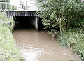
The confluence of the Winkelbach in the Rhine near Gernsheim


literature
- A. Lantos: The blue factory and its ecological consequences for the Lautertal / Odw .: Documentation for safeguarding contaminated sites by Ciba-Geigy. In: Geschichtsblätter Kreis Bergstrasse 28/1995, pp. 296–318. ISSN 0720-1044
Web links
- Water map service of the Hessian Ministry for the Environment, Climate Protection, Agriculture and Consumer Protection ( information )
- Water profile and program of measures 23954.1 ( Memento from January 1, 2013 in the web archive archive.today ) ( Notes ) → Overview of all Hessian river systems (PDF, 1.7 MB) Unterer Winkelbach
- Water profile and program of measures 23954.2 ( Memento from January 1, 2013 in the web archive archive.today ) ( Notes ) → Overview of all Hessian river systems (PDF, 1.7 MB) Oberer Winkelbach
- Overview map of Modau and the surrounding area with water body numbers. (No longer available online.) Formerly in the original ; accessed on February 12, 2017 . ( Page no longer available , search in web archives ) (PDF file; 4.73 MB)
- Map for level information of southern Hessian waters (the Lauter is drawn directly above the Weschnitz)
- Level near Bensheim on the HLUG side
Individual evidence
- ↑ a b c d Map services of the Federal Agency for Nature Conservation ( information )
- ↑ a b c d e f g h Water map service of the Hessian Ministry for the Environment, Climate Protection, Agriculture and Consumer Protection ( information )
- ^ BUND statement on the implementation of the Water Framework Directive in Hesse , dated September 10, 2004 (PDF; 87 kB); with obviously false value
- ^ German Hydrological Yearbook Rhine Region, Part I 2009 State Institute for Environment, Measurements and Nature Conservation Baden-Württemberg, p. 138, accessed on January 22, 2016 (PDF, German, 1.85 MB).
- ^ Settlement names between the Rhine, Main, Neckar and Itter , accessed on June 21, 2007, from heinrich-tischner.de
- ↑ Rivers kilometrage of the Lauter (Winkelbach) and estuary (Mü-Stat.) From the above inflow table according to the water map service of the Hessian Ministry for the Environment, Climate Protection, Agriculture and Consumer Protection ( information )
- ↑ For a better overview and sorting downstream, a hyphen has been inserted for each river in the water code number (GKZ) after the number “23954”, which stands for the Lauter (Winkelbach) .
- ↑ Level measuring point Bensheim (measuring point number 23950104), Hessian State Office for Nature Conservation, Environment and Geology , on hlnug.de
- ↑ The current water levels of the Lauter in Bensheim , Hessian State Office for Environment and Geology , on hlug.de
- ↑ Historical-topographical-statistical description of the Principality of Lorsch , or Church history of the Upper Rhine Valley: History and Statistics of the Monastery and Principality of Lorsch, etc, Konrad Dahl, 1812, pp. 167, 217, 251, on books.google.de
- ↑ Georg W. Wagner: Statistical-topographical-historical description of the Grand Duchy of Hesse: Province Starkenburg, volume October 1 , 1829, p. 264 ( online at Google Books )
- ^ Settlement names Lauter (n), Lauterbach, -tal, -hof , on heinrich-tischner.de
- ↑ Sound history of the South Hessian place names , on heinrich-tischner.de
- ↑ Georg Heil: There is a lot of water in the Ried - in the present and for millions of years ( Memento of October 13, 2007 in the Internet Archive ), in the Internet Archive, accessed on October 13, 2007
- ↑ Headlines from Bensheim on the 175th anniversary of the "Bergsträßer Anzeiger" 2007. (pdf 8.61MB) Damage from flooding. P. 40 , archived from the original on October 5, 2016 ; accessed on December 28, 2014 .
- ↑ Michael Stey: Multimedia processing of water management specialist information on the basis of a web-based content management system (WCMS) . In-depth work. Institute for Numerical Methods and Computer Science in Civil Engineering, TUD, Darmstadt 2003, p. 123 .