
Weschnitz
| Weschnitz | ||
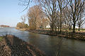
 The course of the Weschnitz |
||
| Data | ||
| Water code | EN : 2394 | |
| location | Germany , Hessen , Baden-Wuerttemberg | |
| River system | Rhine | |
| Drain over | Rhine → North Sea | |
| source |
Weschnitz spring north of Grasellenbach-Hammelbach in the Hessian Odenwald 49 ° 38 ′ 22 ″ N , 8 ° 49 ′ 43 ″ E |
|
| Source height | 455 m above sea level NN | |
| muzzle | at the Biblis nuclear power plant in the Rhine Coordinates: 49 ° 42 ′ 39 ″ N , 8 ° 24 ′ 16 ″ E 49 ° 42 ′ 39 ″ N , 8 ° 24 ′ 16 ″ E |
|
| Mouth height | 84.9 m above sea level NN | |
| Height difference | 370.1 m | |
| Bottom slope | 6.3 ‰ | |
| length | 58.9 km | |
| Catchment area | 435.725 km² | |
| Discharge at the Lorsch A Eo gauge : 383 km² Location: 16 km above the mouth |
NNQ (07/05/1976) MNQ 1956/2009 MQ 1956/2009 Mq 1956/2009 MHQ 1956/2009 HHQ (02/22/1970) |
500 l / s 1.17 m³ / s 3.23 m³ / s 8.4 l / (s km²) 24.6 m³ / s 48.7 m³ / s |
| Discharge A Eo : 435.725 km² at the mouth |
MNQ MQ Mq |
1.29 m³ / s 3.584 m³ / s 8.2 l / (s km²) |
| Left tributaries | Kröckelbach, Steinbach, Zotzenbach, Weschnitzmühlenkanal, Mörlenbach , Mumbach, Schimbach, Hornbach, Grambach, Kallstädter Bach, Grundelbach , Alte Weschnitz | |
| Right tributaries | Krumbach, Schlierbach, Linnenbach, Wiesentalbach, Ederbach, Liebersbach, Stadtbach, Meerbach , Neuer Graben | |
The Weschnitz is a 58.9 kilometer long right tributary of the Rhine in the south of Hesse and north of Baden-Württemberg .
River name
The name "Weschnitz" is traced back to Visucius , the name of a Celtic river god. Details are given at the Walpurgis Chapel in Fürth . This chapel stands at a former cult site of the Celts, and ore was mined nearby . Such chapels at old pre-Christian places of worship are not uncommon, one thinks of the Michaeliskapelle on the Heiligenberg near Heidelberg. Large stone crosses in the Odenwald are often an indication of a pagan site, because many menhir were carved into a cross after Christianization.
The Weschnitz is referred to with Wiscoz or similar spellings in numerous documents of the Lorsch Codex as a reference for the location of the Lorsch Monastery .
geography
course
The Weschnitz rises in the Odenwald , in the Hammelbach district of the Grasellenbach community , east of the 536 meter high Wagenberg . Its source is located on a signposted leisure area with a lake and barbecue hut. It first flows a short distance to the village of Weschnitz to the north and then turns along the B 460 in a U-bend to the southwest, breaking for two kilometers in a narrow notch valley between the 399 meter high Krehberg in the south and the 435 meter high Kohlwald in the north through the Tromm- Odenwald to reach Weinheim via Fürth and later along the B 38 via Rimbach , Mörlenbach and Birkenau . Between Fürth and Birkenau the Vordere Odenwald widens to the Weschnitzsenke. The area of the relatively soft and weather- prone granodiorite rock that predominates here has been named Weschnitzpluton after the river . In Weinheim, where the Weschnitz leaves the Odenwald and enters the Upper Rhine Plain, it bends in a new curve towards the northwest. It divides into two arms, the Alte Weschnitz and the Neue Weschnitz and thus forms the approximately 10-kilometer-long Weschnitzinsel , crosses under the B 3 and at Hemsbach the A 5 . It flows on to Lorsch , where its two arms meet again, runs a short distance again along the B 460 and then crosses the B 47 and the A 67 . It then reaches the communities of Einhausen and Biblis , and finally flows into the Rhine near the Biblis nuclear power plant .
The Weschnitz Valley Railway, named after the river, runs in the Odenwald section between Fürth and Weinheim .
Tributaries
- From the source to the mouth. In selection, especially from the river division in Weinheim. After this, the branches or the reunited run run to many almost parallel artificial trenches, which are often without proper proper names ("Neugraben", etc.). Longitudinal and catchment areas where listed according to LUBW-FG10 or LUBW-GEZG.
- Krumbach , from the right by the bath on the northern edge of Fürth .
- Kröckelbach , from the left in Fürth.
- Steinbach , from the left in Fürth.
- Schlierbach , from the right in Fürth, 8.391 km and 18.751 km².
- Fahrbach , from the left in Fürth- Fahrenbach .
- Lörzenbach , from the right on the northern edge of Rimbach .
- Rimbach , from the left in Rimbach.
- Albersbach , from the right on the southern edge of Rimbach.
- Zotzenbach , from the left northwest of Rimbach- Zotzenbach .
- Holzgraben or Breitenbacher Bach , from the right in Mörlenbach - Groß-Breitenbach .
- Erbach , from the left in Mörlenbach- Klein-Breitenbach .
- Mörlenbach , from the left in Mörlenbach , 9.344 km and 15.357 km².
- Bettenbach , from the right at Mörlenbach- Bettenbach .
- Mumbach , from the right to the Mörlenbach sewage treatment plant, 5.734 km.
- Schimbach , from the left in Birkenau - Reisen .
- Hornbach , from the left at Birkenau- Hornbach .
- Grambach , from the right in Birkenau.
- Liebersbach , from the right in Birkenau, 7,089 km.
- Kallstädter Bach , from the left in Birkenau, 6.742 km.
- Grundelbach , from the left in Weinheim , 10.864 km and 5.388 km².
- Exit on the left side of the Alte Weschnitz at Weinheimer Bahnhof, on the right the Weschnitz runs from here as Neue Weschnitz . Both branches soon flow between dams.
- Exit on the left from the Neue Weschnitz der Langen Wiese approximately at the level of Lampertheim - Hüttenfeld , which then runs for a long time between the two dammed branches.
- Neugraben , from right into Neue Weschnitz at the crossing of the L 3398 Heppenheim -Hüttenfeld, 9.331 km.
- Schwalbenzahl (Graben), from the right into the Neue Weschnitz , 1,334 km.
- Mouth of the Lange Wiese from the right into the Alte Weschnitz near Lorsch , 5.777 km.
- Confluence of the Alte Weschnitz into the Neue Weschnitz , shortly afterwards from the left, 12.665 km.
- Landgraben , from the left into the reunified Weschnitz shortly afterwards, 23.657 km. The most distant source under the Ursenbacher Höhe , the largest part of the course in the Rhine plain as a ditch.
- Meerbach , from the right shortly after the mouth of the Landgraben near Lorsch, 14 km and 21.622 km².
- Halbmaasgraben , from the left near Wattenheim , 6.894 km.
history
In ancient times , the Weschnitz in the Hessian Ried used the riverbed of the Ur- Neckar and flowed into the Rhine at Trebur , so much further north than today. Only in historical times did it get the current course by breaking through the dune hills near Lorsch; therefore it is canalised in the area of the Upper Rhine Plain ( Bergstrasse district ). The current Weschnitzlauf can be proven from the middle of the 17th century, previously the Weschnitz probably ran south of Lorsch, where it fed the Lorsch lake (at today's Seehof residential area ). Its mouth was up the Rhine from the late antique Rhine port of Zullestein , which therefore only lies on the Weschnitz after the castle was abandoned. Therefore it is never mentioned in historical sources as lying on the Weschnitz. The stream flowing there was called "Steiner Bach".
It is wrong to believe that the stone products from Felsberg and Auerbach were transported over the Weschnitz to the Rhine. Before the Tullas straightening at the mouth of the Weschnitz, the Rhine itself was not deep enough to B. to carry barges with the large granite pillars from Felsberg.
After the great floods with dam breaks in 1882/83, 1922 and 1955 at Weschnitz and Winkelbach , the Weschnitz Association was founded in 1958. As early as 1956, at the instigation of the Hessian state government, all drafts for a regulated flood discharge were compiled, first the Weschnitz and then the Lauter and Winkelbach. Between 1958 and 1970 a bundle of construction measures was carried out under the sponsorship of the Weschnitz Association. This ranged from dam elevations to the construction of six flood retention basins, five of them in the Odenwald and one in the reed. From the two water regulation associations Weschnitz and Lauter-Winkelbach emerged on January 1, 2001 the "Gewässerverband Bergstrasse". To protect the curlew was nature reserve Weschnitzinsel reported 1979th
In 2006/2007, the Weschnitzgraben was redesigned in the area of Einhausen. They left it with the previously deepened creek bed and the existing creek, but widened it a little and placed larger boulders as obstacles in the creek's path. Dams were also partially replanted to beautify the watercourse and its immediate surroundings. The intention with these changes was not so much to restore the stream to its original shape as to create an experience space in it, which is why the river bank was made accessible in some places. Since then, children can be seen playing by the water in summer.

In March 2007, the city of Lorsch began to renature the Weschnitz in the area below the Wattenheimer Bridge . Around 30,000 cubic meters of earth were moved for this purpose. The northern Weschnitz dam was dismantled so that a biotope could form. The renaturation, the cost of which was 470,000 euros, was done to compensate for the development of the Lorsch industrial area "Daubhart". The Weschnitz was given significantly more space to create meanders . Spawning sites have been created for the nasal fish that have settled there. Black poplars were replanted on the river bank . Archaeologists accompanied the construction work around the Wattenheim Bridge. They hoped for finds from the Celtic era, such as pottery shards and the remains of spearheads.
The water quality of the Weschnitz has improved noticeably in recent years. In the meantime, water quality has almost been achieved at the Wattenheimer Bridge.

Weschnitz Valley in the Odenwald from a satellite image
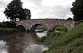
The Wattenheimer Bridge leads over the Weschnitz near Lorsch

View of the Weschnitzinsel from the northern tip of the nature reserve. Left the Neue Weschnitz and right the Alte Weschnitz.
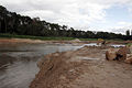
The renaturation measures started in March 2007 on the Weschnitz near Lorsch in June 2007
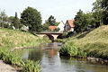
The newly designed stream of the Weschnitz in Einhausen
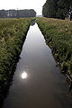
The straightened Weschnitz near Biblis

Map of the confluence of the Weschnitz in the Rhine.
The confluence of the Weschnitz in the Rhine. Biblis NPP in the background.

Flood of the Weschnitz in May 2013, town center Einhausen

Level of the Weschnitz near Lorsch


literature
- Sven-Hinrich Siemers, From the Carolingian trading settlement “Zullestein” to the fortress “Zum Stein” near Biblis-Nordheim, Bergstrasse district. An evaluation of the finds from the “Schloßbuckel” excavation from 1970 to 1972 (Mainz 2001 [2003]).
Individual evidence
- ↑ a b c Topographic map 1: 25,000
- ↑ a b c Map service for the implementation of the Water Framework Directive in Hesse
- ^ German Hydrological Yearbook Rhine Region, Part I 2009 State Institute for Environment, Measurements and Nature Conservation Baden-Württemberg, p. 137, accessed on January 22, 2016 (PDF, German, 1.85 MB).
- ↑ List of places for the Lorsch Codex, Weschnitz (river) , Archivum Laureshamense - digital, Heidelberg University Library.
- ↑ Headlines from Bensheim on the 175th anniversary of the "Bergsträßer Anzeiger" 2007. (pdf 8.61 MB) Damage from flooding. P. 40 , archived from the original on December 20, 2014 ; accessed on December 28, 2014 .
- ↑ Municipal information for the city of Lorsch ( Memento from September 28, 2007 in the Internet Archive )
- ↑ Bergsträßer Anzeiger from May 18, 2007 ( Memento of the original from September 27, 2007 in the Internet Archive ) Info: The archive link was inserted automatically and has not yet been checked. Please check the original and archive link according to the instructions and then remove this notice.
- ↑ Bergsträßer Anzeiger from April 19, 2007 ( Memento of the original from September 27, 2007 in the Internet Archive ) Info: The archive link was automatically inserted and not yet checked. Please check the original and archive link according to the instructions and then remove this notice.
- ↑ Echo-Online.de of January 24, 2007 ( Memento of September 26, 2007 in the Internet Archive )
Web links
- The Weschnitz from the source to the mouth , on Youtube.de
- Water profile and program of measures 2394.1 ( Memento from January 1, 2013 in the web archive archive.today ) ( Notes ) → Overview of all Hessian river systems (PDF, 1.7 MB) Untere Weschnitz
- Water profile and program of measures 2394.2 ( Memento from January 1, 2013 in the web archive archive.today ) ( Notes ) → Overview of all Hessian river systems (PDF, 1.7 MB) Obere Weschnitz
- Hessian State Office for Environment and Geology: Retention cadastre Weschnitz river area PDF file (5.16 MB)
- Level at Lorsch on the HLUG side
- Level at Fahrenbach on the HLUG side
-
Geoportal Baden-Württemberg ( information ), especially with the partial maps / layers
- the State Institute for the Environment, Measurements and Nature Conservation Baden-Württemberg (LUBW)
- "LUBW-FG10": River 1: 10,000
- "LUBW-GEZG": water catchment areas
- the State Institute for the Environment, Measurements and Nature Conservation Baden-Württemberg (LUBW)