
Weschnitzpluton

The Weschnitzpluton is the largest rock complex of the crystalline Odenwald . Its outcrop forms a triangle between Heppenheim , Weinheim and Reichelsheim with the eponymous Odenwälder Weschnitztal as the core area. It essentially consists of granodiorites , which crystallized in the late Lower Carboniferous around 333 to 329 million years ago, and thus represents a section of the Variscan mountain formation (see also → Geology of the Odenwald ).
The granodiorite of the Weschnitzplutons
The pluton , referred to as hornblende granite (Gh) in earlier mappings, is now classified as granodiorite, which was probably processed as " intrusive regenerate" from older stocks that existed before the mountain formation.
The gray-white stone consists mainly of the light mixture parts quartz , potassium feldspar and soda lime feldspar ( plagioclase ) and only a small part of dark mica ( biotite ) or hornblende . The average mineralogical composition is around 50% plagioclase, 20% quartz, 15% biotite, 10% potassium feldspar and 7% hornblende.


Such formations are still open in quarries where the granodiorite for building stones and road gravel was or is being mined: especially on both slopes of the Juhöhe z. B. at Nieder-Liebersbach , Kirschhausen , Wald-Erlenbach , Mitlechtern or Sonderbach , where at the northern foot of the Kohlplatte (Juhöhe) the Weschnitzpluton is interspersed with pegmatite and slate gneiss clods as well as lamprophyr and aplite passages.
Tectonic processes
Due to the continental drift, small continents and islands drifted towards each other in the Devonian and Carboniferous periods (around 380-320 million years ago). As a result of the compressions, rocks were sunk deep into the earth's crust ( subduction ) and melted at a depth of approx. 15 kilometers , and secondly - together with magma rocks - slowly pushed back up into the earth's crust, where they gradually cooled and crystallized over the course of 60 million years. This is how the Variscan Mountains came into being , to which the Odenwald belongs.
During the tectonic processes, crevices tore open again and again in the rock masses, into which melts penetrated and crystallized into gangue rocks , for example the kersantite passages on the Juhöhe on the slope to Bergstraße ( stone wall ) or the ore-bearing (e.g. copper, iron and manganese) barite - and hard quartz of the Hinkelstein west of Ober-Liebersbach . (see natural monuments in Weschnitzpluton ) Older granodiorite stocks were also rubbed through by younger aplit-like granites such as between Ober-Liebersbach and Bonsweiher .
In the specialist literature, both the origin of the various formations of the Crystalline Odenwald as well as the delimitations from the neighboring units in connection with the tectonic processes are discussed. There are different opinions regarding the delimitation of the southern granite and granodiorite complexes from the central → Flasergranitoidzone . Like Altherr, Willner (1991) and Krohe (1994) describe a fault zone ( strike-slip zone ) as the boundary between the Flasergranitoidzone and the Weschnitzpluton and emphasize the differences between the intrusion structures: In the southern part of the Bergstrasse Odenwald , the intrusions rise as large ones urgent plutons, whereas they mostly form a close and complex connection to the central region. Therefore, they divide the Bergstrasse Odenwald into two independent tectonic-metamorphic units ( unit 2 and unit 3 ). Stein, on the other hand, summarizes the Flasergranitoidzone with Weschnitzpluton , Trommgranit and → Heidelberg granite , since he could not determine a fault zone.
For this assumption speak u. a. Radiometric measurements by Kreuzer and Harre, Rittmann (1984) and Todt (1995). They show neither a significant time difference between the intrusions nor between the peaks of the metamorphoses in both units : 235 uranium / 207 lead and 238 uranium / 206 lead dating on zirconia of metamorphic rocks that arose from sediments of the central (336-337 million). Years) and the southern Bergstrasse Odenwald (342 million years, 332 million years) refer to thermal peaks of the regional metamorphosis. The subsequent cooling history is derived from potassium argon and 40 argon / 39 argon values from Hornblende (343-335 million years; 334 million years) and biotite (328-317 million years; 330 million years). Further evidence is listed under Flasergranitoidzone .
Today's landscape of the Weschnitz Valley
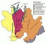
For several million years, the Weschnitzpluton has not formed a mountain range, but a spacious intramontane basin that is only bordered by a granodiorite ridge towards the edge of the Rhine rift. The majority of the mountains surrounding the Weschnitz Valley in the north, east and south belong to other geological units (see map):
- In southwest-northeast-directed running Flasergranitoidzone are mixing contact metamorphism melted old stocks (gneiss, schist) with granitoid intrusions, similar in granitoid-floes agglomerate between Wald-Michelbach and Weinheim.
- The ridge and its western slope consist of drum granites intruded around 320 million years ago .
- The Wachenberg near Weinheim is the remains of a volcanic vent made of rhyolite . About 260 million years ago, a volcano broke through the granite rocks that had already been removed down to a fuselage at an old fault zone in Ober-Rotliegend and near the current Rheingrabenbruch (more under Geology of the Odenwald ).
Today's varied landscape with the wavy crisscrossed peaks developed in the tertiary age . Triggered by the lowering of the Upper Rhine Rift 45 million years ago, tremors broke the area of today's Odenwald into mountain blocks and ditches. The continually sinking Rhine Valley also laid the erosion base for the Weschnitz and its side streams, which mostly bear the names of neighboring towns, deeper and deeper, so that the rivers increasingly cut into the rock. The greatest erosion took place in the Tertiary, while, for example, the Weschnitz near Fürth at the beginning of the Ice Age about 2 million years ago flowed less than 50 m above today's level (200 m above sea level), which is proven by the Old Pleistocene gravel. In the previous millions of years, the river had cut the Erzberg (475 - 484 m) area about 240 m and also the layers above that have now been cleared away.
In addition, the warm, humid climate of this time favored weathering. So not only the mighty red sandstone and shell limestone layers, which had deposited on the granite base of the mountains in the Mesozoic Era (more under Geology of the Odenwald ), were crushed and eroded by the rivers , but also the again exposed crystalline mountain hull.
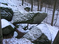
In this context the granite rock castles were created (see natural monuments in Weschnitzpluton ): The upper parts on the ridge of the Juhöhe were torn into blocks and the subsequent chemical weathering rounded them off ( wool sack weathering ). First, they were still surrounded by up to 30 m deep Vergrusung later rinsed rains the crus of the slopes (talus) and the valley, where it is conveyed away streams, and laid Granodioritfelsen free, partially in Auftauphasen end of the ice on the permafrost slid down the valley and formed boulder seas.
Barite quartz veins, like those of the Hinkelstein between Ober-Liebersbach and Balzenbach or the Steinböhl between Klein-Breitenbach and Groß-Breitenbach , withstood weathering more than the granodiorite surrounding them because of their hardness. That is why they were modeled as mountain ridges between the softer rocks .
Similar to the other granitoid units of the Bergstrasse Odenwald , only the eastern part of the Weschnitz pluton has probably been preserved. The rest of the pluton, together with the layers of sediment lying on it, is likely to have sunk up to 3.5 km (end of the Tertiary: up to 4 km) deep in the Rhine Trench than this, in connection with a rift zone from the Mediterranean to the North Sea, collapsed and was immediately filled up again and again by sliding down the surface and the weathered debris.

Weschnitzpluton heights with slate-diorite-flasergranitoid-gabbro-granite chains ( Krehberg - Neunkircher Höhe -Lindenfels), Gumpener Kreuz (WP) and Großes Köpfchen ( drum granite ) in the north (panorama: pictures 1–6)
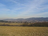
Weschnitzpluton hill (towards Rimbach, Fürth) with north-eastern drum granite chain ( Großes Köpfchen - Wagenberg )

Granodiorite landscape (towards Mörlenbach) with an adjacent drum granite chain to the east ( Schimmelberg - Götzenstein ) and the red sandstone Hardberg in the middle

Weschnitzpluton heights (towards Weinheim) with drum granite granodiorite ridge ( Götzenstein ) to Wachenberg (rhyolite)

Southwestern Weschnitzpluton region from the Tromm ( Auf der Lehen ). Background: Wachenberg (left) to Kreuz-Berg (right). Foreground: fields covered with G2 shards (clearing of the drum granite ), behind the hill of the drum granite- gneiss mixed zone between Mörlenbach and Stallenkandel

View from the Tromm ( Auf der Lehen ) to the west: over the Trommgranit slope and the Weschnitz valley to the Weschnitzpluton ridge of the Juhöhe ( Kreuz-Berg to Steigkopf )

Tromm granite and Weschnitzpluton areas from the Gumpener Kreuz : left to center right the Tromm-Wachenberg chain, on the right in the background the Juhöhe-Hirschkopf mountain range


Of the Variscan Weschnitzpluton massif, only the western mountain range and a wide, hilly basin eroded by the streams remained. Ice Age (diluvial) and post-Ice Age (alluvial) hanging areas and loess deposits lined the landscape and thus created the rounded shapes (see gallery) that determine the landscape in the extensive catchment area of the Weschnitz:
- The sources of the right tributaries Krumbach, Schlierbach, Linnenbach, Lörzenbach lie in the slate-diorite-gabbro-granite chains (Krehberg, Lindenfels ) to the north .
- (Albersbach), (Groß-Breitenbach), Bonsweiherer Ederbach and Liebersbach cut the western Juhöhe- Hirschkopf ridge.
- The streams coming from the east (Brombach), Kröckelbach, Steinbach, (Fahrenbach), (Rimbach), (Münschbach), Zotzenbach, Mörlenbach, Mumbach, Schimbach, Hornbach, Kallstädter Bach cut their way into the slopes of the Trommgranite or the mixed zone .
- The Weschnitz was only connected by retrograde erosion (between Brombach and Leberbach ) with its current upper course, which runs from the source at Hammelbach to the village of Weschnitz in a northerly direction at the border of the red sandstone step (in the east) and the intermediate zone (in the west) crosses. Originally this brook followed its old course to the north, into the Ostertal.

Notched erosion in the granodiorite near Klein-Breitenbach: headwaters of the Kleinbreitenbach on the western slope of the Taschengrube hill (297 m).

By copper - manganese - and iron admixtures brown-black-gray banded barite - quartz blocks of Hinkel stone between upper Liebersbach and Balzenbach.

The granodiorite rock Stennen Ros in the form of a horse lying on the eastern slope of the Kreuz mountain (between Hemsbach and Balzenbach) is mentioned as a border mark in a document from the Carolingian era as early as 805 .

According to a local version of the Rodensteiner legend , the pack of dogs that accompanied the ghost rider on his wild hunt through the air fell over the Juhöhe. Only the petrified heads stick out of the ground.
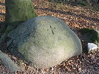
Granite blocks with carved crosses on the high path to the district forest were previously used as bearing stones (= boundary stones ).

Oval, loaf-shaped incisions gave a rock north of the Hirschkopf Tower near Weinheim the name Batzenbrotstein . Under the name of Hölzerlips -Stein , he supposedly commemorates a murder of the band of robbers at this point.


Natural monuments in the Weschnitzpluton
1. Granodiorite block formations
- Iron on the Wald-Erlenbacher slope of the Höhnberg (375 m) in the Juhöhe complex. About 1 km northwest of the Kreiswald car park (cliff hike: circular route 10) or southwest of the Wald-Erlenbach car park
- Sacrificial stones on the Juhöhe (Bodenwald, 361 m above sea level) on the way to the Kreiswald (approx. 1 km from the Frauenhecke car park )
- Whale on the Höhnberg south-east of Kirschhausen about 800 m north of the Kreiswald parking lot (object no. 431.11-42 in the list of natural monuments in the Bergstrasse district)
- Small sea of rocks about 600 m northeast of the Holzerne Hand car park on the Juhöhe (No. 431.11-91)
- Pfalzgrafenstein 150 m southwest of Lindenfels Castle (No. 431.15-42)
- Rock cliff 230 m north of the Krehberg transmission tower near Seidenbuch about 800 m northeast of the Schannenbacher Eck car park (No. 431.15-62)
- Stennen Ros in the shape of a horse about 800 meters north of the parking lot Schaumesklingel east of Hemsbach
- Bearing stone: granodiorite block with a carved cross to mark the border on the Juhöhe (Bodenwald, 361 m above sea level) on the way to the district forest
- former quarry at Saukopf near Weinheim
2. Dike rocks in the granodiorite
- Vogesitklotz in Kirschhausen (No. 431.11-24)
- Because of the mineral admixtures, black-brown-banded barite quartz blocks from the Hinkelstein between Ober-Liebersbach and Balzenbach
Granodiorite rock formation, called iron , on the Wald-Erlenbacher slope of the Höhnberg (Juhöhe complex)

Granodioritfelsburg (iron group) on the Wald-Erlenbach slope of the Höhnberg (375 m)

Granodiorite rock formation on the Höhnberg with typical weathering characteristics (crevices, weathering of wool sacks , gravel)

The sacrificial stones are granodiorite rocks with eroded bowl-shaped cavities, which inspired the imaginative story that people had made offerings in the bowls .
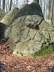
Granodiorite rocks of the Weschnitzplutons with traces of wool sack weathering. (Group of sacrificial stones on the Juhöhe)


literature
- GC Amstutz, S. Meisl, E. Nickel (ed.): Minerals and rocks in the Odenwald . (= Disclosure. Special volume 27). 1975.
- H. Kreuzer, W. Harre: K / Ar age determinations on hornblinds and biotites of the crystalline Odenwald. In: GC Amstutz u. a .: Minerals and rocks in the Odenwald. 1975, pp. 71-77.
- Erwin Nickel : Odenwald - Vorderer Odenwald between Darmstadt and Heidelberg. (= Collection of geological guides. 65). 2nd Edition. Borntraeger, Berlin 1985.
- Eckardt Stein among others: Geology of the crystalline Odenwald - its magmatic and metamorphic development. In: Annual reports and communications. Upper Rhine Geological Association. NF 83, 2001, pp. 89-111.
Maps and profiles

Geological map of the Odenwald crystalline (from: Altherr, 1999)

Geological map of the Odenwald crystalline (from: Stein, 2001)
Geological map of the Odenwald (Stein, 2001 + Weber, Geo-Naturpark)

Geological profile of the Odenwald (geo-nature park)
Map (1914) of the areas of the Weschnitzpluton and the drum granite . Further cartographic representations and aerial photographs of the region: State History Information System Hessen (LAGIS).
.jpg)
_Odw7.jpg)


References and comments
- ↑ Unit III in the structure at Eckardt Stein u. a .: Geology of the crystalline Odenwald - its magmatic and metamorphic development In: Annual reports and communications. Upper Rhine Geological Association. N.F. 83, 2001, pp. 89-111.
- ↑ Geological overview maps s. Excursion report Odenwald (pdf) .
- ↑ Geological overview maps s. Giessen University. Petrological-geological excursion Odenwald 2005 ( Memento from December 11, 2012 in the web archive archive.today )
- ^ Gustav Klemm: Geological map of Hesse. Leaf Birkenau. Hessian Geological State Institute. Recorded 1899–1928. Revised by Eigenfeld in 1963. s. Erwin Nickel: Odenwald - Vorderer Odenwald between Darmstadt and Heidelberg. (= Collection of geological guides. 65). 2nd Edition. Borntraeger, Berlin 1985, ISBN 3-443-15024-1 , map p. 64.
- ↑ Nickel, pp. 20, 101, 124.
- ↑ Nickel, p. 91.
- ↑ comparison data see Giessen University. Petrological-geological excursion 2005 Archived copy ( memento of the original from July 3, 2013 in the Internet Archive ) Info: The archive link was inserted automatically and has not yet been checked. Please check the original and archive link according to the instructions and then remove this notice.
- ↑ picture s. Giessen University. Petrological-geological excursion 2005 Archived copy ( memento of the original from July 3, 2013 in the Internet Archive ) Info: The archive link was inserted automatically and has not yet been checked. Please check the original and archive link according to the instructions and then remove this notice.
- ↑ Nickel, p. 114.
- ^ R. Altherr et al.: Plutonism in the Variscan Odenwald (Germany): from subduction to collision. In: Int. J. Earth Sci. 88, 1999, pp. 422-443.
- ↑ Nickel, pp. 12, 99.
- ↑ Calo Dietl: Structural and Petrologic Aspects of the Emplacement of Granitoid Plutons: Case Studies from the Western Margin of the Joshua Flat-Beer Creek-Pluton (White-Inyo Mountains, California) and the Flasergranitoid Zone (Odenwald, Germany) . Dissertation . Heidelberg 2000, p. 196.
- ↑ Dietl, p. 194.
- ↑ Dietl, p. 215.
- ↑ H. Kreuzer, W. Harre: K / Ar age determinations on hornblende and biotites of the crystalline Odenwald. In: GC Amstutz, S. Meisl, E. Nickel (ed.): Minerals and rocks in the Odenwald . (= Disclosure. Special volume 27). 1975, pp. 71-77.
- ↑ Dietl, p. 215.
- ↑ Todt u. a., 1995, p. Dietl, p. 216.
- ↑ Kreuzer and Harre (1975), Rittmann (1984), s. Dietl, p. 216.
- ↑ s. Nickel, map p. 15.
- ↑ Hans Graul: On the geomorphogenesis of the crystalline Odenwald. In: GC Amstutz u. a .: Minerals and rocks in the Odenwald. 1975, pp. 28-31.
- ↑ Nickel, map p. 13.
- ↑ Nickel, map p. 152.
- ↑ The names in brackets name the main locations of the unnamed waters on the map
- ^ Gustav Klemm: Geological map of Hesse. Sheet Erbach. Hessian Geological State Institute, Darmstadt. Recorded 1893–1927.
- ↑ High-lying brook gravel. s. Gustav Klemm: Explanations for the geological map of Hesse. Sheets Erbach and Michelstadt. Darmstadt 1929, pp. 2, 37.
- ↑ s. Protected and worthy of protection natural monuments in the administrative district of Karlsruhe p. 49 [PDF] Geological natural monuments in the administrative district of Karlsruhe. www.lubw.baden-wuerttemberg.de/
- ↑ s. Protected and worthy of protection natural monuments in the administrative district of Karlsruhe [PDF] Geological natural monuments in the administrative district of Karlsruhe p. 54. www.lubw.baden-wuerttemberg.de/
- ↑ Nickel, p. 114.
- ↑ s. Protected and worthy of protection natural monuments in the administrative region of Karlsruhe p. 50, picture p. 51. [PDF] Geological natural monuments in the administrative region of Karlsruhe. www.lubw.baden-wuerttemberg.de/
- ↑ a b University of Giessen. Petrological-geological excursion Odenwald 2005 ( Memento from December 11, 2012 in the web archive archive.today )
- ↑ a b "A look into the stone archives of our region" at Geo-Naturpark Bergstrasse-Odenwald ( Memento from July 31, 2012 in the web archive archive.today )
- ↑ Overview map 1: 200,000 . In: Landesgeschichtliches Informationssystem Hessen (LAGIS).