
Flaser granitoid zone

A geological complex of the Crystalline Odenwald composed of diverse gneissy and granitoid rock formations is referred to as the Flasergranitoidzone , which crystallized in granite-like grained and thinly layered structures in the Lower Carboniferous about 333 to 329 million years ago. The formations, which essentially strike in the south-west-north-east direction of the Ore Mountains, are found in a region bounded by an arc with the stations Heppenheim , Lindenfels , Reichelsheim , Groß-Bieberau , Seeheim-Jugenheim , Heppenheim. The Flasergranitoidzone represents a development stage of the Variscan orogeny, the causes and course of which are outlined under the geology of the Odenwald .
The main formations of the Flaser Granitoid Zone

A common characteristic of the diverse, closely intermingled plutonic ( gabbro , diorite , granodiorite , granite) and metamorphic stocks is the fibrous structure (parallel texture) that occurs in igneous rocks (especially granitoids, biotite diorites). Similar to the slate, the mineral structure is flat and parallel. The already simplified geological maps show a very complex rock composition. and the morphological units (surface forms) have, in addition to a more or less uniform plutonic core, zoned metamorphic frames and often several parts interrupted by mixed zones. In a very generalized way, one can differentiate between three areas from south to north, which are oriented either to SW-NE traversing mountain ridges across the zone (rooms 1 and 2) or to formations running NS (room 3):
Room 1
- Main diorite line Heppenheim / Bensheim - Lindenfels / Gadernheim between Kirschhausener- and Lautertal (slate / metapelite on the mountain flanks, diorite, only in the west aplitic granite, in the summit regions)
- The NE continuation is followed by a granite (Lindenfels) and gabbro slate gneiss area (between Lindenfels, Winterkasten, Laudenau and Reichelsheim ) as well as, to the north of it, between Fischbach and Spenztal, the Neunkirchen complex : an abundant silicic acid-containing fiber granitoid train with enclosed gneiss Diorite.

Room 2
- The mountain ranges run between Bensheim / Auerbach and Groß-Bieberau north of the Lauter and Fischbach valleys : 1. Quartz diorite from the Felsberg near Reichenbach, 2. A fibrous to gneissy Neutscher granitoid complex interspersed with many gangue rocks , 3. A fibrous or porphyry granite , Granodiorite, diorite to gabbro of the Altscheuer - back
- A gneiss line follows to the north between Hochstädten and Groß-Bieberau.
Room 3
- North of Auerbach to Seeheim, the NS-running Malschen (= Melibokus) granodiorite and the east adjoining slate gneiss zone near Balkhausen break through the SW - NE scheme. Internal structures partly oriented towards the Ore Mountains.
Individual formations are exposed in quarries , in which the granitoids for building blocks and road gravel were or are being mined: Herchenrode (north of Brandau in the Modau valley. Hornblendediorite and biotite dioritic granodiorite), Webern (east of Herchenrode on Streiterberg - slope: granite that was used during construction of the Reichstag in Berlin). Laudenau and Am Buch near Lindenfels (gabbro, gabbrodiorite, hornblenditic varieties), Hochstädten near Auerbach (flaser granitoid), Erlenbach (diorite), Am Mühlberg near Billings (diorite, flaser granodiorite in contact with granodiorite porphyrite).
Tectonic processes
By continental drift drifted in Devon - and carbon-time (about 380-320 million years ago) between a northern and a southern continent small terranes and islands towards each other. As a result of the compressions, rocks were sunk deep into the earth's crust ( subduction ) and melted at a depth of approx. 15 kilometers , and secondly - together with magma rocks - slowly pushed back up into the earth's crust, where they gradually cooled and crystallized over the course of 60 million years. The result is the Variscan Mountains, to which the Odenwald belongs, and as part of it the flaser granitoid zone running from Heppenheim / Bensheim to the Otzberg fault. It differs from the northern → Frankenstein complex , from the eastern → Böllsteiner Odenwald as well as from the adjoining → Weschnitzpluton to the south, including the → drum granite and its variations due to the complicated rock composition and the Ore Mountains orientation.
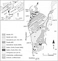
Geological map of the Odenwald (from: Altherr, 1999)

Geological map of the Odenwald (from: Stein, 2001)

Geological map of the Odenwald (Stein, 2001 + Weber, Geo-Naturpark)

Geological profile of the Odenwald (geo-nature park)

Rock cycle (geo-nature park)
.jpg)
_Odw7.jpg)


In the specialist literature, both the emergence of the mixed formations and the similarities with or the delimitation from the neighboring units of the crystalline Odenwald in connection with the tectonic processes are discussed: G. Klemm interpreted the characteristic phyllous parallel texture (PT) as the flow direction of the incoming magma the old stock, nickel, on the other hand, as a structuring when taking a seat, i.e. after the intrusion, in connection with a continuous shear (see below) movement of the overall space (syntectonics). Krohe suspects a continuous multiphase structural imprint and the reason for this is an intensive shear (stretching and lateral displacement ) and postulates the flaser granitoid zone as a large strike slip zone ( blade displacement ), i.e. H. the tectonic plates pushed past each other laterally. Stein, on the other hand, assumes a magmatic rather than a tectonic cause, v. a. for the southern part: different magma bodies ( nested diapirs ) rising in a short period of time . For the northern border area to the Frankenstein massif , he suspects an overprinting by shear movements (see below).

In this context, the question arises as to the classification of this zone in the Odenwald mountain formation. Nickel divides the area morphologically and geologically into three areas (see above). Stein combines these to form the Flasergranitoidzone and, like Altherr, delimits them due to the tectonic-metamorphic history from the two units - separated by fault zones ( strike-slip zones): Böllsteiner Odenwald and Frankenstein Complex : Radiometric , geochemical and structure-related data indicate one Suture zone between the Frankenstein complex and the Flasergranitoidzone:
- The Frankenstein gabbro intruded about 360 million years ago, 20 million years before Pluton took up space in the flaser granitoid zone .
- There are also indications of different intrusion depths: the Frankenstein gabbro is interpreted as a mantle melt product, while all plutons in the adjoining southern part of the Bergstrasse Odenwald have a crust signature.
There are different opinions regarding the southern border of the Flasergranitoidzone . Like Altherr, Willner (1991) and Krohe (1994) describe a fault zone ( strike-slip zone ) as the boundary between the Flasergranitoidzone and the Weschnitz pluton and emphasize the differences between the intrusion structures: In the southern part of the Bergstrasse Odenwald , the intrusions occur as large ones upwardly pressing plutons, whereas those of the central region mostly enter into a close and complex connection. Therefore, they divide the Bergstrasse Odenwald into two independent tectonic-metamorphic units ( unit 2 and unit 3 ).
Stein, on the other hand, summarizes the Flasergranitoidzone with Weschnitzpluton , Trommgranit and → Heidelberg granite , since he could not determine a fault zone:
- Radiometric measurements of cruisers and Wait (1975), Rittmann (1984) and dead (1995) show neither a significant time difference between the intrusions or between the high points of the metamorphoses into two units : 235 uranium / 207 lead - and 238Uran / 206Blei- dating to Zircons of metamorphic rocks that arose from sediments of the central (336–337 million years) and southern Bergstrasse Odenwald (342 million years, 332 million years) refer to thermal peaks of the regional metamorphosis. The subsequent cooling history is derived from potassium argon and 40 argon / 39 argon values from Hornblende (343-335 million years; 334 million years) and biotite (328-317 million years; 330 million years).
- No great difference was found between the geochemical signatures of the plutons of the central and southern Odenwald.
- Structures of the southernmost flaser granitoid zone do not show any extensive (only local) overprinting of the igneous structure, as would actually be expected with a large shear zone.
- In the Flasergranitoidzone also large homogeneous plutons as the coming Melibokus -Granodiorit ago. Therefore there is no general difference to the homogeneous Weschnitzpluton .
- Willner (1991) found differences in the metamorphic history between the Frankenstein complex (left-facing PT traces) and the rest of the Bergstrasse Odenwald (right).
Most of the tectonic processes in the zone are thus associated with melting of older rocks through intrusions as well as mutual infiltrations and deformations of neighboring parts, which then have similar crystalline / metamorphic structures. A special case is the Auerbach marble train , which is bordered on both sides by Hochstädter Flasergesteinen. The marble itself is believed to have originated from limestone deposited on the seabed around 390 million years ago, which was transformed into a marble during ore formation.
During Variscan and later (e.g. tertiary) tectonic processes, crevices tore open again and again in the rock mass. a. younger aplitartige Granodioritporphyre how the Alsbachit (Granodiorit quarry at Melibokus at Zwingenberg), or melting penetrated and there to dykes crystallized. Examples include a. the ore-containing ( mainly copper) quartz or barite veins near Reichenbach , which run from the Teufelsstein over the Borstein to the Hohenstein across the strike of the surrounding granites and quartz diorites.
The barite-quartz cliff of Borstein on the Teufels-Berg slope west of Reichenbach

The Teufelsstein rock continues the barite-quartz corridor to the northwest. It serves as a memorial for the dead of the Odenwald Club.

Top level of the quartzite dike on Borstein. The blocks are mainly processed into tombstones or used for gardens.

The Hohenstein cliff marks the south-eastern course of the barite-quartz corridor on the other side of the Lautertal.

On the Katzenstein near Raidelbach, the barite-quartz corridor is opened up by the opencast mine, as on Borstein.


Today's landscape of the Flasergranitoid area
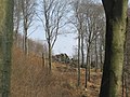
Today's varied landscape with the wavy crested peaks and the steep mountain edge to the Rhine plain developed in the tertiary age . Presumably the western part of the Flasergranitoidzone , like other mountains of the Bergstrasse Odenwald , together with the sediment layers lying on it, sank up to 3.5 km (end of the Tertiary: up to 4 km) deep into the Upper Rhine Rift than it did 45 million years ago Connection with a rift zone from the Mediterranean Sea to the North Sea, collapsed and was immediately filled up again and again by sliding down the surface and the weathered debris. Triggered by these subsidence, tremors broke the area of today's Odenwald into mountain blocks and ditches. The continually sinking Rhine Valley also laid the erosion base for the rivers and their side streams deeper and deeper, so that they increasingly cut into the rock. In addition, the warm and humid climate of this time favored weathering (more under Geology of the Odenwald ) and the rivers eroded the crystalline mountain hull.

Quartz diorite rocks and Roman stone carvings ( giant column ) in the Reichenbacher Felsenmeer .

The sea of rocks near Reichenbach was created by the different weathering processes in the Tetiary and Ice Ages. In the background the Lautertal

Altar stone group east of the Felsberg summit.
Granite rock group on the Schenkenberg in Lindenfels.


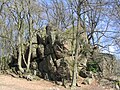
The Flasergranitoid rock group Wildfrauhaus is named after a legendary medicinal herb woman who lived in the middle of nature on the Streiterberg-Altscheuer mountain range in the Fischbachtal.

A similar Wilde Frau saga is associated with the Wildweibchenstein on the eastern slope of Germannshöhe near Laudenau.

The Falling Brook trickles over a fluffy, gneissy granitoid cliff in the castle forest near the Rodenstein ruins near Fränkisch-Crumbach.

Small flaser granitoid rock sea on the Rimdidim west slope near Steinau (northeast of Neunkirchen)


In this context, in addition to the barite quartz rock towers (see above) near Reichenbach, the large granitoid or diorite formations z. B. the Knodener head , the stone head , the Rimdidim , the thumb stone (all three northeast of Neunkirchens), the Wildweibchenstein (north of Laudenau-Freiheit) or the Spitz stone (east of Billings) modeled out: The upper parts on the ridges z. B. the Neunkircher Höhe , the Felsberg or the Krehberg torn into blocks and the subsequent chemical weathering rounded them off ( wool sack weathering ). First, they were surrounded by a 30 m deep Vergrusung later washed downpours the Grus on the slopes (talus) and into the valley where it is conveyed away the streams, and put the rocks free, partly in Auftauphasen end of the Ice Age on the permafrost slid down the valley and formed boulder seas. The Reichenbacher Felsenmeer is the best known example. In areas of the Dioritz train, e.g. B. around the Krehberg , in the areas between the Knodener Kopf and the Heiligenberg , on the slopes of the Streiterberg or the Altscheuer (between Brandau and Lichtenberg) or west of the Melibokus summit there are a number of similar, but smaller or less compact Accumulations. Most of the above formations are protected as natural monuments.
Landscape pictures: Room 1
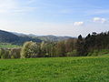
The Heppenheim-Lindenfels main diorite train (view from Unter-Hambach), on the right the Starkenburg

The hilly zone on the edge of the Odenwald to the west of the Rhine plain: From Hemsberg (left) to Eichelberg (right) near Bensheim, from Unter-Hambach.
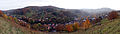
The Lautertal with its southern mountain slopes, granitoid hills on the Bergstrasse ( Hemsberg , Hubenhecke , Schlossberg with Starkenburg) in the background, the Rhine plain on the horizon ( photographed from the Borstein slope)

Northern Weschnitzpluton area with a bounding slate-diorite-gabbro-granite chain Krehberg (left) - Lindenfels (right) and Flasergranitoidberge of the Neunkircher-Höhe (center).
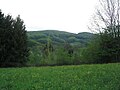
The Schlierbacher valley at Linnebach (shale, slate gneiss) and behind the diorite, gabbro- Krehberg from Gallows from


View from Eselstein over the Brombachtal to the Krehberg-Lindenfels ridge

Brombachtal, behind: Lindenfels with granite- Schenkenberg (left) and Flasergranitoid- Neunkircher-Höhe (right)

View from Böllstein (Wallbrunn) over gneiss hills (right: Schnellerts , left: Eichberg -Rücken) and the Sprenztal to the Flasergranitoid ridge Neunkircher-Höhe -Nonrod, to the left: Lindenfelser Granit-Diorit-Gabbro-Berge ( Schenkenberg , Das Buch )

Brandau peaks in front of the Neunkirchen complex (granite to gneissy granitoid with inclusions of slate gneiss and diorite). View from the Schneeberg slope south of Beedenkirchen.


Landscape pictures: rooms 2 and 3

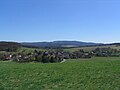
The Lautertal with the Felsberg ridge, behind the Auerbach Castle - Melibokus chain, on the horizon the Rhine plain (viewpoint: Hohenstein )

Felsberg (quartz diorite, slate gneiss) with Brandau-Beedenkirchen foreland (basites, fluffy granitoids) from "Am-Schneeberg" south of Beedenkirchen.

Reichenbach in front of the Felsberg , on the left the mining line of the barite-quartz corridor runs up the Teufels-Berg slope, behind it the granodiorite melibokus

Melibokus granodiorite (from the direction of Auerbach Castle )


The flat wave Neutscher Flasergranitoid surface in front of the Neunkircher mountain range (taken from Hundsrück northwest of Neutsch)

Neutsch (from SW) in the granite-to-gneiss granitoid complex interspersed with many dike rocks. In the background on the right: Reinheim Bay and Böllstein-Gneiss Ridge

The northern hills of the Flasergranitoidzone (left: Lichtenberg, Fischbachtal, behind Groß-Bieberau, middle right: Otzberg-Hering) from Neunkirchen that run out towards Reinheimer Bay


Geotours and rock collections in regional museums
- Minerals from the Odenwald: mansion of the Reinheim cultural center
- Information center at the Felsenmeer near Reichenbach / Lautertal (including the history and geology of the Felsenmeer , stone processing techniques used by the Romans, modern stone industry around the Felsberg )
- GEOPARK PATHS: The Lindenfels geological tour:
- Rock cliffs on the Schenkenberg slope. Section of the Li6 hiking trail.
- J (V) path from the Gagernstein forest car park south of Steinau through the middle of the granitoid-gneiss cliffs and rocky seas of the Gagernstein and Rimdidim , back on circular route 3 ( Thumb Stone , Small Rock Sea )
- Cliff hike around the Steinkopf : Loop 1 from the Gagernstein forest car park south of Steinau. At the refuge, the path branches off to the summit with the rock castle Zindenauer Schlösschen .
- Nonrod (Fischbachtal) circular route around the Spitzestein F3
- Wildfrauhaus rock cliff hike : circular route L2 from the parking lot in Lützelbach.
- Lautertal rock cliff hike : section of the Nibelungensteig from Felsberg to Krehberg .
- Krehberg rock cliff hike : Loop 4 from the Schannenbacher Eck car park .

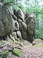
Flasergranitoid rock group on the Rimdidim slope (Gagernstein group)

Gagernstein : Flaser granitoid rock ( Rimdidim ) as a memorial stone for a writer who is close to nature

Flasergranitoid rock cliff on the Rimdidim height (499 m above sea level)

Flaser granitoid rock group Spitzestein

Summit of the Flasergranitoid rock group Spitzestein

The Zindenauer Schlösschen crowns the Steinkopf summit (451 m above sea level) north of Neunkirchen.
Climbing rocks of the Flasergranitoid Formation Zindenauer Schlösschen

Granite rock cliff with climbing rocks on the Schenkenberghang in Lindenfels


Natural monuments and climbing rocks
- Borstein barite-quartz rock tower west of Reichenbach in Lautertal
- Barite-quartzite Hohenstein east of Reichenbach in the Lautertal
- Zindenauer Schlösschen : fluffy, gneissy granitoid rock formation on the Steinkopf west of Steinau and northeast of Neunkirchen
- Granite rock on the southern Schenkenberg slope near Lindenfels
literature

- GC Amstutz, S. Meisl, E. Nickel (ed.): Minerals and rocks in the Odenwald . (= Opening up special volume 27). 1975.
- Ute Braun: Material, form and shape on the Odenwälder Felsberg. In: Amstutz u. a .: Minerals and rocks in the Odenwald. 1975, pp. 331-335.
- Calo Dietl: Structural and Petrologic Aspects of the Emplacement of Granitoid Plutons: Case Studies from the Western Margin of the Joshua Flat-Beer Creek-Pluton (White-Inyo Mountains, California) and the Flasergranitoid Zone (Odenwald, Germany) . Dissertation . Heidelberg 2000.
- Klaus-N. Hellmann: The granodiorite porphyrites of the Bergstrasse Odenwald. In: Amstutz u. a .: Minerals and rocks in the Odenwald. 1975, pp. 189-196.
- R. Hindel: Geochemical investigation of the paragneiss between Heppenheim and Lindenfels / Odenwald. In: Amstutz u. a .: Minerals and rocks in the Odenwald. 1975, pp. 135-139.
- H. Kreuzer, W. Harre: K / Ar age determinations on hornblinds and biotites of the crystalline Odenwald. In: Amstutz u. a .: Minerals and rocks in the Odenwald. 1975, pp. 71-77.
- E. Nickel, B. Zurbriggen: The development of the Neunkircher Flasergranitoide. In: Amstutz u. a .: Minerals and rocks in the Odenwald. 1975, pp. 159-174.
- Erwin Nickel : Odenwald - Vorderer Odenwald between Darmstadt and Heidelberg. (= Collection of geological guides. 65) 2nd edition. Borntraeger, Berlin 1985.
- J. v. Raumer, H. Maggetti: Basite and Paragneiss in the Heppenheim-Lindenfels area; a comparison of geological structures. In: Amstutz u. a .: Minerals and rocks in the Odenwald. 1975, pp. 39-45.
- Eckardt Stein: Investigations into the genesis of the Flasergranitoid Zone of the central Odenwald - igneous and / or tectonic structures . In: Z. geol. Knowledge 24, 1996, pp. 573-583.
- Eckardt Stein among other things: Geology of the crystalline Odenwald - its magmatic and metamorphic development In: Annual reports and messages. Upper Rhine Geological Association. NF 83, 2001, pp. 89-111.
- FK Taborsky, D. Taupitz, K. Gehlen: The Auerbacher marble. In: Amstutz u. a .: Minerals and rocks in the Odenwald. 1975, pp. 149-157.
Individual evidence
- ↑ Unit II in the structure at Altherr or Stein, Eckardt u. a .: Geology of the crystalline Odenwald - its magmatic and metamorphic development In: Annual reports and communications. Upper Rhine Geological Association, NF83, 2001, pp. 89–111.
- ↑ Geological overview maps of the University of Gießen: Petrological-geological excursion 2005 ( Memento of the original from December 11, 2012 in the web archive archive.today ) Info: The archive link has been inserted automatically and has not yet been checked. Please check the original and archive link according to the instructions and then remove this notice.
- ↑ University of Frankfurt: Geological overview maps for the Odenwald excursion report (PDF file 4.11 MB).
- ^ Nickel, Erwin: Odenwald - Vorderer Odenwald between Darmstadt and Heidelberg. (= Collection of geological guides 65) 2nd edition. Borntraeger, Berlin 1985, ISBN 3-443-15024-1 , p. 5 ff.
- ↑ Nickel, pp. 15, 128-130, 134, 135, 150, 152.
- ^ In comparison: Dietl, Calo: Structural and Petrologic Aspects of the Emplacement of Granitoid Plutons: Case Studies from the Western Margin of the Joshua Flat-Beer Creek-Pluton (White-Inyo Mountains, California) and the Flasergranitoid Zone (Odenwald , Germany) . Diss. Heidelberg 2000, p. 193.
- ^ Nickel, rooms IV-VI, pp. 111–161, maps p. 15, 128.
- ↑ Image: Heppenheimer Schieferzug. s. Giessen University. Petrological-geological excursion Odenwald . Archive link ( Memento of the original from July 3, 2013 in the Internet Archive ) Info: The archive link was inserted automatically and has not yet been checked. Please check the original and archive link according to the instructions and then remove this notice.
- ↑ Nickel, p. 146.
- ↑ Nickel, p. 14.
- ↑ Nickel, p. 157.
- ↑ Nickel, p. 115 f.
- ↑ picture s. Giessen University. Petrological-geological excursion 2005. www.uni-giessen.de Excursions Odenwald ( Memento of the original from July 6, 2013 in the Internet Archive ) Info: The archive link was inserted automatically and has not yet been checked. Please check the original and archive link according to the instructions and then remove this notice.
- ↑ Hellmann, Klaus-N .: The granodiorite porphyrites of the Bergstrasse Odenwald. In: GC Amstutz, S. Meisl, E. Nickel (ed.): Minerals and rocks in the Odenwald . (= Opening up special volume 27). 1975, pp. 189-196.
- ↑ Nickel, 1985, p. 137.
- ↑ Altherr, R. u. a .: Plutonism in the Variscan Odenwald (Germany): from subduction to collision . Int. J. Earth Sci. 88, 1999, pp. 422-443.
- ↑ Stein, Eckardt: Investigations on the genesis of the Flasergranitoid Zone of the central Odenwald - Magmatic and / or tectonic structures . Journal of Geological Sciences. 24, 1996, pp. 573-583.
- ↑ a b University of Giessen. Petrological-geological excursion Odenwald 2005 ( Memento from December 11, 2012 in the web archive archive.today )
- ↑ a b "A look into the stone archives of our region" at Geo-Naturpark Bergstrasse-Odenwald ( Memento from July 31, 2012 in the web archive archive.today )
- ↑ "The cycle of rocks: From granite to sandstone" at Geo-Naturpark Bergstrasse-Odenwald ( Memento from August 1, 2012 in the web archive archive.today )
- ↑ Dietl, p. 196.
- ↑ Nickel, p. 5.
- ↑ A. Krohe: Deformation history in the middle crust of an igneous arc - the Variscan Odenwald as a model region . Geotectonic Research 80, 1994, pp. 1-147. s. Dietl, p. 196.
- ↑ Stein, 1996.
- ↑ E. Stein: On the seating of granitoids - comparative case studies on structures and seating mechanisms from the White-Inyo Mountains, California, USA and the Bergstrasse Odenwald . Geotectonic Research, 2000, pp. 93: 330. s. Dietl, p. 194 ff.
- ↑ Stein, Eckardt u. a .: Geology of the crystalline Odenwald - its magmatic and metamorphic development In: Annual reports and communications Upper Rhine Geological Association, NF83, 2001, pp. 89–111. s. Dietl, p. 216 f.
- ↑ Altherr, R. u. a .: Plutonism in the Variscan Odenwald (Germany): from subduction to collision . Int. J. Earth Sci. 88, 1999, pp. 422-443.
- ↑ Dietl, p. 216.
- ↑ H. Kirsch, B. Kober, HJ Lippolt: Age of intrusion and rapid cooling of the Frankenstein gabbro (Odenwald, SW-Germany) evidenced by 40Ar / 39Ar and singlezircon 207Pb / 206Pb measurements . Geologische Rundschau 77, 1988, pp. 693-711. s. Dietl, p. 216.
- ↑ H. Kreuzer, W. Harre: K / Ar age determinations on hornblades and biotites of the crystalline Odenwald .- In: GC Amstutz, S. Meisl, E. Nickel (ed.): Minerals and rocks in the Odenwald . (= Opening up special volume 27). 1975, pp. 71-77. s. Dietl, p. 216.
- ↑ Kirsch u. a. 1988, pp. 693-711. s. Dietl, p. 216.
- ↑ Altherr, 1999. s. Dietl, p. 216.
- ↑ Dietl, p. 194.
- ↑ Dietl, p. 215.
- ↑ Dietl, p. 215.
- ↑ Todt u. a., 1995, p. Dietl, p. 216.
- ↑ Kreuzer and Harre (1975), Rittmann (1984), s. Dietl, p. 216.
- ↑ Altherr, 1999.
- ↑ Dietl, p. 216.
- ↑ Pictures: Marble deposits from Hochstädten. From Giessen University, Odenwald petrological-geological excursion . ( Memento from February 12, 2013 in the web archive archive.today )
- ^ S. Meisl: The gang rocks of the Melibokus area. In: GC Amstutz, S. Meisl, E. Nickel (ed.): Minerals and rocks in the Odenwald . (= Information special volume 27). 1975, pp. 175-188.
- ↑ Nickel, p. 154.
- ↑ Nickel, pp. 47, 141.
- ↑ Pictures from Aufschluss 4: Hohenstein. s. University of Frankfurt, excursion report Odenwald. P. 11 ff. (Pdf) .
- ↑ Nickel, map p. 152.
- ↑ Nickel, map p. 13.
- ↑ Excursion report Odenwald , exposure 5: Felsenmeer, p. 13 ff. (Pdf)
- ↑ pictures s. Petrological-geological excursion Odenwald : Felsenmmer near Reichenbach. ( Memento from February 12, 2013 in the web archive archive.today )
- ↑ Geo-excursion Mainzer Becken, Taunus, Odenwald: Aufschluss 16 Felsberg, Aufschluss 17 Das Felsenmeer: http://www.rainer-olzem.de/141.html
- ↑ Mineral Collection of the City of Reinheim ( Memento of the original from November 20, 2011 in the Internet Archive ) Info: The archive link was inserted automatically and has not yet been checked. Please check the original and archive link according to the instructions and then remove this notice.
- ↑ Felsenmeer Information Center
- ↑ Flayer: "Geological Tour Lindenfels" ( Memento from November 22, 2011 in the Internet Archive )
- ↑ Borstein at Felsinfo des DAV ( Memento from July 18, 2012 in the web archive archive.today )
- ^ Hohenstein - Hohenstein bei Reichenbach ( Memento from October 4, 2008 in the Internet Archive )
- ↑ "Zindenauer Schlösschen" at rock information of the DAV ( Memento from July 30, 2012 in the web archive archive.today )
- ↑ Schenkenberg at Felsinfo des DAV ( Memento from July 23, 2012 in the web archive archive.today )
- ↑ Overview map 1: 200,000 . In: Landesgeschichtliches Informationssystem Hessen (LAGIS).