
Zindenauer Schlösschen
|
Zindenauer Schlösschen
|
||
-Zindenauer_Schl%C3%B6sschen-S%C3%BCdwestseite.jpg) Natural monument "Zindenauer Schlösschen" from the southwest |
||
| location | Fischbachtal , Darmstadt-Dieburg district , Hesse | |
| surface | approx. 0.418 ha | |
| Natura 2000 ID | DE6218302 | |
| Geographical location | 49 ° 45 ' N , 8 ° 47' E | |
|
||
| Sea level | from approx. 440 m to 451 m | |
| Setup date | May 27, 1959 | |
| particularities | Natural monument before 1932 | |

The Zindenauer Schlösschen is an extensive geological natural monument in the Steinau district , Fischbachtal municipality , in the Darmstadt-Dieburg district in southern Hesse.
location
The "Zindenauer Schlösschen", sometimes also called "Zündenauer Schlösschen", is located in the natural area of the Vorderer Odenwald , Neunkircher-Höh-Odenwald. The natural monument is located southwest of Steinau and northeast of Neunkirchen . It covers the summit area of the 451 meter high Steinkopf mountain on an area of around 0.418 hectares . The entire forested mountain has been part of the Natura2000 protected area "Beech forests of the Vorderen Odenwald" (FFH area 6218-302) since 2008 .
description
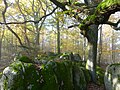
The Zindenauer Schlösschen is a mighty group of rocks reminiscent of a castle. It was already listed as a natural monument before 1932 and is today protected by ordinance of May 27, 1959 as a geological natural monument "Granite rock with an oak, called Zindenauer Schlösschen". Geologically, the rocks belong to the Flasergranitoidzone . On the ridge in the middle of the forest, some striking oaks and red beeches grow . The age of the oak named in the Protection Ordinance is estimated to be around 200 years.
tourism
A hiking path leads from a refuge on the ridge to the rock group on the Steinkopf. Decades ago it was largely unforested and offered a good view; today it is in dense high forest. The 11th BioTopTour of the Darmstadt-Dieburg district passes below the natural monument. The cliffs, which are up to seven meters high, are also used as climbing rocks.

Flaser granitoid rock castle "Zindenauer Schlösschen"
old oak tree on the top

Summit area with moss-covered rocks
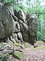
the natural monument also serves as a climbing rock

-Gipfelbereich.jpg)
-Zindenauer_Schl%C3%B6sschen.jpg)

See also
Individual evidence
- ↑ a b c Horst Bathon, Georg Wittenberger: The natural monuments of the district of Darmstadt-Dieburg with biotope tours , 2nd expanded and completely revised edition. In: Schriftenreihe Landkreis Darmstadt-Dieburg, (Ed.) District Committee of the District of Darmstadt-Dieburg - Lower Nature Conservation Authority, Darmstadt, 2016. ISBN 978-3-00-050136-4 . 243 pages. Pp. 53-55
- ↑ Otto Klausing: Geographical land survey: The natural space units on sheet 151 Darmstadt. Federal Institute for Regional Studies, Bad Godesberg 1967. → Online map (PDF; 4.3 MB)
- ↑ a b "Environmental Protection" card. BürgerGIS district of Darmstadt-Dieburg. Darmstadt-Dieburg district, accessed on August 11, 2020 .
- ↑ Management plan for the FFH area beech forests of the Vorderen Odenwald - sub-area middle. (PDF) Darmstadt Regional Council, February 15, 2016, accessed on August 12, 2020 .
- ^ Ordinance on the safeguarding of natural monuments in the Dieburg district. (pdf; 26 kB) The district committee of the Dieburg district, May 27, 1959, accessed on August 11, 2020 .
- ↑ 11th BioTopTour: To rocks and beech forests near Neunkirchen. Darmstadt-Dieburg district, 2004, accessed on August 11, 2020 .
- ↑ DAV Felsinfo: Zindenauer Schlösschen. Rock information system of the German Alpine Club, Nature and Environmental Protection Department, accessed on August 11, 2020 .