Krehberg
| Krehberg | ||
|---|---|---|
|
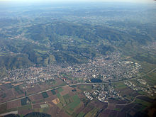
Krehberg from the northwest, seen from Auerbach Castle |
||
| height | 575.7 m above sea level NHN | |
| location | at Seidenbuch ; Bergstrasse District , Hesse ( Germany ) | |
| Mountains | Odenwald | |
| Dominance | 5 km → Neunkircher Höhe | |
| Notch height | 160 m ↓ Bundesstrasse 47 at Schelmenacker | |
| Coordinates | 49 ° 41 '3 " N , 8 ° 43' 50" E | |
| Topo map | LAGIS Hessen | |
|
|
||
| particularities | Krehberg transmitter | |
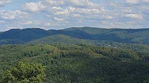
The Krehberg is a 575.7 m above sea level. NHN high mountain in the Odenwald . It is located in the Seidenbuch district of the city of Lindenfels in the Bergstrasse district of Hesse . Due to its large area, the term Krehberg massif is common. The Krehberg transmitter is located on the wooded mountain .
geography
location

The Krehberg massif is located in the Bergstrasse-Odenwald Geo-Nature Park, predominantly in the Seidenbuch district , which hugs the northeast slope at around 434 m above sea level. A small part in the northwest is in the districts of Schannenbach and Knoden . The village of Seidenbach lies at the foot of the southern slope and the village of Schannenbach at that of the northwest slope . Places in the vicinity are Glattbach , Erlenbach , Eulsbach , Knoden, Scheuerberg and Schlierbach .
The summit region of the Krehberg massif is almost a triangular pyramid with rounded shapes, the three corners of which are extended by mountain ridges . The 1.5 km long ridge that adjoins the summit region to the south-west leads to the 531.1 m high Kesselberg and the short south-east facing spur ends in the 452.7 m high cleared mountain terrace Auf dem Eck . To the northeast, an approximately 4 km long ridge on which the border runs between Lautertal in the northwest and Lindenfels in the southeast, creates the connection to the 605 m high Neunkircher Höhe .
Natural allocation
The Krehberg massif belongs to the natural spatial main unit group Odenwald, Spessart and Südrhön (No. 14) and in the main unit Vorderer Odenwald (145) to the Krehberg-Odenwald (145.5) and forms the center of this 35.45 km² subunit. This represents the link between the Neunkircher-Höh-Odenwald in the northeast and the Juhöhe -Odenwald in the south and is thus in the center of the Vorderen Odenwald. In the southeast the Weschnitz valley joins with its side valleys, overlooked by the adjoining Tromm- Odenwald, and in the northwest lies the valley of the Lauter . Beyond that rise the Melibokus and the Felsberg . In the southwest, the Krehberg-Odenwald near Heppenheim extends to Bergstrasse .
Protected areas and nature
On the western flank of the Krehberg lies the Schannenbacher Moor nature reserve ( CDDA no. 344834; designated in 1975; 16.58 hectares in size). Parts of the fauna-flora-habitat area beech forests of the front Odenwald (FFH no. 6218-302; 37.054 km² ) extend to its summit region .
On the mountain and within the protected areas, beech forest spreads , which find ideal soils and site conditions for growth. The tallest old beech trees of the former state of Hesse grow in this area .
Krehberg transmitter
The Krehberg transmitter is located on the Krehberg . It is operated by Deutsche Telekom and is a transmission system for VHF radio and radio relay . A 102 m high transmission tower made of steel framework serves as the antenna carrier.
Traffic and walking
Over the mountain saddle of the ridge leading between Lautertal and Lindenfels from Krehberg to Neunkircher Höhe - located near Kolmbach at around 415 m above sea level on Schelmenacker - federal road 47, known as Nibelungenstrasse , leads on its way from Bergstrasse to Gersprenz valley. The Nibelungensteig (“N”) leads over the mountain as a 130 km long long- distance hiking trail from Zwingenberg on the Bergstrasse through the Odenwald to Freudenberg am Main .
See also
- Krähberg , mountain in the red sandstone Odenwald in the Odenwald district
Individual evidence
- ↑ a b c Map services of the Federal Agency for Nature Conservation ( information )
- ↑ Information on Krehberg beeches in Der Name "Seidenbuch" , on seidenbuch-odw.de

