Rimdidim
| Rimdidim | ||
|---|---|---|
| height | 498.5 m above sea level NHN | |
| location | between Franconian Crumbach and Fischbachtal ; Odenwaldkreis and Darmstadt-Dieburg District , Hesse ( Germany ) | |
| Mountains | Odenwald | |
| Coordinates | 49 ° 44'18 " N , 8 ° 48'2" E | |
| Topo map | LAGIS Hessen | |
|
|
||
The Rimdidim is 498.5 m above sea level. NHN high mountain in the Odenwald . It lies on the municipal boundary of Fränkisch-Crumbach ( Odenwaldkreis ) and Fischbachtal ( Darmstadt-Dieburg district ) in Hesse .
geography
location
The Rimdidim rises in the Bergstrasse-Odenwald Nature Park . It forms a prominent elevation in the mountain range that extends from the Neunkircher Höhe ( 605 m ), the highest mountain in the Vorderen Odenwald, over the Germannshöhe ( 516.9 m ) to the northeast to the Schreckskopf ( 394.9 m ) and then gently expires. The mountain range separates the valleys of Gersprenz in the southeast and Fischbach in the northwest.
At the foot of the Rimdidim lies Steinau in the north-west and Messbach in the north-north-east , both districts of the Fischbachtal community, the highest point of which is a few meters north of the summit; the north slope drops off steeply. The actual summit plateau and the southern part of the mountain form the north-west of the forest area of the municipality of Fränkisch-Crumbach. A narrow corner of the Winterkasten district , a district of Lindenfels , extends from the southwest to near the summit. The border between the three municipalities is also the border between the Darmstadt-Dieburg district, the Odenwald district and the Bergstrasse district .
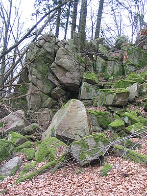
On the wooded Rimdidim are parts of the fauna-flora-habitat area beech forests of the front Odenwald (FFH No. 6218-302; 37.054 km² ). On the western slope there is a small sea of rocks of the Flasergranitoidzone . The ruins of Rodenstein Castle are located 1.2 km southeast of the summit and a few meters above the Rodenstein estate . On the transition from Rimdidim to the north-lying Hahlkopf ( 416 m ) stands the former Naturefriends House Rimdidim , a fire ruin since 2001.
Natural allocation
The Rimdidim belongs to the natural spatial main unit group Odenwald, Spessart and Südrhön (No. 14) and in the main unit Vorderer Odenwald ( Crystalline Odenwald; 145) to the subunit Neunkircher-Höh-Odenwald (145.6).
history
In a description of the Rodensteiner Mark , the mountain peak formed a border point under the name Arnstein . The current name, Rimdidim, is said to have originated after a hurricane that uprooted all trees on May 15, 1898, an ascension day, on which Arnstein.
According to stories, the naming is associated with the former Lord Mayor of Darmstadt Albrecht Ohly . On a walk he met a forester who had shown him how far one could see from the height and said in Odenwaldish : “Vun do hott mer de most beautiful view rimdidim in the Ourewald”. Soon, however, the view was blocked again by the re-grown forest.
The group of rocks on the summit of Rimdidim was a geological natural monument from 1959 to 1996 (designated on May 27, 1959, deleted on November 27, 1996).
Traffic and walking
When Rimdidim forming three branch roads, from the national road 3102 ( Lützelbach - Billings ) branches on the western edge of Steinau (western foot) to one located at the south edge of the location hikers parking leading County Road 71 off from the L 3102 (Billings- Niedernhausen ) extends the K 72 after Meßbach (north foot) and north of Reichelsheim branches off from the K 75 leading to Fränkisch-Crumbach , the K 76 running through Eberbach to the Rodenstein estate (southeast foot).
The circular hiking trails Ecumenical Pilgrimage and Gagernstein 3: Thumb stone circular route and the connecting route J lead over the mountain .
Picture gallery
Web links
- Rimdidim mountain top , on fischbachtal.de
Individual evidence
- ↑ a b c Map services of the Federal Agency for Nature Conservation ( information )
- ↑ Otto Klausing: Geographical land survey: The natural space units on sheet 151 Darmstadt. Federal Institute for Regional Studies, Bad Godesberg 1967. → Online map (PDF; 4.3 MB)
- ↑ Horst Bathon, Georg Wittenberger: The natural monuments of the Darmstadt-Dieburg district with biotope tours , 2nd expanded and completely revised edition. In: Schriftenreihe Landkreis Darmstadt-Dieburg, (Ed.) District Committee of the District of Darmstadt-Dieburg - Lower Nature Conservation Authority, Darmstadt, 2016. ISBN 978-3-00-050136-4 . 243 pages. P.56


