
Böllsteiner Odenwald

As Böllsteiner Odenwald the northeastern part of the will Crystalline Odenwald between the Gersprenz lowlands in the west and Sandstone Odenwald referred to the east, the village situated therein Böllstein gave the name. This geological formation and at the same time a natural subunit consists of pre- or early Variscan granitoid gneisses shaped in several tectonic phases and thus represents the oldest development stage of mountain formation documented in the Odenwald, the causes and course of which are outlined under the geology of the Odenwald .
Natural space
With an area of 44.99 km², the Böllsteiner Odenwald forms the natural spatial subunit 145.9 of the main unit 145 Vorderer Odenwald within the main unit group 14 Odenwald, Spessart and Südrhön . Over a length of about 11 kilometers, it occupies the ridge with the watershed between the valley systems of the Gersprenz in the west and the Mümling in the east, reaching a width of about 4 kilometers. The ridge begins in the south, following the towering Morsberg (517 m) on the Spreng and ends in the north, already in the Reinheim hill country , with the striking volcanic cone of the Otzberg (367 m). The highest elevations in the ridge line of the Böllsteiner Odenwald itself are from south to north the Heidelberg (443 m) as the highest elevation, then the Böllsteiner Höhe (416 m), followed by an unnamed hill with a refuge (404 m) and Ballerts (375 m) m), Tannenkopf (388 m), Hermesberg (377 m), Koppelwald (375 m) and finally Klingelskopf (361 m). A historic old street leads over this ridge line , which is called Alte Erbacher Straße in the southern part and is known as Hohe Straße in the northern extension . A large number of small flowing waters strive from the Böllsteiner Odenwald to the valley, whereby the streams facing east to Mümling have a longer flow path than those heading towards the Gersprenz in the west, but they have a steeper gradient.

In the Böllsteiner Odenwald there are 14 villages and hamlets enumerated from south to north: Nieder-Kainsbach , Hembach , Böllstein, Stierbach , Affhöllerbach , Kilsbach , Wallbach , Birkert , Mittel-Kinzig , Ober-Kinzig , Gumpersberg , Hummetroth , Höllerbach and Hassenroth .
While in the western part the settlements are mainly to be found in the valley areas near the Gersprenz, the villages of the eastern roofing and their cleared areas are often found up to the heights of the ridge line. The Böllsteiner Odenwald is on the whole an undemanding and low-yield arable farming area, in which agriculture is increasingly being practiced only as a sideline . Instead, many residents have found work in the nearby Rhine-Main area , benefiting from the good transport links . In return, this rural region has developed into a local recreation area and in this way finds an economic balance for the previously important quarry industry .
Rocks of the Böllsteiner Odenwald
The eastern crystalline Odenwald ends morphologically in the Groß-Umstädter basement ( granite , Permian quartz porphyries ), which forms the eastern edge (= Otzberg gap) of the Reinheimer Bucht and dips to the east under the red sandstone step. This granite and gneiss -Gesteine be combined with those of Vorspessarts interpreted.
To the south, separated by the northern foothills of the slate zone, is the Böllsteiner Massif: the main rocks , granodiorite and granite gneisses, of this fairly uniform, dome-shaped formation between the Otzberg gap, which runs roughly parallel to the Spenz valley, and the red sandstone edge in the east ( Hummetroth to Spreng , then arching to the west to four storeys) are surrounded by a surrounding slate shell (about 50% mica , 45% quartz, 5% potassium feldspar ).
The southern end of the gneiss area is the Erzbacher Scholle (granitoid, slate gneiss north of Rohrbach as a border).
The Böllstein granodioritic to granitic gneisses can be used depending on the context, e.g. B. when mixed with other gneisses, with gnarled gabbro lenses or adjacent slates, fibrous structures or restless structures. The average mineralogical composition: for granodiorite gneisses (and granite gneisses): 35 - 45% (15 - 35%) plagioclase , 20 - 35% (30 - 40%) quartz, 5 - 20% (30 - 40%) potassium feldspar and 5 - 10% (1 - 5%) biotite .
Such formations are still open in cliffs and quarries, in which granitoid gneisses, slate or gabbros for building stones and road gravel were or are being mined: z. B. on Wannberg east of Böllstein (gneiss, granitoid with 280-300 million years old fluvial sediments from the Permian), on Weichberg east of Affhöllerbach (granite gneiss), on Lattersberg near Ober-Kainsbach (gabbro, slate gneiss), east of Vierstöck (gabbro ) south and east of Groß-Umstadt (quartz porphyry of Knosberg).
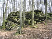
Gneiss cliff (natural monument) of the Böllsteiner Höhe falling to the east : alternately narrow-lined and flabby-eyed.

This mighty gneiss rock group serves as a memorial stone for the dead of the world wars.

Folded migmatic slate gneiss layers (gneiss cliff on the Böllsteiner Höhe )
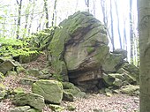
Gneiss - rocks in the shape of a turtle's head (Böllstein- Wallbrunn )

Rocks ( Wallbrunn ) with weathering forms.
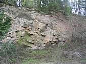
280 to 300 million years ago, the gneiss mountains were largely eroded. In the Permian land surface (on the Wannberg east of the Böllsteiner Höhe ) a river cut a channel (from top left obliquely to the right) and filled it with rubble and sand.


The separation from the Bergstrasse Odenwald is taken over by the gneiss of the intermediate zone with an average mineralogical composition of 30 - 50% plagioclase, 15 - 25% quartz, 10 - 30% potassium feldspar, 5 - 10 in the further course of the Otzberg fissure, from Beerfurth to the south to Aschbach % Biotite, 0 - 10% hornblende . As a narrow strip they border on Weschnitzpluton and Trommgranit in the west and dip under the red sandstone step in the east.
Tectonic processes

By continental drift drifted in Devon - and carbon -time (before about 380 - 320 million years ago) in a sea area between a large north and a southern continent crustal blocks ( Terrane ) and islands towards each other. As a result of the compressions, rocks were sunk deep into the earth's crust ( subduction ) and melted at a depth of approx. 15-18 km , and secondly - together with magma rocks - slowly pushed back up into the earth's crust, where they gradually cooled over the course of 60 million years and crystallized. This is how the Variscan Mountains , to which the Odenwald belongs, and as part of it, with its own development, the Böllsteiner Odenwald came into being.
In the specialist literature, both the formation of the rock formations of the Böllsteiner Odenwald and the similarities with or the delimitation from the neighboring units of the crystalline Odenwald and the Spessart in connection with the tectonic processes are discussed:
On the basis of radiometric strontium and potassium-argon analyzes , Lippolt interprets both Old Paleozoic ( Silurian / Devonian) and Carboniferous relationships for granodioritic biotite gneisses of the central part of the Böllsteiner Odenwald . Granite gneiss samples showed an age of 360 ± 56 million years (on the Devonian / Carboniferous border). For both types of gneiss together an average of 413 ± 26 million years. Hornblende gneisses in the crystalline window in Breuberg (Neustadt) were dated to a rubidium - strontium age of 369 ± 14 million years and confirmed the age differences to the Bergstrasse Odenwald. The intrusion of the predecessors of the rocks examined could possibly have occurred during the Silurian, at the latest during the early Devonian. By determining the ages of mica, hornblende and apatite for the ages of potassium , argon and rubidium-strontium , middle carbonic values were determined and assigned to a cooling phase after metamorphosis and mylonitization .
For cruisers etc. a. the potassium-argon dating at Hornblende (363 million years for the Weichberg gneiss) indicate the formation of these rocks in connection with the end of an early phase of the Variscan deformation, the biotite values (309, 312 million years) are indications on a later decay of the tectonic processes than in the Bergstrasse Odenwald.

In connection with these data with the theory of plate tectonics , the formation of the Central German Crystalline Zone (MDKZ) is interpreted as an igneous arc, whereby Bergsträßer and Böllsteiner Odenwald have a different history. They came from two different terran or islands. The gneisses were already formed before the collision of the crust blocks on the Silurian-Lower Devonian border in a subduction zone by intrusions of igneous (predominantly granitic) rock melts into sedimentary rocks. This resulted in a recrystallization (metamorphosis) or mylonitization and metamorphic slate and gneiss, with which the complexes of the Bergstrasse Odenwald were pushed together in the course of the Variscan processes 360-310 million years ago: with the result of renewed recrystallization. The Otzberg Fissure is considered to be the line where the plutons met.
The quartz porphyries of the northeastern Odenwald are arranged in a Nazi line on the eastern edge of the Reinheimer Bucht between Brensbach and Groß-Umstadt along the Otzberg gap, as an old fault zone. These igneous rocks were formed in the time of the Upper Rotliegend about 260 million years ago, when great tremors in the earth's crust shook the Odenwald and volcanoes penetrated from the earth at old fault zones, tuffs and glowing clouds hurled out of their craters and lava fell onto a gently rolling gneiss. The surface of the earth that was left after the weathering of the Variscan mountains was poured.
The area around Hummetroth to the north bordering the Böllsteiner Gneiss and the formations to the east are still geologically shaped by the sedimentation period following the mountain formation: About 260 million years ago - the granite-gneiss mountain range has now largely been eroded to the base - flooded In the geological age of the Younger Permian the so-called Zechstein Sea the Odenwald and covered it with deposits that are important for mining: dolomites , into which iron and manganese-containing quartz and barite solutions later penetrated. Relics from the Zechstein Age is the undulating plateau between Höllerbach and Hummetroth, which u. a. consists of yellow-brown and partly iron and manganese-containing, almost black dolomite soil (former limestone quarry near Hummetroth). In the 19th century, in the Hummetroth-Kinzig area, on the WNE slopes of the Morsberg (Spreng, Bockenrod) and Rohrbach-Erzbach, on the Kahleberg near Weschnitz and NE or S von Wald-Michelbach at the edge of the steps, tunnels were drifted under the lower layer of red sandstone in the ore-bearing Zechstein, in order to mine iron and manganese (see below: geopaths and museums).
The eastern border of the Böllsteiner Odenwald is formed by the red sandstone deposits (lower B. and the main stage to the east of the middle B.) from the Mesozoic ( Mesozoic Era) between 250 and 65 million years. At that time up to 600 m thick red sandstone, shell limestone - Keuper - and Jura layers were deposited, most of which are no longer preserved in the Odenwald, with the exception of the red sandstones z. B. the mountain ranges bordering the Böllsteiner Odenwald to the east (more under Geology of the Odenwald ).
During Variscan and later (e.g. tertiary) tectonic processes, crevices repeatedly tore open in the rock masses of the basement. a. Barite or iron - manganese - copper melts penetrated, which crystallized into gangue rocks or ore veins, such as Hummetroths to the west, Herings (Zipfen) to the east and Groß-Umstadt to the east (former manganese mining in an ore-bearing barite vein). In the area of Ober-Kainsbach , Unter-Easter and Upper-Easter- Weschnitz, barite, but also pure quartz iron luster veins in the basement were opened up by mining.
Geological maps

Geological map of the Odenwald (from: Altherr, 1999)

Geological map of the Odenwald (from: Stein, 2001)
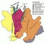
Geological map of the Odenwald (Stein, 2001 + Weber, Geo-Naturpark)

Geological profile of the Odenwald (geo-nature park)

Rock cycle (geo-nature park)
.jpg)
_Odw7.jpg)


Today's landscape
Today's landscape in the northeastern Odenwald developed in the Tertiary , d. H. It is shaped on the one hand by the weathering processes and on the other hand by the rocks that erupted during volcanic eruptions, e.g. B. the quartz porphyries and basalts (Zipfen, Otzberg) at the edge of the Reinheim Bay for which a potassium-argon age of 44 (Zipfen) to 22 (Otzberg) million years was determined.
The main reason for the current morphology is the lowering of the Upper Rhine Rift . 45 million years ago tremors broke the area of today's Odenwald into mountain blocks and trenches. These tectonic processes were accompanied by an increase in volcanic activity. The continually sinking Rhine valley also deepened the erosion base for the rivers and streams, so that they increasingly cut into the rock.
In addition, a warm, humid subtropical climate favored weathering. Not only were the mighty layers of red sandstone (red sandstone and basement inclusions in the Otzberg nepheline basalt) that had deposited on the granite base of the mountains in the Mesozoic era, crushed and eroded by the rivers , but also the crystalline mountain marsh that was exposed again in the area of the Böllstein Odenwald. This also created the gneiss cliffs z. B. on the slope of the Burgberg (404 m) west of Vierstöck, around the Böllsteiner Höhe (416 m), on the Ober-Kainsbacher slope of the Hohen Stein (389 m) or on the north slope of the Schnellerts : the upper parts on the ridge torn into blocks and the subsequent chemical weathering crumbled them from the edges so that they were surrounded by weathered gravel. These erosions continued in the subsequent Ice Age: downpours exposed the rocks and washed the gravel, sand and loam onto the slopes (debris cover) and into the valleys, where they carried the streams to the subsidence areas such as the Reinheim Bay in the east deposited there.
From Böllstein (Wallbrunn) to the northwest you can see the basalt Roßberg over the gneiss hills of the Schnellert and the Reinheimer Bucht . Left in the background the mountains of Flasergranitoidzone (are on the western Gesprenzseite Steinkaute ) to see.
View from Böllstein ( Wallbrunn ) to the west: over gneiss hills (right: Schnellerts , left: Eichberg -Rücken) and the Sprenztal to the Flasergranitoid ridge of Neunkircher-Höhe - Nonrod

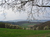
The Gersprenztal (Laudenau on the left, Reichenberg in the middle) and behind it the ridge of the Böllsteiner Odenwald and on the right the red sandstone step of the Morsberg . On the horizon: the areas of the red sandstone Odenwald. In the foreground: winter box between the hills of the Flasergranitoidzone


Geotours and rock collections in regional museums
- Minerals from the Odenwald: mansion of the Reinheim cultural center
- Mining department of the Reichelsheim Museum
- Geo-hike Ancient mining and barite of Upper Easter and the Alme
- Geopark educational trail ore and difficult spade
- Geopark educational trail for the Reichelsheim mining landscape

literature

- GC Amstutz, S. Meisl, E. Nickel (ed.): Minerals and rocks in the Odenwald . (= The Exposure. Special Volume 27). 1975, DNB 770582079 .
- Hans Joachim Lippolt: Evidence of the ancient Paleozoic primary age (Rb-Sr) and carbonic cooling age (K-Ar) of the muscovite-biotite gneisses of the Spessart and the biotite gneisses of the Böllsteiner Odenwald. In: Geologische Rundschau. 1986, Volume 75, Number 3, pp. 569-583.
- Erwin Nickel : Odenwald - Vorderer Odenwald between Darmstadt and Heidelberg. (= Collection of geological guides. 65). 2nd Edition. Borntraeger, Berlin 1985, ISBN 3-443-15045-4 .
- Eckardt Stein among others: Geology of the crystalline Odenwald - its magmatic and metamorphic development. In: Annual reports and communications. Upper Rhine Geological Association. NF83, 2001, pp. 89-111.
References and comments
- ↑ Unit IV in the structure at Altherr or Eckardt Stein u. a .: Geology of the crystalline Odenwald - its magmatic and metamorphic development. In: Annual reports and communications. Upper Rhine Geological Association. NF83, 2001, pp. 89-111.
- ↑ a b c d Universities of Tübingen and Gießen, AKN - Working Group Climate and Natural Hazards: Petrological-geological excursion Odenwald 2005, with geological overview maps ( Memento from December 11, 2012 in the web archive archive.today )
- ↑ Geological overview maps s. Excursion report Odenwald of the University of Frankfurt (PDF).
- ↑ Altenberger, Besch 1993, p. Carlo Dietl: Structural and Petrologic Aspects of the Emplacement of Granitoid Plutons: Case Studies from the Western Margin of the Joshua Flat-Beer Creek-Pluton (White-Inyo Mountains, California) and the Flasergranitoid Zone (Odenwald, Germany) . Dissertation . Heidelberg 2000, p. 191.
- ^ Emil Meynen , Josef Schmithüsen : Handbook of the natural spatial structure of Germany . Federal Institute for Regional Studies, Remagen / Bad Godesberg 1953–1962 (9 deliveries in 8 books, updated map 1: 1,000,000 with main units 1960).
- ↑ Various authors: Geographische Landesaufnahme: The natural spatial units in single sheets 1: 200,000 . Federal Institute for Regional Studies, Bad Godesberg 1952–1994. → Online maps of the natural space units ; here: sheet 151 Darmstadt (Otto Klausing 1967; 61 p.)
- ↑ Map and legend of the natural areas of Hesse (online copy of Die Naturraum Hessens , Otto Klausing 1988) in the Hessen Environmental Atlas of the Hessian State Office for Environment and Geology
- ^ Erwin Nickel: Odenwald - Vorderer Odenwald between Darmstadt and Heidelberg. (= Collection of geological guides. 65). 2nd edition Borntraeger, Berlin 1985, p. 175.
- ↑ Nickel, p. 36.
- ↑ The mineralogist paul ramdohr has shortly after the First World War at Wilhelm Bruhns at the mountain academy Clausthal over gabbros in the area Böllstein / Brombachtal habilitation .
- ↑ Nickel, 1985, p. 37.
- ↑ s. Image, 3rd exposure of the Wannberg quarry in the Odenwald excursion report of the University of Frankfurt (PDF).
- ↑ Geo-excursion Mainzer Becken, Taunus, Odenwald: Exposure 19: Sedimentation channel on the Wannberg:
- ↑ Geo-excursion Mainz Basin, Taunus, Odenwald: Exposure 18: Quarry on the Weichberg north of Böllstein.
- ↑ Universities of Tübingen and Gießen, AKN - Working Group Climate and Natural Hazards: Petrological-Geological Excursion Odenwald 2005, 2.3 Quarry of the company Röhrig am Weichberg with photos of the outcrop ( Memento from December 25, 2013 in the web archive archive.today )
- ↑ Nickel, 1985, p. 36.
- ↑ R. Altherr u. a .: Plutonism in the Variscan Odenwald (Germany): from subduction to collision . In: Int. J. Earth Sci. 88, 1999, pp. 422-443.
- ^ Nickel: Geological position and petrogenesis of the crystalline Odenwald. In: GC Amstutz, S. Meisl, E. Nickel (ed.): Minerals and rocks in the Odenwald . (= The Exposure. Special Volume 27). 1975, pp. 2-25.
- ↑ M. Okrusch, J. v. Raumer, S. Matthes, W. Schubert: Mineralfaziel and position of the metamorphic rocks in the crystalline Odenwald. In: Amstutz u. a., pp. 110-134, v. a, pp. 114, 127.
- ↑ Nickel, 1985, p. 175 ff.
- ↑ Dietl, p. 193 ff.
- ^ HJ Lippolt, I. Baranyi, I. Raczek: Rb-Sr chronology of orthogneises in the eastern Odenwald and southern Spessart / Germany . ECOG IV (congr. 1976, abstr. 65.), s. Nickl, p. 176.
- ↑ Hans Joachim Lippolt: Proof of the ancient Paleozoic primary age (Rb-Sr) and carbonic cooling age (K-Ar) of the muscovite-biotite gneiss of the Spessart and the biotite gneiss of the Böllsteiner Odenwald . In: Geologische Rundschau. 1986, Volume 75, Number 3, pp. 569-583.
- ↑ H. Kreuzer, W. Harre: K / Ar age determinations on hornblende and biotites of the crystalline Odenwald . In: Amstutz, pp. 71-77.
- ↑ Henes-Klaiber 1992, Kreher 1994. s. Dietl p. 191.
- ↑ AK Schmitt u. a .: The onset and origin of differentiated Rhine Graben volcanism based on U-Pb ages and oxygen isotopic composition of zircon . In: Europ. J. Mineral. 19, 2007, pp. 849-857.
- ↑ Michael Fettel: Mining history of the Odenwald. In: Amstutz, pp. 267–280.
- ↑ G. Frenzel: The Nepheling Stone Sparagenesis of the Katzenbuckels in the Odenwald . (= The Exposure. Special Volume 27). Heidelberg 1975, pp. 213-228.
- ↑ Nickel, 1985, p. 44 ff.
- ↑ a b "A look into the stone archives of our region" at Geo-Naturpark Bergstrasse-Odenwald ( Memento from July 31, 2012 in the web archive archive.today )
- ↑ "The cycle of rocks: From granite to sandstone" at Geo-Naturpark Bergstrasse-Odenwald ( Memento from August 1, 2012 in the web archive archive.today )
- ↑ "A look into the stone archives of our region" at Geo-Naturpark Bergstrasse-Odenwald ( Memento from July 31, 2012 in the web archive archive.today )
- ↑ z. B. Forstberg nepheline basanite on the western border of the Spenz trench, Otztberg nepheline basalt on the E-flank, s. Nickel, p. 151.
- ↑ Hans J. Lippolt, István Baranyi, Wolfgang Todt: The potassium-argon ages of the post-Permian volcanic rocks of the north-eastern Upper Rhine Rift. In: Amstutz, pp. 205-212.
- ↑ map s. Lippolt, p. 207.
- ↑ AK Schmitt u. a .: The onset and origin of differentiated Rhine Graben volcanism based on U-Pb ages and oxygen isotopic composition of zircon . In: Europ. J. Mineral. 19, 2007, pp. 849-857.
- ↑ Universities of Tübingen and Gießen, AKN - Working Group Climate and Natural Hazards: Petrological-Geological Excursion Odenwald 2005, 2.4 Böllstein, war memorial with photo of the cliffs ( Memento from February 12, 2013 in the web archive archive.today )
- ↑ Nickel, 1985, p. 13.
- ^ Mineral collection of the city of Reinheim ( Memento from November 20, 2011 in the Internet Archive )
- ↑ A walk through the newly designed mining department of the regional museum in Reichelsheim
- ^ Leaflet: Mining around Reichelsheim
- ↑ Geopark educational trail building block, ore and heavy spar (Odenwald)
- ↑ Flyer Geopark educational trail mining landscape Reichelsheim "Vier-Stöck - Rohrbach" ( Memento from November 22, 2011 in the Internet Archive )
- ↑ Overview map 1: 200,000 . In: Landesgeschichtliches Informationssystem Hessen (LAGIS).