
Drum granite

The drum granite forms the eponymous ridge between Reichelsheim and Weinheim and, together with the Heidelberg granite in the southern part of the Crystalline Odenwald, marks the end of the eastern gneiss zone and the red sandstone steps lying on it. It consists essentially of biotite granites that were found in the Lower Carboniferous about 320 Crystallized millions of years ago, and thus represents one of the last phases of intrusion in the Variscan mountainous formation, the causes and course of which are outlined under the geology of the Odenwald .
The biotite granite
The granite of the Tromm with its characteristic large reddish speckles (= porphyry-like granite pG) is composed primarily of the light-colored mixture parts quartz , potassium feldspar and soda lime feldspar ( plagioclase ). The average mineralogical composition is around 35–40% plagioclase, 30–35% quartz, 25–35% potassium feldspar and 5–10% biotite (dark mica) and is similar to that of → Heidelberg granite , which has around 10% less quartz and a little contains more potassium feldspar.

Not only on the western Trommhang between Schimbach and Rohrbach (Mörlenbach) , but also on the ridge from Scharbach (Grasellenbach) to Ober-Abtsteinach , the biotite granite was rubbed through by younger aplitic granite intrusions (G2). These replenishments have hardly any biotite, less plagioclase and more potassium feldspar than Tromm pG. Such formations are still open in quarries in which the biotite granite for building blocks and road gravel was mined: especially on both slopes of the Tromm z. B. at Borstein near Zotzenbach , at Gärtnerskopf Ober-Mengelbach or near Scharbach.
Tectonic processes
By continental drift drifted in Devon - and carbon-time (about 380-320 million years ago) in a sea area between a large north and a southern continent crustal blocks ( Terrane ) and islands towards each other. As a result of the compressions, rocks were sunk deep into the earth's crust ( subduction ) and melted at a depth of approx. 15 kilometers , and secondly - together with magma rocks - slowly pushed back up into the earth's crust, where they gradually cooled and crystallized over the course of 60 million years. This is how the Variscan Mountains came into being , to which the Odenwald belongs.
The drum granite intruded in the late phase of mountain formation. Biotite analysis has dated the end of Variskan influences on a large scale to 322 million years, the cooling of the Bergstrasse Odenwald is assumed to be 329 million years. The data for the southern Tromm and Heidelberg granites and the aplite granites (318 and 320 million years ago) indicate regional and local more recent intrusions. As a result of these processes, an area with mixed zones to the neighboring formations results, compared to the Weschnitz pluton (see below), in terms of rock composition and formation:

- Towards the west, north and east (see map), the drum granite sets itself apart as a relatively uniform biotite granite mass compared to older formations, but with interlocking and flowing transitions that are created by contact metamorphosis .
- At its northern tip (in the Kohlwald area north of the Weschnitz breakthrough) the drum granite meets the Weschnitz pluton and an intermediate gneiss zone .
- From this intersection via Hammelbach to the south of Scharbach, the gneiss intermediate zone on the eastern slope of the Trommrücken forms the eastern border of the biotite granite. This narrow strip, which can be detected as far as Aschbach, marks an old fault zone , the Otzberg gorge running along the NNE , which continues from the Otzberg - via Wald-Michelbach - south to the Upper Rhine Rift - Heidelberg - Karlsruhe border and forms the western edge of the Böllsteiner gneiss , which is mostly hidden under the red sandstone ceiling in the Überwald (also under the geology of the Odenwald ). On this line, due to the continental drift, the western Bergstrasse Odenwald pushed against the 50 million years older eastern → Böllsteiner-Gneis-Odenwald . According to the theory of continental drift , during this last phase of the collision of two dwarf continents or islands, the drum granite intruded and welded the Bergstäßer to the Böllstein Odenwald .
- South of Scharbach, the drum granite borders on the red sandstone step (see also → Buntsandstein-Odenwald ), which runs from Affolterbach , Aschbach to Heddesbach in the fault zone along the Ulfenbach valley, then swings out in an arch southwest to Heidelberg and thereby covers the granite. (Also under Geology of the Odenwald )
- In the north and west, the older → Weschnitzpluton , crystallized about 333 to 329 million years ago, joins. The border runs, with relatively clear separation, in a south-westerly direction on the slopes of the Trommrücken, east of the Weschnitz Valley communities to Weiher .
- The demarcation between Weiher and Weinheim becomes difficult: the tectonics resulted in drum granite clods, etc. a. near Zotzenbach and Mörlenbach , smashed ( mylonitized ). Similar granite stocks that have been ground and re-solidified into rocks can be found on the eastern slope of the ridge near Weschnitz , Hammelbach and Scharbach (see above Otzbergspalte).
- Around Weiher-Vöckelsbach-Ober-Mengelbach, granitic rocks mix with converted old stocks from the time before the Variscan mountain formation , e.g. B. Biotite-plagioclase-gneiss-clods - formerly known as amphibolite . In the old quarry Am Gärtnerskopf (Ober-Mengelbach) such intrusions of the drum granite in the gneiss are exposed (see pictures below)
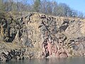
At the Gärtnerskopf near Ober-Mengelbach around 320 million years ago hornblende-biotite-plagioclase-gneiss (amphibolite) mixed with reddish drum granite .

The mixed rocks of drum granite and dark amphibolite become streak-like, lighter, coarse-grained and granite-like.

Granite potassium feldspar blasts infiltrated the gneiss basement.


- To the south, partly separated by a mixed zone, the so-called clod agglomerate , between Weinheim and Wald-Michelbach, the Heidelberg granite , which is related to the drum granite and of about the same age, adjoins it. The clod agglomerate is a group of rocks that have been metamorphosed in the course of mountain formation and dissolved by granite intrusions.

View from the Trommgranit plateau onto the clod agglomerate (granodiorite, granite, diorite, gneiss in rubble) near Ober-Abtsteinach: on the left the Waldskopf , on the right the Götzenstein

Unter-Abtsteinach in front of the middle red sandstone step of the Hardberg and the Stiefelhöhe

Waldskopf between Löhrbach and Abtsteinach in the clod agglomerate : pG summit, the slopes of diorite and gneiss

Hill of diorite-granodiorite-granite mixing zone between the Kallstädter- and Gorxheimer Valley (from forest head off), in the background: Rhine Valley and the Palatinate mountains

Kallstädter Tal and Kisselbusch in the mixed area north of Löhrbach. The Juhöhe-Hirschkopf range of hills bordering the Weschnitz valley on the horizon


In the specialist literature, both the origin of the various formations of the crystalline Odenwald and the delimitation from the neighboring units in connection with the tectonic processes are discussed. There are different opinions regarding the delimitation of the southern granite and granodiorite complexes from the central → Flasergranitoidzone . Like Altherr, Willner (1991) and Krohe (1994) describe a fault zone (strike-slip zone) as the boundary between the Flasergranitoidzone and the Weschnitzpluton and emphasize the differences between the intrusion structures: In the southern part of the Bergstrasse Odenwald , the intrusions rise as large ones urgent plutons, whereas they mostly form a close and complex connection to the central region. Therefore, they divide the Bergstrasse Odenwald into two independent tectonic-metamorphic units ( unit 2 and unit 3 ). Stein, on the other hand, summarizes the Flasergranitoidzone with Weschnitzpluton , Trommgranit and Heidelberg granite , since he could not determine a fault zone.
V. a. Radiometric measurements by Kreuzer and Harre, Rittmann (1984) and Todt (1995). They show neither a significant time difference between the intrusions nor between the peaks of the metamorphoses in both units : 235 uranium / 207 lead and 238 uranium / 206 lead dating on zirconia of metamorphic rocks that arose from sediments of the central (336-337 million). Years) and the southern Bergstrasse Odenwald (342 million years, 332 million years) refer to thermal peaks of the regional metamorphosis. The subsequent cooling history is derived from potassium argon and 40 argon / 39 argon values from Hornblende (343-335 million years; 334 million years) and biotite (328-317 million years; 330 million years). Further evidence is listed under Flasergranitoidzone .
Today's landscape
Between the neighboring geological units, the core area of the drum granite is also morphologically visible as a unit between the Weschnitztal and Ulfenbachtal. Today's landscape developed in the tertiary age . Triggered by the lowering of the Upper Rhine Rift 45 million years ago, tremors broke the area of today's Odenwald into mountain blocks and ditches. The continually sinking Rhine valley also laid the erosion base for the Weschnitz and Neckar and their side streams such as the Ulfenbach ever deeper, so that the rivers increasingly cut into the rock. In addition, the warm, humid climate of this time favored weathering. So not only the mighty red sandstone and shell limestone layers, which had deposited on the granite base of the mountains in the Mesozoic Era (more under Geology of the Odenwald ), were crushed and eroded by the rivers , but also the again exposed crystalline mountain hull.

Northern Weschnitzpluton hill (towards Fürth) with north-east delimiting drum granite chain (Großes Köpfchen - Wagenberg)

South of the Weschnitz breakthrough , the Brombach cut into the intermediate zone -Trommgranit mountain slope between Eselstein (left) and Erzberg (right).

The Tromm mountain range from Groß-Breitenbach (Fohlenweide): on the left the Tromm granite area in the Schimmelberg - Kreidacher Höhe area , rubbed through by G2 , in the middle in the background behind the Weiherer valley the Buntsanstein step near Siedelsbrunn (Hardberg) , on the right the plaice agglomerate in the area Götzenstein and Kisselbusch

Weschnitzpluton hill (towards Weinheim) before Trommgranit granodiorite chain (Götzenstein) to rhyolite (porphyry) -Wachenberg.

View from the Hirschkopf into the mixed zone between Tromm- and Heidelberger-Granite : Kisselbusch , Götzenstein , Buntsandsteinstufe ( Hardberg - Stiefelhöhe ), Buchklingen between Waldskopf and Geiersberg , mountains south of the Gorxheimer valley (from left)


The steep slope of the Trommrücken to the Weschnitz Valley, which is about 370 m lower, is explained by the better weathering properties of the Weschnitz pluton and by fault lines along the valley, where clods of the basement and the overburden sank in the Tertiary - like at the edge of the Rhine rift. This is indicated by red sand stones drilled under the weathering gravel near Fürth.
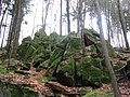
In this context, the granite rock castles of the Lindenstein and Wildleuthäusl on the Tromm and the Götzenstein (natural monuments of the Bergstrasse district, see below) were created: The upper parts on the ridge were torn into blocks and the subsequent chemical weathering rounded them off ( wool sack weathering ). First, they were surrounded by a 30 m deep Vergrusung later washed downpours the Grus on the slopes (talus) and into the valley where it is conveyed away the streams, and laid granite rock free, in Auftauphasen end of the Ice Age on the permafrost to slid down the steep slopes to the Weschnitz valley and formed block seas, z. B. below the Fahrenbacher head and the Salzlackenbuckels .

On the Trommhang , which slopes steeply towards the Weschnitz Valley , you will find a large number of mighty rock castles and block heaps, e.g. B. the Lindenstein - drum granite formation.
Similar to other Wildleuthäusl ™ stones are also connected to the Tromm with the forecast, among the granite blocks lie one of the wild men guarded treasure hidden.

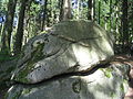
Another of the many rock groups of the Tromm (on the mountain ridge between Salzlackenbuckel and Wagenberg ) is noticeable through eroded crevice fillings.

The Teufelsstein is located in the clod agglomerate west of the Waldskopf . According to a legend, the quartz column filling is the imprint of the chain with which the devil was once tied to the rock.
When the chain was torn, the gap that separates the tape should have arisen.

Granodiorite rock formation Götzenstein northwest of Ober-Abtsteinach


Natural monuments
in the drum granite area and in neighboring granite formations related to drum granite (Lindenfels granite)
- Götzenstein , northeast of Löhrbach (object no. 431.4-51 in the list of natural monuments in the Bergstrasse district )
- Riesenstein , 800 m south of Löhrbach (No. 431.4-52)
- Devil's Stone , 400 meters south of the forest head -Gipfels (no. 431.8-22)
- Lindenstein about 600 m north of the Tromm car park (no. 431.19-41)
- Wildleuthäusl in Rutter basic about 200 m southwest of parking Tromm (no. 431.19-51)
- Borstein quarry about 500 m west of the Salzlackenbuck (No. 431.19-54)
- Quarry near Mitlechtern about 500 m south of the sports field (No. 431.19-61)
- Granite rocks at the Huy'schen Mühle on Ulfenbach about 100 m south of the former Coronet factory (No. 431.21-112)
- Wilhelmsruhe on the Schenkenburg near Lindenfels, (431.15-41)
literature
- GC Amstutz, S. Meisl, E. Nickel (ed.): Minerals and rocks in the Odenwald . (= The Exposure. Special Volume 27). 1975.
- Erwin Nickel : Odenwald - Vorderer Odenwald between Darmstadt and Heidelberg. (= Collection of geological guides. 65). 2nd Edition. Borntraeger, Berlin 1985.
- Eckardt Stein u. a .: Geology of the crystalline Odenwald - its magmatic and metamorphic development. In: Annual reports and communications. Upper Rhine Geological Association. N.F. 83, 2001, pp. 89-111.
Maps and profiles
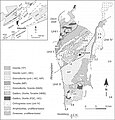
Geological map of the Odenwald (from: Altherr, 1999)

Geological map of the Odenwald (from: Stein, 2001)

Geological map of the Odenwald (Stein, 2001 + Weber, Geo-Naturpark)

Geological profile of the Odenwald (geo-nature park)

Rock cycle (geo-nature park)

Map (1914) of the regions of the drum granite and the Weschnitzplutons . Further cartographic representations and aerial photographs
.jpg)
_Odw7.jpg)


References and comments
- ↑ as Unit III in the structure at Eckardt Stein u. a .: Geology of the crystalline Odenwald - its magmatic and metamorphic development In: Annual reports and communications. Upper Rhine Geological Association. N.F. 83, 2001, pp. 89-111.
- ↑ Geological overview maps s. University of Frankfurt. Excursion report Odenwald (PDF).
- ^ Erwin Nickel: Odenwald - Vorderer Odenwald between Darmstadt and Heidelberg. (= Collection of geological guides. 65). 2nd Edition. Borntraeger, Berlin 1985, ISBN 3-443-15024-1 , p. 102.
- ↑ Hans Kreuzer, Wilhelm Harre: K / Ar age determinations on hornblinds and biotites of the crystalline Odenwald. In: GC Amstutz, S. Meisl, E. Nickel: Minerals and rocks in the Odenwald (= Der Aufschluss. Special Volume 27 (Odenwald)). Heidelberg 1975, pp. 71-77.
- ↑ Nickel, 1985, p. 22.
- ↑ Nickel, 1985, map p. 96.
- ↑ Nickel, 1985, p. 114.
- ↑ R. Altherr u. a .: Plutonism in the Variscan Odenwald (Germany): from subduction to collision. In: Int. J. Earth Sci. 88, 1999, pp. 422-443.
- ↑ Kreuzer u. a. 1975, pp. 75, 76.
- ↑ Further data from Carlo Dietl: Structural and Petrologic Aspects of the Emplacement of Granitoid Plutons: Case Studies from the Western Margin of the Joshua Flat-Beer Creek-Pluton (White-Inyo Mountains, California) and the Flasergranitoid Zone (Odenwald, Germany) . Dissertation . Heidelberg 2000.
- ↑ Nickel, 1985, maps p. 15, 100.
- ↑ Nickel, 1985, p. 102, maps p. 100, 101.
- ↑ a b c d University of Giessen. Petrological-geological excursion Odenwald 2005 ( Memento from December 11, 2012 in the web archive archive.today )
- ^ Gustav Klemm: Geological map of Hesse. Leaf Lindenfels . Hessian Geological State Institute. Recorded in 1931.
- ↑ Nickel, map p. 100 p. Nickel, 1985, map p. 64.
- ^ Gustav Klemm: Geological map of Hesse. Leaf Birkenau . Hessian Geological State Institute. Recorded 1899–1928. Revised by Eigenfeld in 1963. Nickel, 1985, map p. 64.
- ↑ Nickel, 1985, map p. 102.
- ↑ Nickel, 1985, p. 96.
- ↑ Nickel, 1985, p. 102, maps on p. XI and 15.
- ↑ Nickel, 1985, p. 16.
- ↑ Dietl, p. 196.
- ↑ Dietl, p. 194.
- ↑ Dietl, p. 215.
- ↑ H. Kreuzer, W. Harre: K / Ar age determinations on hornblende and biotites of the crystalline Odenwald. In: GC Amstutz, S. Meisl, E. Nickel (ed.): Minerals and rocks in the Odenwald . (= The Exposure. Special Volume 27). 1975, pp. 71-77.
- ↑ Dietl, p. 215.
- ↑ Todt u. a., 1995, p. Dietl, p. 216.
- ↑ Kreuzer and Harre (1975), Rittmann (1984), s. Dietl, p. 216.
- ↑ Cliff hikes: circular route 3, with a detour (white triangle and V) to the Ruttergsgrund , from the Tromm car park , circular route 9 of the Im Kreuz nature park east of Zotzenbach.
- ↑ Nickel, 1985, map p. 13.
- ↑ Nickel, 1985, p. 115.
- ↑ a b "A look into the stone archives of our region" at Geo-Naturpark Bergstrasse-Odenwald ( Memento from July 31, 2012 in the web archive archive.today )
- ↑ "The cycle of rocks: From granite to sandstone" at Geo-Naturpark Bergstrasse-Odenwald ( Memento from August 1, 2012 in the web archive archive.today )
- ↑ Overview map 1: 200,000 . In: Landesgeschichtliches Informationssystem Hessen (LAGIS).