
Forest head
| Forest head | ||
|---|---|---|
 |
||
| height | 538 m above sea level NHN | |
| location | Hessen , Germany | |
| Mountains | Odenwald | |
| Coordinates | 49 ° 32 '12 " N , 8 ° 46' 41" E | |
| Topo map | LAGIS Hessen | |
|
||
| rock | granite | |

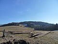
The forest head is 538 m above sea level. NHN high wooded mountain in the district of Löhrbach in the Odenwald in southern Hesse . It is on the border to Trösel in the south and Abtsteinach in the east. The Waldskopf is the highest elevation in the municipality of Birkenau in the Bergstrasse district .
Many Christmas trees are grown in a plantation on the southern slope of the Waldskopf . There is also one of the few vineyards in the Odenwald. On the south-western slope of the Waldkopf stands a holly , which is 13 meters high and between 170 and 180 years old and is one of the largest in Germany and is a protected species.
Waldskopf and Daumberg enclose the eastern part of Trösel, the so-called "Oberndorf".
Teufelstein natural monument

400 m southwest of the summit is the Teufelstein natural monument, a large boulder made of biotite granite . Together with other rocks , it forms a small sea of rocks , the shapes of which are a typical result of wool sack weathering . The Teufelstein is traversed by a 10 cm wide aplit passage , which protrudes slightly from the granite due to its greater resistance.
Two legends are linked to the Devil's Stone. In the first, the devil is said to have been tied to the rock with a strong iron chain. When the chain broke when he was freed, a deep furrow is said to have formed in the rock, which can still be seen today.
The second legend tells of a huge gold treasure that is buried under the devil's stone. Several times the farmers of the surrounding villages tried together to dig the treasure with hard work. The stone was almost overturned. However, the condition was that nobody was allowed to speak a word while working. Because some witches irritated and mocked the men, in the end a farmer let himself be carried away to a curse and the action failed at the last moment.
The field name Teufelstein has been used since the 19th century. In the Odenwald there is another Teufelstein, a rock formation near Reichenbach .
Images of the forest head

Waldskopf (with Christmas tree nursery)

View from the top

Waldskopf from the valley

Germany's largest holly ...

... is a natural monument
Waldskopf in winter


See also
Maps
- Hessian Land Surveying Office: TF 20-9, Der Überwald. Topographic leisure map 1: 20,000. Wiesbaden: Hessisches Landesvermessungsamt, 2000, ISBN 3-89446-293-0
Web links
- Gorxheimertal community to the holly, the devil stone and the legends
Individual evidence
- ↑ a b Map services of the Federal Agency for Nature Conservation ( information )
- ↑ "Am Teufelstein" in Löhrbach. Hessian field names. In: Landesgeschichtliches Informationssystem Hessen (LAGIS).
- ↑ "Am Teufelstein" in Trösel. Hessian field names. In: Landesgeschichtliches Informationssystem Hessen (LAGIS).