
Daumberg
| Daumberg | ||
|---|---|---|
 The Daumberg with part of Trösels |
||
| height | 462 m above sea level NN | |
| location | Hesse / Baden-Württemberg border , Germany | |
| Mountains | Odenwald | |
| Coordinates | 49 ° 31 '12 " N , 8 ° 45' 44" E | |
| Topo map | LAGIS Hessen | |
|
||
| Type | Extinct volcano | |

The Daumberg is an extinct volcano in the Odenwald with a height of 462 m above sea level. NN . The Daumberg is located in the south of the Trösel district in the municipality of Gorxheimertal near the border with Wünsch-Michelbach and thus on the border between Hesse and Baden-Württemberg .
Many Christmas trees are grown in several plantations on the Daumberg . The north slope of the mountain is used for skiing . The Grundelbach , a brook that gave its name to the Grundelbachtal community from 1971 to 1972, rises on the Daumberg and is now part of the Gorxheimertal community . There is a transmission mast on top, which gives the mountain its characteristic appearance. In addition, many extensive hiking trails open up the area on and around the Daumberg.
Daumberg and Waldskopf enclose the eastern part of Trösel , the so-called "Oberndorf".
Views

Daumberg in the fog
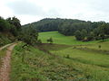
trail

Summit forest

Ski slope
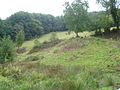
Sheep pasture

Daumberg from the street

View from the top


Remarks
- ↑ Christmas trees on a private website.
- ↑ The Daumberg in winter ( Memento from September 27, 2007 in the Internet Archive ) on the Gorxheimertal website.
- ↑ Hiking trails in the Gorxheimertal ( memento from September 27, 2007 in the Internet Archive ) on the Gorxheimertal website.
- ^ Map of Oberndorf on the website of the city publisher.
Maps
- Hessian Land Surveying Office: TF 20-9, Der Überwald. Topographic leisure map 1: 20,000. Wiesbaden: Hessisches Landesvermessungsamt, 2000, ISBN 3-89446-293-0