
Idolstone
| Idolstone | ||
|---|---|---|
 The Götzenstein from the southwest behind the valley cut of the Kallstädter Bach with Löhrbach |
||
| height | 521.9 m above sea level NHN | |
| location | Hessen , Germany | |
| Mountains | Odenwald | |
| Coordinates | 49 ° 33 '11 " N , 8 ° 46' 14" E | |
| Topo map | LAGIS Hessen | |
|
||
| rock | granite | |
| particularities | Natural monument | |

The Götzenstein is 521.9 m above sea level. NHN high wooded mountain in the district of Löhrbach in the Odenwald in southern Hesse , about 1.6 km northwest of Abtsteinach .
In the area of the summit there is a group of natural boulders made of granodiorite , which got their shape from wool sack weathering . It is protected as a natural monument. Since the summit area seems to be artificially flattened, an information board is said to have been a place of worship from the Celtic or Germanic times. Archaeological finds that date the flattening or confirm the interpretation as a place of worship are not known. In addition, the Franconian tribal leader Dietbert is said to have continued to pay homage to the old gods after Clovis I converted to Christianity around the year 500. The name Götzenstein has only been documented since the 19th century.
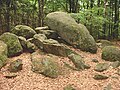
The rock formation on the Götzenstein

Götzenstein granite formation
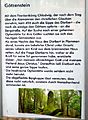
Götzenstein notice board


See also
Individual evidence
- ↑ a b Map services of the Federal Agency for Nature Conservation ( information )
- ↑ AM GOETZENSTEIN. Hessian field names. In: Landesgeschichtliches Informationssystem Hessen (LAGIS).