
Frankenstein complex

The northern part of the Crystalline Odenwald between Darmstadt and Seeheim in the west, the Reinheimer Bucht in the east and the SW-NE trending Seeheim- Groß-Bieberau shear zone , which separates this unit from the flaser granitoid zone to the south, is referred to as the Frankenstein complex . He consists of a. from gabbro rocks , which intruded in the Upper Devonian about 360 million years ago , and thus represents a stage of development of the Variscan mountain formation, the causes and course of which are outlined under the geology of the Odenwald .
Rocks of the Frankenstein Complex
The Crystalline Odenwald ends morphologically in the higher districts of Darmstadt (granidiorite, granite, G 2) and in a crystalline island to the northeast with outcrops on the Mainzer Berg (227 m, granite quarry) or in Messel and then dives in a northerly direction under the Sprendlinger Horst ( Messel hill country ). Granite under 260 m Rotliegendem has been proven by drilling near Sprendlingen .


The Frankenstein massif , which gives the complex its name, lies within a line Seeheim - Eberstadt - Ober-Ramstadt - Modautal -Seeheim and has a generally zoned structure: the gabbro ( anorthite 95-65) or eukrit (an 65-55) core is by diorite (anorthite content 55-40) and granite clods and these in turn enclosed by a slate gneiss coat . The mineralogical gabbro consists mainly of about 60% plagioclase , 20% clinopyroxene , 10% olivine .
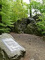
Such formations are still open in quarries where gabbro or diorite for building stones and road gravel were or are being mined: z. B. near Nieder-Beerbach , on Emmertsberg near Frankenhausen and on Wingertsberg (see picture below) near Nieder-Ramstadt (amphibolite / diorite).
Tectonic processes
By continental drift drifted in Devon - and carbon -time (about 380-320 million years ago) in a sea area between a large north and a southern continent crustal blocks ( Terrane ) and islands towards each other. As a result of the compressions, rocks were sunk deep into the earth's crust ( subduction ) and melted at a depth of approx. 15, sometimes even 30 to 50, kilometers , and second - together with magma rocks - slowly pushed back into the earth's crust, where the up to 1000 ° C hot melts 4 to 5 km below the land surface at that time gradually cooled and crystallized over the course of 60 million years. This is how the Variscan Mountains , to which the Odenwald belongs, and, as part of it, the Frankenstein complex came into being .
In the specialist literature, both the formation of the rock formations of the Frankenstein complex and the similarities with or the delimitation from the neighboring units of the crystalline Odenwald in connection with the tectonic processes are discussed:
- According to radiometric measurements, the Frankenstein gabbros intruded in the Upper Devonian approx. 360 million years ago: Both 207 lead / 206 lead age determinations on individual zircons (362 ± 9 million years) and 40 argon / 39 argon dates on hornblende (363 ± 7 million years ) and plagioclases (359 ± 3 million years) indicate, according to Kirsch, an intrusion age with a very quickly subsequent cooling history. Low strontium values (0.703) are characteristic of gabbro magma originating from the earth's mantle . Accordingly, the gabbro intrusion is interpreted in connection with a south-sloping subduction zone , which led to the formation of the magmatic arc of the Central German Crystalline Zone (MDKZ) and the Odenwald as part of it.
- Like Altherr, Stein delimits the Frankenstein Complex due to its tectonic-metamorphic history from the flaser granitoid zone adjoining it to the south : Radiometric dating shows a difference of 20 million years before the pluton began to take place in the flaser granitoid zone . This makes the Frankenstein-Gabbro complex the oldest igneous rock in the Bergstrasse Odenwald .
- Geochemical and structural data indicate a strike-slip shear zone ( suture zone ) between the Frankenstein Complex and the Flasergranitoidzone .
- There are also indications of different intrusion depths: the Frankenstein gabbro is interpreted as a mantle melt product, while all plutons in the adjoining southern part of the Bergstrasse Odenwald have a crust signature.

The geological formation of the Sprendlinger Horst , which adjoins the Frankenstein complex to the north , was created during the Rotliegend period . Already at the beginning of the erosion during the bulging of the Variscan Mountains , the later solidified weathered debris , known as arkose , mostly sandstones , Latvians and limestone , was deposited in ditches (Saar-Saale-Graben) and depressions on the northern edge of the mountainous region.
At the same time, great tremors in the earth's crust shook the Odenwald, volcanoes penetrated, v. a. in the north of the Frankenstein Complex , 290 to 270 million years ago from the earth, tuffs hurled out of their craters and poured lava on the sediment surface. Basalt-like rocks ( melaphyre ) are preserved near Dietzenbach, Urberach , Messel, (northeast of Darmstadt).
During Variscan and later (e.g. tertiary) tectonic processes, crevices tore open again and again in the rock mass. a. Younger aplites , calcite - barite - or copper - silver, cobalt - uranium melts penetrated, which crystallized into gangue rocks or veins like in the quarry on Wingertsberg near Nieder-Ramstadt . Gang rocks, odinite (= Spessartite), are also enclosed in the gabbro near Frankenstein Castle.
Geological maps
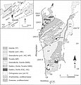
Geological map of the Odenwald (from: Altherr, 1999)

Geological map of the Odenwald (from: Stein, 2001)

Geological map of the Odenwald (Stein, 2001 + Weber, Geo-Naturpark)

Geological profile of the Odenwald (geo-nature park)

Rock cycle (geo-nature park)
.jpg)
_Odw7.jpg)


Today's landscape
Today's landscape in the northern Odenwald developed in the Tertiary , d. H. it is shaped on the one hand by the weathering processes and on the other hand by the rocks erupted during volcanic eruptions such as the trachyte in the eastern area towards Reinheimer Bucht z. B. at Eppertshausen , Dietzenbach and Heusenstamm , for which Lippolt determined a potassium-argon age of 65 to 69 million years. The basalt remains of the Roßberg volcano near Roßdorf , which are crushed to gravel in a quarry, were created around 42.5 million years ago. In addition, a former maar in the area of the Messel pit confirms the long-lasting earth movements in the region. There, the meeting of water and hot magma triggered a water vapor explosion that left a funnel lake up to 300 meters deep. This filled with deposits around 47 million years ago. a. also with animals and plants that were preserved as fossils in the later solidified clay stones .

The main reason for the current morphology in the area of the Frankenstein complex is the lowering of the Upper Rhine Rift . 45 million years ago tremors broke the area of today's Odenwald into mountain blocks and trenches. These tectonic processes were accompanied by an increase in volcanic activity in the entire western Odenwald, with a focus on the Sprendlinger Horst, v. a. on the western edge of the ditch between Langen and Egelsbach . The continually sinking Rhine valley also laid the erosion base for rivers and streams such as the Modau and its tributaries Waschenbach and Mordach / Beerbach and Darmbach , so that they increasingly cut into the rock. In the Sprendlinger Horst , Hengstbach / Grundbach, Heegbach and Silzbach dismantled the sandstones of the Rotliegend and the lava ceilings, the remains of which today form many hills as Härtlinge .
In addition, the warm, humid climate of this time favored weathering. So not only the mighty red sandstone layers that had deposited on the granite base of the mountains or the Rotliegend in the Mesozoic Era (more under Geology of the Odenwald ) were crushed and eroded by the rivers , but also the crystalline layers that were exposed again in the area of the Frankenstein complex Mountain hull. This also created the diorite or gabbro magnetic cliffs on the Langenberg ridge near the castle: The upper parts on the ridge tore into blocks and the subsequent chemical weathering dissolved their association from the edges so that they were surrounded by weathered gravel. These erosions continued in the subsequent Ice Age: downpours exposed the rocks and washed the gravel, sand and loam onto the slopes (debris cover) and into the valleys, where the streams lead to the subsidence areas, the Rhine Graben in the west and the Reinheimer Bay in the east, transported away and deposited there.

The Messeler Hügelland is the northernmost branch of the Crystalline Odenwald. View from its highest point, the Mainzer Berg , over the Rotliegend / Melaphyr area towards Darmstadt.
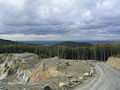
View from the quarry on Glasberg to north-northwest over the Rhine valley to the Taunus.
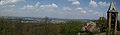
Frankenstein Castle and the northern Rhine plain towards Darmstadt

Northern slate gneiss zone of the Frankenstein complex : Nieder-Ramstadt with Wingertsberg quarry in the foreground. Above in the picture: Kirchberg-Lindenberg -Rücken north of Trautheim.
.jpg)


Natural monuments and climbing rocks
- Goethefelsen on the Herrgottsberg near Darmstadt
- Lindenberg rock groups near Trautheim
- Gabbro cliffs and rocks of the Frankenstein Magnetberg , see natural monument " Magnetsteine "
- Brohmfels of the gabbro magnetic cliffs on the eastern Frankenstein slope towards Nieder-Beerbach, see natural monument " Magnetsteine "

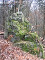
Brohmfels of the gabbro cliffs of the Frankenstein-Magnetberg .
Lindenberg rock on the Kirchberg-Lindenberg ridge north of Trautheim near Darmstadt (slate gneiss and Hornfelse between hornblende diorite and biotite diorite).
Goethefelsen on the Herrgottsberg near Darmstadt. Alternating storage of gray-green speckled Uralite diabase, amphibolite and calcium silicate rock.


literature

- GC Amstutz, S. Meisl, E. Nickel (ed.): Minerals and rocks in the Odenwald . (= Disclosure. Special volume 27). 1975.
- H. Kreuzer, W. Harre: K / Ar age determinations on hornblinds and biotites of the crystalline Odenwald. In: GC Amstutz u. a .: Minerals and rocks in the Odenwald. 1975, pp. 71-77.
- Hans J. Lippolt, István Baranyi, Wolfgang Todt: The potassium-argon ages of the post-Permian volcanic rocks of the north-eastern Upper Rhine Rift. In: GC Amstutz u. a .: Minerals and rocks in the Odenwald. 1975, pp. 205-212.
- Erwin Nickel : Odenwald - Vorderer Odenwald between Darmstadt and Heidelberg. (= Collection of geological guides. 65). 2nd Edition. Borntraeger, Berlin 1985.
- I. Noorbehesth, P. Paulitsch: On the dynamics of the Frankenstein massif. In: GC Amstutz u. a .: Minerals and rocks in the Odenwald. 1975, pp. 59-66.
- Paul Ramdohr : The silver cobalt ore with copper ores from Wingertsberg near Nieder Ramstadt. In: GC Amstutz u. a .: Minerals and rocks in the Odenwald. 1975, pp. 237-243.
- Eckardt Stein among others: Geology of the crystalline Odenwald - its magmatic and metamorphic development. In: Annual reports and communications. Upper Rhine Geological Association. NF 83, 2001, pp. 89-111.
- HD Trochim: The Gabbro Massif from Frankenstein. In: The opening. 2, special issue, 1955, pp. 41-47.
- HD Trochim: The Pluton of the Frankenstein (Odenwald) . Dissertation . Freiburg i. Br. 1960.
References and comments
- ↑ Unit I in the structure in R. Altherr and Eckardt Stein u. a .: Geology of the crystalline Odenwald - its magmatic and metamorphic development. In: Annual reports and communications. Upper Rhine Geological Association. N.F. 83, 2001, pp. 89-111.
- ↑ Geological overview maps s. Giessen University. Petrological-geological excursion Odenwald 2005 ( Memento from December 11, 2012 in the web archive archive.today )
- ↑ Geological overview maps s. University of Frankfurt, excursion report Odenwald (PDF)
- ^ Erwin Nickel: Odenwald - Vorderer Odenwald between Darmstadt and Heidelberg (= collection of geological guides. 65). 2nd Edition. Borntraeger, Berlin 1985, p. 168.
- ^ University of Giessen. Petrological-geological excursion Odenwald: Frankenstein - Pluton ( Memento from September 18, 2012 in the web archive archive.today )
- ↑ Images of the exposure of Frankenstein, s. University of Frankfurt, excursion report Odenwald 2005, p. 5.
- ↑ Geo-excursion Mainz Basin, Taunus, Odenwald , outcrop 11 cliffs below Frankenstein Castle east of Nieder-Beerbach, outcrop 12 south of Frankenstein Castle, outcrop 13 magnetic stones south of Frankenstein Castle, outcrop 14 overburden dump south of Frankenstein Castle, outcrop 15 forest clearing 1.5 km south Frankenstein Castle: see excursion report
- ↑ Geology in the Geo-Nature Park
- ↑ The Mühltal is extremely rich
- ↑ Pictures of the Niederbeerbach quarry, from "Petrological-geological excursion Odenwald 2005" of the University of Mainz ( Memento from September 18, 2012 in the web archive archive.today )
- ^ R. Altherr et al.: Plutonism in the Variscan Odenwald (Germany): from subduction to collision . In: Int. J. Earth Sci. 88, 1999, pp. 422-443.
- ^ Carlo Dietl: Structural and Petrologic Aspects of the Emplacement of Granitoid Plutons: Case Studies from the Western Margin of the Joshua Flat-Beer Creek-Pluton (White-Inyo Mountains, California) and the Flasergranitoid Zone (Odenwald, Germany) . Diss. Heidelberg 2000, p. 193 ff.
- ↑ H. Kirsch, B. Kober, HJ Lippolt: Age of intrusion and rapid cooling of the Frankenstein gabbro (Odenwald, SW-Germany) evidenced by 40Ar / 39Ar and singlezircon 207Pb / 206Pb measurements . In: Geologische Rundschau. 77, 1988, pp. 693-711. s. Dietl, p. 216.
- ↑ Kirsch u. a. 1986. s. Dietl, p. 191.
- ↑ Geological map of mGCR, s. Giessen University. Petrological-geological excursion Odenwald 2005 ( Memento from December 11, 2012 in the web archive archive.today )
- ↑ Henes-Klaiber 1992, Kreher 1994. s. Dietl p. 191.
- ↑ Eckardt Stein et al: Geology of the crystalline Odenwald - its magmatic and metamorphic development. In: Annual reports and communications from the Upper Rhine Geological Association. N.F. 83, 2001, pp. 89-111. s. Dietl, p. 216 f.
- ^ R. Altherr et al.: Plutonism in the Variscan Odenwald (Germany): from subduction to collision . In: Int. J. Earth Sci. 88, 1999, pp. 422-443.
- ↑ H. Kreuzer, W. Harre: K / Ar age determinations on hornblende and biotites of the crystalline Odenwald. In: GC Amstutz, S. Meisl, E. Nickel (ed.): Minerals and rocks in the Odenwald . (= Opening up special volume 27). 1975, pp. 71-77. s. Dietl, p. 216.
- ↑ Dietl, p. 216.
- ↑ Kirsch u. a. 1988, pp. 693-711. s. Dietl, p. 216.
- ↑ Altherr, 1999. s. Dietl, p. 216.
- ^ Paul Ramdohr: The silver cobalt ore with copper ores from Wingertsberg near Nieder Ramstadt. In: GC Amstutz, S. Meisl, E. Nickel (ed.): Minerals and rocks in the Odenwald . (= Opening up special volume 27). 1975, pp. 237-243.
- ↑ Stefan Meisl: Uranium mineralization and accompanying ore paragenesis in the Odenwald. In: GC Amstutz, S. Meisl, E. Nickel (ed.): Minerals and rocks in the Odenwald . (= Opening up special volume 27). 1975, pp. 245-248.
- ↑ a b University of Giessen. Petrological-geological excursion Odenwald 2005 ( Memento from December 11, 2012 in the web archive archive.today )
- ↑ a b "A look into the stone archives of our region" at Geo-Naturpark Bergstrasse-Odenwald ( Memento from July 31, 2012 in the web archive archive.today )
- ↑ "The cycle of rocks: From granite to sandstone" at Geo-Naturpark Bergstrasse-Odenwald ( Memento from August 1, 2012 in the web archive archive.today )
- ↑ Hans J. Lippolt, István Baranyi, Wolfgang Todt: The potassium-argon ages of the post-Permian volcanic rocks of the north-eastern Upper Rhine Rift. In: GC Amstutz, S. Meisl, E. Nickel (ed.): Minerals and rocks in the Odenwald . (= Disclosure. Special volume 27). 1975, pp. 205-212.
- ↑ Pictures outcrop of the quarry at Roßberg. P. 7: “Excursion report Odenwald 2005” of the University of Frankfurt
- ↑ map s. Lippolt, p. 207.
- ↑ AK Schmitt et al.: The onset and origin of differentiated Rhine Graben volcanism based on U-Pb ages and oxygen isotopic composition of zircon. In: Europ. J. Mineral. 19, 2007, pp. 849-857.
- ↑ s. Lippolt, p. 209 f.
- ↑ Cliff hike: circular route from the parking lot
- ↑ Nickel, 1985, p. 13.
- ↑ Brohmfels at Felsinfo des DAV ( Memento from February 11, 2013 in the web archive archive.today )
- ↑ Overview map 1: 200,000 . In: Landesgeschichtliches Informationssystem Hessen (LAGIS).