
Messel
| coat of arms | Germany map | |
|---|---|---|

|
Coordinates: 49 ° 56 ' N , 8 ° 45' E |
|
| Basic data | ||
| State : | Hesse | |
| Administrative region : | Darmstadt | |
| County : | Darmstadt-Dieburg | |
| Height : | 169 m above sea level NHN | |
| Area : | 14.82 km 2 | |
| Residents: | 4090 (Dec. 31, 2019) | |
| Population density : | 276 inhabitants per km 2 | |
| Postal code : | 64409 | |
| Area code : | 06159 | |
| License plate : | DA, TU | |
| Community key : | 06 4 32 012 | |
| LOCODE : | DE MSS | |
| Address of the municipal administration: |
Kohlweg 15 64409 Messel |
|
| Website : | ||
| Mayor : | Andreas Larem ( SPD ) | |
| Location of the municipality of Messel in the Darmstadt-Dieburg district | ||
  |
||

Messel is a municipality in the Darmstadt-Dieburg district in southern Hesse , northeast of Darmstadt .
geography
The community is 169 m above sea level. NHN , 9 km northeast of Darmstadt. The Kienswiesenteich in the north was created for fish farming.
Neighboring communities
Messel borders in the north on the cities of Dreieich and Rödermark (both Offenbach district ) and the municipality of Eppertshausen , in the east on the municipality of Münster (Hessen) and the city of Dieburg , in the south on the municipality of Groß -zimmer , the latter all in the Darmstadt-Dieburg district , and in the west to the city of Darmstadt.
Community structure
Messel only encompasses a district (Gmk.-Nr. 61104) and consists of the main town Messel and the residential area and district Grube Messel (not to be confused with the UNESCO World Heritage Site Messel Pit ).
history
prehistory
The district of Messel was visited by people even before the Neolithic and was also permanently settled from the Neolithic . Archaeological finds prove this, for example a bell beaker that was found on the Moret aisle.
In the Iron Age , Celts also settled in the Messel area. They too have left numerous traces. Southern Hesse was strongly influenced by the Roman occupation , and neighboring Dieburg developed into an economic center. Pottery, coins and handicrafts from this period have been preserved. A comprehensive change occurred with the beginning of the Germanic migration . 260 n. Chr. Broke through the Alamannen the limit. The Roman Empire gave up its areas on the right bank of the Rhine .
Territorial history and administration
With the beginning of the early Middle Ages , South Hesse came increasingly under Franconian influence. With the Christianization and the construction of the church, the area - also around Messel - received a new structure. The Lorsch Monastery , strongly supported by the Carolingian rulers, formed the regional power and cultural center. The oldest written mention of Messel comes from the year 800 from an entry in the Lorsch Codex under the name Massila .
A moated castle was built on the north-western edge of the village in the area of today's sports field in the "Ringelwoog" corridor . It dates back to around 1100. There is evidence of the building under Abbot Anselm von Lorsch . There are no more remains of the castle above ground. The almost leveled castle hill and a remnant of the surrounding moat are still preserved and are located near the Kneipp basin of the Trinkborn spring .
After the abolition of the Lorsch monastery in 1232, all of its property fell to the Archdiocese of Mainz . In 1303 the village belonged to the Röder Mark . In 1403 Henne Groschlag received the bailiwick over the place from the Counts of Katzenelnbogen as a fief . In 1455, Emperor Friedrich III. the Archbishop of Mainz the increase in the land tariff to Messel and Hesse . In 1490, Landgrave Wilhelm II of Hesse enfeoffed Ludwig Groschlag with goods in Messel. In 1495 Oswalt Groschlag owned a pond in Messel. The Lords of Groschlag thus accumulated a number of rights in Messel and thus became local lords until 1799, the year in which the last male member of this family died.
Now Messel was given as a fief to the Electoral Mainz Minister of State Franz Joseph Martin von Albini (1748-1816). The Messelers did not want to recognize him as local lords, but instead paid homage to the daughters of the last of the Groschlag family on May 31, 1799. Albini, however, forced his recognition by occupying the place with 50 Mainz hussars . However, Albini only remained local lord until 1806, when the place fell to the Grand Duchy of Hesse . However, the Albinis were patrimonial and thus also court lords of the place until 1821 . From May 15, 1822, the police rights and jurisdiction were exercised in the first instance by the state on behalf of Baroness Albini zu Dieburg. It was only as a result of the March Revolution of 1848 that the special civil rights were finally abolished with the “Law on the Relationships of Classes and Noble Court Lords” of April 15, 1848.
The statistical-topographical-historical description of the Grand Duchy of Hesse reports on Messel in 1829:
»Messel (L. Bez. Langen) Lutheran parish village; is located 2 St. from Langen, is surrounded by forest all around and belongs to the Freiherrl. Albini family. The place consists of 114 houses and has 652 inhabitants, who are Lutheran except for 11 Catholics and 84 Jews. - Messel, which formerly belonged to the knight canton of Odenwald and Röder Mark, was originally an Eppenstein-Königstein fiefdom owned by the Counts of Stolberg. But after the county of Stollberg came to Churmainz, the Groschlage were enfeoffed with Messel. In 1798 the Elector of Mainz granted the Minister of State von Albini the entitlement to the Groschlagchen fiefdom of Messel, which he received through the death of the Elector on May 25, 1799. Minister of State Friedrich Carl Freiherrn von Groschlag, as the last male descendant of this sex, also received. In 1806 Messel came under Hess. Your Highness. "
Until 1838 the parish of Ober-Roden held the minor tithe in Messel. In the middle of the 19th century the population increased considerably. After several bad harvests and famine, nearly 10% of the population left their hometown and immigrated to America.
Another major change was the discovery of the oil shale deposits , which had been exploited by the Messel trade union in the Messel pit since the 1870s . This was followed by manufacturing industrial plants which, together with the mine, became the main employer in the municipality for almost a century.
In the course of the regional reform in Hesse , the municipal area was expanded significantly to the south on January 1, 1977 by the law to reorganize the districts of Darmstadt and Dieburg and the city of Darmstadt . Until then, the southern municipal border followed the eastern part of the Zeilharder Grenzschneise , which was directed to the south-east, through the forests of the Dieburger Mark and in the western part the outflow that accompanied the edge of the forest to the south-west, about a hundred meters south of the Messel train station, crossed under Roßdörfer Strasse and a few hundred meters further from right into the Sülzbach or Silzbach , which flows westwards towards Wixhausen . The law made the Zeilharder Wald district , into which the formerly independent communities of Zeilhard , Georgenhausen and Klein -zimmer were divided in roughly equal strips from north to south , as well as the Spachbrücker Wald district to the south , which formed the community forest of Spachbrücken , incorporated into the municipality of Messel. The almost 500-meter-wide forest strip of the community of Klein-Zimmer north of the Spachbrücker and Klein-Zimmerer border aisles included the center of the fossil site of the Messel pit and the housing estate south of the Messel train station on Roßdörfer Strasse , which had around 300 inhabitants at the time.
The following list gives an overview of the territories in which Messel was located and the administrative units to which it was subordinate:
- 1303: Rödermark
- before 1799: Holy Roman Empire , Kurmainz , Bailiwick of the Barons Groschlag zu Dieburg
- from 1799: Holy Roman Empire, Kurmainz, Vogtei to Franz Joseph von Albini
- from 1803: Holy Roman Empire, Albinischer Ort (by Reichsdeputationshauptschluss )
- from 1806: Grand Duchy of Hesse (through the Rhine Confederation Act ), Albinian place
- from 1815: German Confederation , Grand Duchy of Hesse, Province of Starkenburg , Patrimonial Court Messel (Baron von Albini)
- from 1821: German Confederation, Grand Duchy of Hesse, Starkenburg Province, Langen District District (separation between justice ( Langen District Court ) and administration)
- from 1832: German Confederation, Grand Duchy of Hesse, Province of Starkenburg, District of Groß-Gerau
- from 1848: German Confederation, Grand Duchy of Hesse, Darmstadt administrative district
- from 1852: German Confederation, Grand Duchy of Hesse, Starkenburg Province, Darmstadt district
- from 1866: Grand Duchy of Hesse, Province of Starkenburg, District of Darmstadt
- from 1871: German Empire , Grand Duchy of Hesse, Province of Starkenburg, District of Darmstadt
- from 1918: German Empire, People's State of Hesse , Starkenburg Province, Darmstadt district
- from 1938: German Empire, People's State of Hesse, Darmstadt district (In the course of the regional reform in 1938 , the three Hessian provinces of Starkenburg, Rheinhessen and Upper Hesse were dissolved.)
- from 1945: American zone of occupation , Greater Hesse , Darmstadt district, Darmstadt district
- from 1949: Federal Republic of Germany , State of Hesse , Darmstadt district, Darmstadt district
- from 1977: Federal Republic of Germany, Land Hessen, administrative district Darmstadt, administrative district Darmstadt-Dieburg in which the administrative districts Darmstadt and Dieburg were dissolved in the course of the regional reform in Hesse .
Historical place names
In historical documents, the place is occupied with changing place names over the centuries : Massila (800); Massilia (813); Stehelin Mesela (1105); Messela (1303); Messele (1308); Messel (1358); Messeln (1438); Messel (1454); Meschell (1688); Mesßel (1688): Mescheln (1722).
History of religion
It is not known when a church was first built in Messel. The bell tower of today's Protestant church dates from the middle of the 15th century. The church was under the patronage of the Apostle Bartholomew . It was initially a branch church of Ober-Roden. Even before 1550, Messel was raised to an independent parish. In the early modern period, the church's central authority was the Archdeaconate of St. Peter and Alexander in Aschaffenburg, Landkapitel Rodgau .
With the Reformation , the Messel parish converted to the Lutheran faith, and the Lutheran Count von Hanau-Lichtenberg had the right to present the pastor. In 1560 Klein-Zimmer was separated from the parish association by the Archbishop of Mainz - perhaps because of this.
There has been a Jewish community in Messel since the 15th century. The Jewish proportion of the population in Messel fluctuated between 10 and 20%. The Messel synagogue was one of the oldest in the Grand Duchy. In 1830 it was replaced by a new building at Holzhäusergasse 20. In the era of National Socialism profaned and privatized, the building, one was half-timbered house , demolished in the 1970s.
As a Roman Catholic church was first the 1945 inaugurated Anthony - Chapel in the village of Messel. In 1957 the St. Boniface Church in Messel was inaugurated.
population
Population structure
According to the 2011 census , there were 3754 residents in Messel on May 9, 2011. 235 (6.3%) of these were foreigners, 79 of whom came from outside the EU , 104 from other European countries and 52 from other countries. The inhabitants lived in 1671 households. Of these, 473 were single households , 504 couples without children and 542 couples with children, as well as 115 single parents and 37 shared apartments .
Population development
| • 1829: | 652 inhabitants, 114 houses |
| • 1867: | 720 inhabitants, 133 houses |
| Messel: Population from 1829 to 2015 | ||||
|---|---|---|---|---|
| year | Residents | |||
| 1829 | 652 | |||
| 1834 | 665 | |||
| 1840 | 679 | |||
| 1846 | 707 | |||
| 1852 | 666 | |||
| 1858 | 653 | |||
| 1864 | 689 | |||
| 1871 | 707 | |||
| 1875 | 708 | |||
| 1885 | 728 | |||
| 1895 | 854 | |||
| 1905 | 1.011 | |||
| 1910 | 1,044 | |||
| 1925 | 1,129 | |||
| 1939 | 1,178 | |||
| 1946 | 1,610 | |||
| 1950 | 1,710 | |||
| 1956 | 1,779 | |||
| 1961 | 1.932 | |||
| 1967 | 2.224 | |||
| 1970 | 2,613 | |||
| 1972 | 2,334 | |||
| 1976 | 2,862 | |||
| 1984 | 3,676 | |||
| 1988 | 3,617 | |||
| 1992 | 3,887 | |||
| 2000 | 3,900 | |||
| 2005 | 3,916 | |||
| 2010 | 3,807 | |||
| 2011 | 3,754 | |||
| 2015 | 3,903 | |||
| Data source: Historical municipality register for Hesse: The population of the municipalities from 1834 to 1967. Wiesbaden: Hessisches Statistisches Landesamt, 1968. Further sources:; 1972 :; 1976 :; 1984 :; 1988 :; 1992 :; 2000 :; 2005 :; 2010 :; 2011 census; 2015: | ||||
Religious affiliation
| • 1961: | 1472 Protestant (= 76.19%), 426 Catholic (= 22.05%) inhabitants |
| • 2011: | 1649 Protestant (= 43.9%), 858 Catholic (= 22.9%) inhabitants |
Gainful employment
The municipality in comparison with the district, administrative district Darmstadt and Hesse:
| year | local community | district | Administrative district | Hesse | |
|---|---|---|---|---|---|
| Employees subject to social security contributions | 2017 | 665 | 74,525 | 1,695,567 | 2,524,156 |
| Change to | 2000 | + 3.9% | + 21.1% | + 16.1% | + 16.0% |
| of which full-time | 2017 | 69.8% | 68.3% | 72.8% | 71.8% |
| of which part-time | 2017 | 30.2% | 31.7% | 27.2% | 28.2% |
| Only marginally paid employees | 2017 | 212 | 15.305 | 224.267 | 372.991 |
| Change to | 2000 | +112.0% | + 14.4% | + 9.0% | + 8.8% |
| Branch | year | local community | district | Administrative district | Hesse |
|---|---|---|---|---|---|
| Manufacturing | 2000 | 44.8% | 41.1% | 27.0% | 30.6% |
| 2017 | 37.7% | 31.3% | 20.4% | 24.3% | |
| Commerce, hospitality and transport | 2000 | 28.1% | 26.1% | 26.4% | 25.1% |
| 2017 | 31.9% | 26.8% | 24.7% | 23.8% | |
| Business services | 2000 | 9.7% | 11.6% | 25.1% | 20.2% |
| 2017 | 10.5% | 17.1% | 31.6% | 26.1% | |
| other services | 2000 | 17.0% | 18.8% | 20.1% | 22.5% |
| 2017 | 19.8% | 23.6% | 23.0% | 25.4% | |
| Other (or without assignment) | 2000 | 0.3% | 2.4% | 1.4% | 1.5% |
| 2017 | 0.8% | 1.1% | 0.0% | 0.4% |
politics
Community representation
The local elections on March 6, 2016 produced the following results, compared to previous local elections:
| Parties and constituencies | % 2016 |
Seats 2016 |
% 2011 |
Seats 2011 |
% 2006 |
Seats 2006 |
% 2001 |
Seats 2001 |
||
|---|---|---|---|---|---|---|---|---|---|---|
| SPD | Social Democratic Party of Germany | 41.6 | 8th | 54.8 | 10 | 35.5 | 7th | 42.4 | 8th | |
| CDU | Christian Democratic Union of Germany | 45.9 | 9 | 37.0 | 7th | 54.4 | 10 | 49.1 | 9 | |
| FDP | Free Democratic Party | 12.5 | 2 | 8.2 | 2 | 5.9 | 1 | 8.6 | 2 | |
| FLoM | Free list of open messel | - | - | - | - | 4.2 | 1 | - | - | |
| total | 100.0 | 19th | 100.0 | 19th | 100.0 | 19th | 100.0 | 19th | ||
| Voter turnout in% | 60.1 | 60.1 | 59.9 | 67.6 | ||||||
mayor
After the Hessian municipal constitution is the Mayor Chairman of the Municipal Board , which in the municipality Messel next to the mayor five honorary Associate members. Mayor has been Andreas Larem (SPD) since December 13, 2010. His directly elected predecessors were
- 2000 to 2010 Udo Henke (CDU)
- 1994 to 2000 Reiner Fäth (SPD)
badges and flags

coat of arms
|
|
Blazon : "In divided blade Up In Blue three of red and silver geschachte oblique legal bar , down in gold a blue horseshoe." |
|
Foundation of the coat of arms: The coat of arms was designed in 1960 by head teacher Bezzenberger. The sloping beams should originally be tinged from right to left and the horseshoe black. The three red and white nested sloping beams on the blue field come from the coat of arms of the Groschlag von Dieburg , who were former local lords of Messel. The Horseshoe is already found on a seal from the 18th century. And symbolizes the rural character of Messel, with the national colors black and gold it should regarding the donation to the kingdom of Lorsch Abbey and that Messel in the area of the Imperial Wild spell Dreieich take was . |
flag
In the course of the approval of the coat of arms, the municipal flag was also officially awarded. This is described as follows: "On the wide white central strip of the red-white-red flag cloth, the municipal coat of arms."
The colors red-white-red are borrowed from the flag of the Grand Ducal Hesse and the Lords of Katzenelnbogen .
Culture and sights
Messel Pit
Messel is best known for the fossil site Messel Pit , which was declared a UNESCO World Heritage Site by UNESCO in 1995 . Since 2010 there has been a visitor information center at the entrance to the pit.
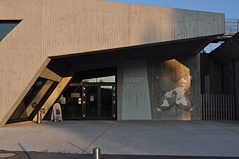
The Fossil and Local History Museum in Messel shows an exhibition on fossil finds , the mining, industrial and local history of Messel. The museum is located in the oldest known schoolhouse in the community, a building that was constructed in 1785.

Messel Fossils and Local History Museum
Messel Pit, entrance to the visitor and information center

Messel Pit,
August 2010
Messel station,
before 1907
Messel railway station and Messel paraffin and mineral oil plant,
around 1950


_CK-02.jpg)
_MR-12.jpg)
Nature and protected areas
In the east of the district there are parts of the nature reserve " Neuwiese von Messel " with species-rich forest meadows and rare plants. It is embedded in the larger Natura2000 area "Neuwiese and Wald northeast of Messel" (FFH area 6018-307). In the north lies a small part of the nature reserve " Hegbachaue bei Messel " in the municipality of Messel. It is also part of the Natura2000 area “Kranichsteiner Forest with Hegbachaue, Mörsbacher Grund and Silzwiesen” (FFH area 6018-305).
Regular events
- August: Curb (Always on the last weekend, the Sunday of which is still in August.)
Economy and Infrastructure
Land use
The municipal area covers a total area of 1482 hectares, of which in hectares are:
| Type of use | 2011 | 2015 | |
|---|---|---|---|
| Building and open space | 118 | 122 | |
| from that | Living | 62 | 65 |
| Business | 25th | 25th | |
| Operating area | 66 | 66 | |
| from that | Mining land | 0 | 0 |
| Recreation area | 40 | 36 | |
| from that | Green area | 16 | 16 |
| traffic area | 84 | 85 | |
| Agricultural area | 377 | 373 | |
| from that | moor | 0 | 0 |
| pagan | 0 | 0 | |
| Forest area | 713 | 717 | |
| Water surface | 10 | 10 | |
| Other use | 73 | 73 | |
traffic
The Messel train station is located in the Grube Messel district, on the Main-Rhein-Bahn , between Aschaffenburg and Wiesbaden via Darmstadt and Mainz . The rail connection has existed since 1858. The station can be reached from Messel via a combined foot and cycle path. There are on-site park and ride parking . In addition, the train station is served by buses to Darmstadt-Kranichstein (there connection to the Darmstadt tram ), Darmstadt-Oberwaldhaus and Rödermark. On the weekends there are individual bus connections to Heusenstamm via Dreieich - Offenthal .
Telephone code
Messel provides the telephone connection to the GSI Helmholtz Center for Heavy Ion Research , a major research facility located 3 km to the west in neighboring Darmstadt , as only the Messel local network still had a two-digit subscriber number available, including the 4-digit extension number in the GSI, in order not to exceed the length of the total number, which was limited in early international direct dialing . In a similar situation was for the Linz steelworks VOEST 2-digit 3-held area code temporarily a second, shorter, for - - 3-digit number with participants Linz created.
Personalities
Born in Messel
- Friedrich Koch (1786–1865), pharmacist and inventor of the industrial production of quinine
- Friedrich August Schäffer (1800–1867), educator and author of geographical and historical treatises
- Ernst Schaffnit (1878–1964), phytomedicist and university professor
- Rainer Emig (* 1964), English studies and university professor
With reference to Messel
- Adolf Spiegel (1856–1938), chemist, headed the exploitation of the oil shale in the Messel mine
- Hermann Harrassowitz (1885–1956), geologist, soil scientist, paleontologist and university professor, did research in the Messel mine
- Janheinz Jahn (1918–1973), writer and mediator of African literature, lived and died in Messel
- Jens Lorenz Franzen (1937–2018) paleontologist, head of the Senckenberg Research Institute in Frankfurt am Main, conducted research in the Messel mine
- Gerhard Storch (1939–2017), paleontologist, head of the Senckenberg Research Institute in Frankfurt am Main, did research in the Messel mine
- Michael Höllwarth (1944–2016), geologist, head of the Institute for Nature Conservation in Darmstadt, lived in Messel and was a founding member of the Messel Museum Association
literature
- Barbara Demandt: The medieval church organization in Hesse south of the Main = Writings of the Hessian State Office for Historical Regional Studies 29, p. 132.
- Siegfried RCT Enders: Monument topography Federal Republic of Germany - cultural monuments in Hesse - Darmstadt-Dieburg district . Braunschweig 1988, p. 300ff.
- Max Herchenröder : The art monuments of the district of Dieburg. 1940.
- Rudolf Knappe: Medieval castles in Hessen. 800 castles, castle ruins and fortifications. 3. Edition. Wartberg-Verlag, Gudensberg-Gleichen 2000, ISBN 3-86134-228-6 , p. 526ff.
- Wilhelm Müller: Hessian place name book . Volume 1: Starkenburg. 1937, pp. 458f.
- Hans Georg Ruppel (edit.): Historical place directory for the area of the former Grand Duchy and People's State of Hesse with evidence of district and court affiliation from 1820 to the changes in the course of the municipal territorial reform = Darmstädter Archivschriften 2. 1976, p. 143.
- Literature about Messel in the Hessian Bibliography
Web links
- Messel municipality. In: Internet presence of the Darmstadt-Dieburg district .
- Messel, Darmstadt-Dieburg district. Historical local dictionary for Hessen. In: Landesgeschichtliches Informationssystem Hessen (LAGIS).
- Information on the municipality of Messel. In: Hessisches Gemeindelexikon. HA Hessen Agency GmbH
- Link catalog on Messel at curlie.org (formerly DMOZ )
Individual evidence
- ↑ Hessian State Statistical Office: Population status on December 31, 2019 (districts and urban districts as well as municipalities, population figures based on the 2011 census) ( help ).
- ↑ a b c d e f Messel, Darmstadt-Dieburg district. Historical local dictionary for Hessen. (As of June 8, 2018). In: Landesgeschichtliches Informationssystem Hessen (LAGIS).
- ↑ The administration of justice and police with regard to the place Messel on May 15, 1822. In: Großherzoglich Hessisches Regierungsblatt No. 16 of May 29, 1822, p. 189.
- ↑ Law on the Conditions of the Class Lords and Noble Court Lords of August 7, 1848 . In: Grand Duke of Hesse (ed.): Grand Ducal Hessian Government Gazette. 1848 no. 40 , p. 237–241 ( online at the information system of the Hessian state parliament [PDF; 42,9 MB ]).
- ^ A b Georg Wilhelm Justin Wagner : Statistical-topographical-historical description of the Grand Duchy of Hesse: Province of Starkenburg . tape 1 . Carl Wilhelm Leske, Darmstadt October 1829, OCLC 312528080 , p. 154 ( online at google books ).
- ↑ Law on the reorganization of the districts of Darmstadt and Dieburg and the city of Darmstadt (GVBl. II No. 330–334) of July 26, 1974 . In: The Hessian Minister of the Interior (ed.): Law and Ordinance Gazette for the State of Hesse . 1974 No. 22 , p. 318 ff ., § 13 ( online at the information system of the Hessian state parliament [PDF; 1.5 MB ]).
- ↑ Geodata online and community boundary map from the Hessian Land Surveying Office as of July 1, 1972
- ^ Federal Statistical Office (ed.): Historical municipality directory for the Federal Republic of Germany. Name, border and key number changes in municipalities, counties and administrative districts from May 27, 1970 to December 31, 1982 . W. Kohlhammer GmbH, Stuttgart and Mainz 1983, ISBN 3-17-003263-1 , p. 354 .
- ^ Michael Rademacher: German administrative history from the unification of the empire in 1871 to the reunification in 1990. State of Hesse. (Online material for the dissertation, Osnabrück 2006).
- ^ Grand Ducal Central Office for State Statistics (ed.): Contributions to the statistics of the Grand Duchy of Hesse . tape 1 . Großherzoglicher Staatsverlag, Darmstadt 1862, DNB 013163434 , OCLC 894925483 , p. 43 ff . ( Online at google books ).
- ^ Thea Altaras : Synagogues in Hessen - What happened since 1945? . Königstein 1994, p. 131. ISBN 3-7845-7790-3
- ↑ a b Population by nationality group: Messel. In: Zensus2011. Bavarian State Office for Statistics , accessed in July 2015 .
- ^ Households by family: Messel. In: Zensus2011. Bavarian State Office for Statistics , accessed in July 2015 .
- ^ Ph. AF Walther : Alphabetical index of the residential places in the Grand Duchy of Hesse . G. Jonghaus, Darmstadt 1869, OCLC 162355422 , p. 56 ( online at google books ).
- ^ Local elections 1972; Relevant population of the municipalities on August 4, 1972 . In: The Hessian Minister of the Interior (ed.): State Gazette for the State of Hesse. 1972 No. 33 , p. 1424 , point 1025 ( online at the information system of the Hessian state parliament [PDF; 5.9 MB ]).
- ↑ Local elections 1977; Relevant population figures for the municipalities as of December 15, 1976 . In: The Hessian Minister of the Interior (ed.): State Gazette for the State of Hesse. 1976 No. 52 , p. 2283 , point 1668 ( online at the information system of the Hessian state parliament [PDF; 10.3 MB ]).
- ^ Local elections 1985; Relevant population of the municipalities as of October 30, 1984 . In: The Hessian Minister of the Interior (ed.): State Gazette for the State of Hesse. 1984 No. 46 , p. 2175 , point 1104 ( online at the information system of the Hessian state parliament [PDF; 5.5 MB ]).
- ^ Local elections in 1989; Relevant population figures for the municipalities as of October 25, 1988 . In: The Hessian Minister of the Interior (ed.): State Gazette for the State of Hesse. 1988 No. 45 , p. 2426 , point 1049 ( online at the information system of the Hessian state parliament [PDF; 4.6 MB ]).
- ↑ local elections 1993; Relevant population of the municipalities as of October 21, 1992 . In: The Hessian Minister of the Interior (ed.): State Gazette for the State of Hesse. 1992 No. 44 , p. 2766 , point 935 ( online at the information system of the Hessian state parliament [PDF; 6.1 MB ]).
- ↑ a b municipality data sheet : Messel. (PDF; 222 kB) In: Hessisches Gemeindelexikon. HA Hessen Agency GmbH
- ^ The population of the Hessian communities (June 30, 2005). In: Hessian State Statistical Office . Archived from the original .
- ^ The population of the Hessian communities (June 30, 2010). In: Hessian State Statistical Office . Archived from the original .
- ^ The population of the Hessian communities (June 30, 2015). In: Hessian State Statistical Office . Archived from the original .
- ↑ Religion: Messel. In: Zensus2011. Bavarian State Office for Statistics , accessed in July 2015 .
- ^ Result of the municipal elections on March 6, 2016. 432012 Messel. Hessian State Statistical Office, accessed in April 2016 .
- ^ Result of the municipal elections of March 27, 2011. 432012 Messel. Hessian State Statistical Office, accessed in November 2019 .
- ^ Result of the municipal elections on March 26, 2006. 432012 Messel. Hessian State Statistical Office, accessed in November 2019 .
- ↑ Results of the municipal elections of 2001 and 1997. (No longer available online.) Hessian State Statistical Office, archived from the original ; accessed in October 2019 .
- ↑ Mayoral elections in Messel. Hessian State Statistical Office , accessed in November 2019 .
- ↑ Mayor Andreas Larem was introduced to his office. In: Messeler Flapsch. January 2011, accessed August 4, 2016 .
- ↑ Interview with Messel's Mayor Larem. In: Frankfurter Rundschau. December 14, 2010, archived from the original ; accessed on August 4, 2016 .
- ^ Community welcomes new CDU mayor Henke. In: Rhein-Main-Zeitung. April 29, 2000, accessed August 4, 2016 .
- ↑ Staats-Anzeiger für das Land Hessen 1961, Official Gazette No. 13, page 356. Messel: coat of arms, flag (HStAD inventory R 6 C No. 173 / 1-2) In: Archivinformationssystem Hessen (Arcinsys Hessen).
- ↑ a b Brief history of the Messel community. In: website. Messel municipality, accessed November 2019 .
- ↑ Management plan (action plan) for FFH area 6018-307 "Neuwiese and Wald northeast of Messel". (PDF) Darmstadt Regional Council, December 20, 2011, accessed on July 24, 2020 .
- ↑ 6018-305 Kranichsteiner Forest with Hegbachaue, Mörsbacher Grund and Silzwiesen. Natura 2000 - Regulation of the Darmstadt Regional Council, accessed on July 24, 2020 .
- ↑ Sebastian Philipp. In: Darmstädter Echo , Wednesday, October 2, 2019, p. 24.
- ↑ Hessisches Statistisches Informationssystem In: Statistics.Hessen.

Alsbach cockerel | Babenhausen | Bickenbach | Dieburg | Eppertshausen | Erzhausen | Fischbachtal | Griesheim | Groß-Bieberau | Groß-Umstadt | Large rooms | Messel | Modautal | Mühltal | Münster (Hesse) | Ober-Ramstadt | Otzberg | Pfungstadt | Reinheim | Rossdorf | Schaafheim | Seeheim-Jugenheim | Weiterstadt