
Otzberg
| coat of arms | Germany map | |
|---|---|---|

|
Coordinates: 49 ° 49 ' N , 8 ° 54' E |
|
| Basic data | ||
| State : | Hesse | |
| Administrative region : | Darmstadt | |
| County : | Darmstadt-Dieburg | |
| Height : | 205 m above sea level NHN | |
| Area : | 41.95 km 2 | |
| Residents: | 6404 (Dec. 31, 2019) | |
| Population density : | 153 inhabitants per km 2 | |
| Postal code : | 64853 | |
| Primaries : | 06162, 06163 | |
| License plate : | DA, TU | |
| Community key : | 06 4 32 017 | |
| LOCODE : | DE OZG | |
| Community structure: | 6 districts | |
| Address of the municipal administration: |
Otzbergstrasse 13 64853 Otzberg |
|
| Website : | ||
| Mayor : | Matthias Weber ( independent ) | |
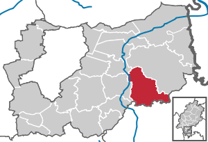
| Location of the municipality of Otzberg in the Darmstadt-Dieburg district | ||
  |
||

Otzberg is a municipality in the Darmstadt-Dieburg district in the Odenwald in southern Hesse . The municipality of Otzberg was created on December 31, 1971 through the amalgamation of six formerly independent municipalities as part of the regional reform in Hesse . All districts are located on the Otzberg , the namesake of the municipality, which is crowned by the Otzberg Fortress.
geography

location
The municipality of Otzberg is located in the northern Odenwald in southern Hesse , towards the flat Dieburger basin. The Otzberg, an extinct volcano towering over at 367 m above sea level. NN the area around 130 to 200 meters and is crowned by the Veste Otzberg. It represents a landmark in the northern Odenwald that can be seen from afar . When visibility is good, the view extends from here to Frankfurt am Main and the Taunus .
geology
The Otzberg is a residual volcano in the area of the Böllsteiner gneiss . It lies - and that is the reason for its formation - on an old fault zone (Otzberg gap), which continues to the south and the eastern → Böllsteiner from the 50 million years younger western Bergstrasse Odenwald (including the neighboring → Flasergranitoidzone to the west ) separates.
The Böllsteiner Gneiss and the Basalt- Otzberg were created by large movements of the earth's crust in two different geological ages :
- In the ancient times ( Paleozoic ) a southern continent migrated to a northern continent due to the continental drift. As a result, intermediate dwarf continents collided and in the Devonian and Carboniferous periods (around 380-320 million years ago) the Variscan mountains , to which the Odenwald belongs, was pushed back. The Böllstein Gneiss was already formed in the prehistory. It emerged from granitic rocks that penetrated into older sedimentary rocks from below about 410 million years ago as rock melt. As a result of the pushing together, these were sunk into deeper areas of the earth's crust and converted into slate and gneiss at high temperature pressure . At the Otzberg Fissure, these rocks welded together - in the further course of the plate collision - with those of the Bergstrasse Odenwald.
- Millions of years later, the mountain range had largely been eroded down to its hull and mighty → red sandstone , shell limestone , Keuper and Jura deposits had changed the landscape. In Central Europe there were again strong movements in the earth's crust: in connection with a Rift zone from the Mediterranean to the North Sea collapsed - in the Tertiary approx. 45 million years ago - the Upper Rhine Rift - and parallel to it the Erbacher - Michelstädter Rift. The Reinheim Bay also belongs to the subsidence area in the Rhine - Main area . As a result, many cross and transverse clefts divided the area of today's Odenwald into mountain blocks and trenches, so that magma masses could penetrate to the surface. This is how volcanoes such as the Otzberg arose in the central and northern Odenwald around 35-20 million years ago . Some crevices were filled with ore-bearing quartz and barite solutions .
- The volcanic cover - as well as the red sandstone, shell limestone, Keuper and Jura deposits - have now been removed by erosion . What remains are the basalt columns on the castle hill - as remains of the crater filling . The crystalline mountain hull was exposed again, rivers cut valleys and so today's landscape was formed.
Relics of the quarries and mines are evidence of the geological past:
- Basalt quarry for paving stone extraction on the Otzberg (see basalt columns)
- Feldspar mining for porcelain production: near Hering (1880)
- Schwerspatabbau ( barytes ) östl. Hering (1870)
- Iron ore mining has been documented since 1472: mining in the heavy spar veins near Zipfen and Wiebelsbach (from 1850) and in quartz iron veins south of Hering.
Expansion of the municipal area
The municipality of Otzberg is 41.95 km² and is one of the largest municipalities in the Darmstadt-Dieburg district. The municipal area has an extension of about 8 and 9.2 kilometers at the widest points.
Neighboring communities
In the north and east, Otzberg borders on the city of Groß-Umstadt , in the south on the communities of Höchst and Brensbach (both Odenwaldkreis ) and in the west on the city of Reinheim and the community of Groß-Zimmer .
Community structure
The community consists of the districts Habitzheim , Hering , Lengfeld (seat of the municipal administration) with Zipfen , Nieder-Klingen , Ober-Klingen and Ober-Nauses with Schloss-Naus.
history

Settlement around Lengfeld goes back to the Neolithic Age (5500 to 2500 BC). This is proven by finds made in 2008 in the Lengfeld building area of Pfarrers Dreispitz ( 49 ° 50 ′ 16 ″ N , 8 ° 54 ′ 5 ″ E ). Thousands of years old garbage pits were discovered there, in which, among other things, were also decorated pottery shards, the patterns of which are typical of the Rössen culture . Around 500 BC The inhabitants around Lengfeld belonged to the Celts .
The Romans also had settlements around the Otzberg. It is believed that they lived together with remnants of various Germanic tribes. They ruled the area until 260.
The Otzberg belonged to the villa autmundistat with accessories ( autmundistat = Umstadt, today Groß-Umstadt ), a Carolingian royal court that Pippin gave in 766 "with accessories" to the imperial abbey of Fulda .
Presumably, Count Palatine Konrad already exercised the bailiwick over the Fulda property on the northern edge of the Odenwald. It is certain that in 1214 the Fulda Upper Bailiwick passed to the Count Palatine via Umstadt and Höchst .
In a document from 1231, the Archbishop of Mainz, Siegfried III. As trustee of the Abbey of Fulda, the Count Palatine Otto II signed an agreement to share the Otzberg Castle . This is the first written mention of a castle on this hilltop. The areas around Otzberg finally went to Count Palatine Ruprecht II in 1390 .
In the course of the Landshut War of Succession , the Oberamt Otzberg went to Landgrave Wilhelm II of Hesse in 1504 , who took it militarily. He retired with 20,000 foot soldiers and 2,000 horsemen to Südhessen and made Hippe home and Wächterstbach (both are now deserted villages ) to the ground, the other places around the Otzberg thereof are not spared. As early as 1507 the Oberamt came back into the possession of the Palatinate.
In the course of the Thirty Years' War , Emperor Ferdinand II gave the Oberamt to Landgrave Ludwig V in 1626. Lengfeld remained in Hesse until the end of the war. The Peace of Westphalia of 1648 reassigned the old territories to the new Count Palatine Karl I. Ludwig .
In 1690 Johann Christoph Wagner's description of the Rhenish Palatinate says Der Pfaltz am Rhein. State = country = city = and history = mirror :
- Utzberg or Otzberg
- Is a Chur = Palatinate Ampt and castle away from the Rhine / near Franck = ford located / near Umstatt / in the Odenwald. To which the city Um = stadt also belongs. In the 30th Years of Teutonic War the Landgrave of Hesse Darmstadt took the two Aempter Utzberg and Umstatt for himself; But now the helper belongs to Chur = Pfaltz / the other helper belongs to Hessen = Darmstadt .
After the devastating war, the Electoral Palatinate pursued a policy of resettlement in its area characterized by religious tolerance. But the wars that broke out in the troubled times that followed, such as the War of the Palatinate Succession (1688–1697) and the War of Spanish Succession (1701–1714) destroyed many of the efforts and tens of thousands of Palatine emigrated and the like. a. to North America and Prussia.
From a religious point of view, too, the time after the Thirty Years' War was marked by great unrest. In 1685 the Reformed Palatinate-Simmern line died out and the Catholic cousins of the Palatinate-Neuburg line took over the government in the Electoral Palatinate with Elector Philipp Wilhelm . This ordered the equality of the Catholic faith in the predominantly Protestant Palatinate. Even during the War of the Palatinate Succession, France tried to advance the Counter-Reformation in the conquered areas and founded a number of Catholic parishes. The war ended in 1697 with the Peace of Rijswijk , which strengthened the position of the then reigning Catholic Elector Johann Wilhelm . This led to the decree of the Simultaneum on October 26, 1698 . According to this, the Catholics were entitled to use all reformed institutions such as churches, schools and cemeteries, while the reverse was not allowed. Furthermore, the reformed church administration, which had been independent until then, was subordinated to the sovereign. Only at the instigation of Prussia did the so-called Palatinate church division come about in 1705, in which the Simultaneum was reversed and the churches in the country, including rectories and schools, were divided between the Reformed and the Catholics in a ratio of five to two. There were special regulations for the three capitals Heidelberg , Mannheim and Frankenthal as well as the regional authorities Alzey , Kaiserslautern , Oppenheim , Bacharach and Weinheim . In cities with two churches, one should go to Protestants and the other to Catholics; in the others, where there was only one church, the choir was separated from the nave by a wall, and the one to the Catholics and the other to the Protestants. The Lutherans were only allowed those churches that they owned in 1624 or had built afterwards.
The Oberamt Otzberg remained in the Electoral Palatinate until 1803, when the Landgrave of Hesse-Darmstadt received the areas on the right bank of the Rhine through the Reichsdeputationshauptschluss .
Place name and administrative affiliation
In the historical documents, the Otzberg Castle, which gives it its name, is documented under changing names over the centuries (the year it was mentioned in brackets):
| Otzberg (1231) | Oetsperg (1322) | Oytsberg (1390) |
| Otsberg (1246, 1250, 1350, 1343, 1390) | Odisberg (1338, 1443) | Otisberg; Otzsperg (1399) |
| Othesberg (1251) | Odsberg (1381) | Otzberg; Oezberg; Otßberg, Otsberg, Otzsperg (1427) |
| Ottersberg (1257) | Otzpperg (1383) | Ottsburg (1608, 1632) |
The castle and place were administered as follows:
- 1305: Office Otzberg
- from 1390: Palatinate district castle ( Oberamt Otzberg )
- from 1803: Landgraviate of Hesse-Darmstadt , Principality of Starkenburg , Office of Otzberg
- from 1806: Grand Duchy of Hesse , Province of Starkenburg , Office Otzberg
- for more details see the history of the districts
- In 1971 the newly founded municipality belongs to the district of Dieburg .
- from 1977: District of Darmstadt-Dieburg, in which the district of Dieburg was dissolved in the course of the regional reform in Hesse
First mention of the districts
The places around the Otzberg were first mentioned in the 13th century, starting with the Veste Otzberg, which was named Othesberg in 1231 . With the mention of the castle men of the fortress Otzberg in 1244, Lengfeld was also mentioned. In 1261 Klingen was called Clingin , which of the two blades was meant is not known. Only in 1357 was a distinction made between Nieder-Klingen ( Nydern Clingen ) and 1383 Ober-Klingen ( Obern Clingen ). Habitzheim was first mentioned in a document in 1262 as Habuthisheim . Hering was first mentioned in 1322 as suburbium castri Oetsperg (lower town of Veste Otzberg). Nauses was already known under the name Nyuusaze in the 11th century. In 1357 Ober-Nauses was named as Obern-Nauweseste and in 1471 Schloß-Nauses as daz Sloßlin Nuwses . The youngest town in the Otzberg community is Zipfen, mentioned in 1784 as the Zipf .
History of the districts

Merger with the regional reform

In 1970 the state of Hesse decided to reorganize the districts and municipalities as part of the regional reform in Hesse , which had been discussed since 1969 . The parliamentarians knew that they could only break the resistance of the affected population with good arguments and interesting promises. One of the pledges was that congregations that had banded together by the end of 1971 could expect increased key allocations by 1980.
In addition to the six communities that make up the districts of Otzberg today, the representatives from Wiebelsbach also sat at the negotiating table. In the course of the discussions, Wiebelsbach turned to the city of Groß-Umstadt after a citizen vote.
Already in May 1971 the committee for the amalgamation of municipalities - local group Lengfeld agreed in principle on a border change agreement. The merger of the formerly independent communities Habitzheim, Hering, Lengfeld (with Zipfen), Nieder-Klingen, Ober-Klingen, and Ober-Nauses (with Schloß-Nauses) took place on December 31, 1971. For all formerly independent municipalities, local districts with local advisory boards and local councilors were formed in accordance with the Hessian municipal code. Lengfeld became the seat of the municipal administration.
The community of Otzberg continues to grow, so since the merger many more residential areas and, after a long struggle, an industrial area have been developed in order to better secure Otzberg financially.
population
Population structure
On June 30, 2006 the community had a total of 6936 inhabitants in about 2885 households. The residents are distributed as follows: Lengfeld with Zipfen: 2304 residents, Habitzheim: 1529 residents, Hering: 1025 residents, Ober-Klingen: 994 residents, Nieder-Klingen: 834 residents, Ober-Nauses with Schloß-Naus: 250 residents. All information relates to the number of inhabitants with secondary apartments.
According to the 2011 census , there were 6,309 inhabitants in Otzberg on May 9, 2011. Among them were 283 (4.5%) foreigners of whom 169 came from outside the EU , 63 from other European countries and 51 from other countries. The inhabitants lived in 2,614 households. Of these, 690 were single households , 730 couples without children and 916 couples with children, as well as 225 single parents and 53 shared apartments . 3173 inhabitants belonged to the Protestant (50.3%) and 1493 inhabitants of the Catholic (23.7%) denomination.
Population development
| Otzberg: Population from 1970 to 2015 | ||||
|---|---|---|---|---|
| year | Residents | |||
| 1970 | 5,472 | |||
| 1976 | 5,574 | |||
| 1984 | 5,671 | |||
| 1992 | 6,902 | |||
| 2000 | 6,300 | |||
| 2005 | 6,500 | |||
| 2010 | 6.354 | |||
| 2011 | 6,309 | |||
| 2015 | 6,357 | |||
| Sources: see the following list | ||||
- In 1970 the municipalities united in the municipality of Otzberg had 5472 inhabitants.
- In the local elections in 1977, as of June 1976, 5574 inhabitants were taken as the basis.
- In the local elections in 1985, as of June 30, 1984, 5671 inhabitants were assumed.
- The local elections in 1993 were based on 6902 residents as of March 31, 1992.
- The Hessian community encyclopedia names for the year 2000: 6300 inhabitants.
- According to the Hessian State Statistical Office, 6500 inhabitants lived in the Fischbachtal on June 30, 2005.
- The Hessian State Statistical Office reported for June 30, 2010: 8354 inhabitants.
- The 2011 census counted 6309 inhabitants.
- As of June 30, 2015, the Hessian State Statistical Office reports 6357 inhabitants.
Gainful employment
The municipality in comparison with the district, administrative district Darmstadt and Hesse:
| year | local community | district | Administrative district | Hesse | |
|---|---|---|---|---|---|
| Employees subject to social security contributions | 2017 | 862 | 74,525 | 1,695,567 | 2,524,156 |
| Change to | 2000 | + 54.8% | + 21.1% | + 16.1% | + 16.0% |
| of which full-time | 2017 | 63.8% | 68.3% | 72.8% | 71.8% |
| of which part-time | 2017 | 36.2% | 31.7% | 27.2% | 28.2% |
| Only marginally paid employees | 2017 | 283 | 15.305 | 224.267 | 372.991 |
| Change to | 2000 | + 31.0% | + 14.4% | + 9.0% | + 8.8% |
| Branch | year | local community | district | Administrative district | Hesse |
|---|---|---|---|---|---|
| Manufacturing | 2000 | 37.0% | 41.1% | 27.0% | 30.6% |
| 2017 | 29.2% | 31.3% | 20.4% | 24.3% | |
| Commerce, hospitality and transport | 2000 | 14.4% | 26.1% | 26.4% | 25.1% |
| 2017 | 15.2% | 26.8% | 24.7% | 23.8% | |
| Business services | 2000 | 7.9% | 11.6% | 25.1% | 20.2% |
| 2017 | 8.2% | 17.1% | 31.6% | 26.1% | |
| other services | 2000 | 33.9% | 18.8% | 20.1% | 22.5% |
| 2017 | 42.7% | 23.6% | 23.0% | 25.4% | |
| Other (or without assignment) | 2000 | 6.8% | 2.4% | 1.4% | 1.5% |
| 2017 | 4.6% | 1.1% | 0.3% | 0.4% |
religion
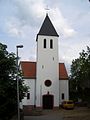
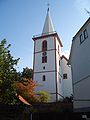
There are eight Christian houses of worship in Otzberg, three of which are Catholic and five are Protestant .
Protestant church
The parishes in Habitzheim and Lengfeld are connected with each other through parish offices. The Evangelical Church has a church in almost every district . Around 1786 residents are of Protestant denomination.
Hering forms a parish with Hassenroth ( municipality of Höchst ). In Hering there is also a Protestant church, built in 1900. About 420 Christians in Hering are Protestant.
Ober-Klingen and Nieder-Klingen each form a parish and are connected to the parish. While the church in Ober-Klingen is several centuries old, the church in Nieder-Klingen was consecrated in 1907. Ober-Klingen has about 1000 inhabitants, of which about 700 are parish members of the Protestant parish. Nieder-Klingen has around 750 inhabitants, around 600 of whom are Protestant.
The Protestant parishes are grouped together in the parish of Otzberg.
Catholic Church
In 2006 the parish group Otzberg was founded from the parishes of Hering and Habitzheim.
The parish of Habitzheim, Nieder-Klingen, Ober-Klingen and the Groß-Umstadt district of Semd belong to the parish of St. Cyriakus Habitzheim . There is a Catholic church in Habitzheim.
Hering, Lengfeld, Ober-Nauses, Schloß-Nauses and the Groß-Umstadt district of Wiebelsbach are connected in the parish of Maria Birth. The parish office is in Hering.
In Hering and Lengfeld there is a Catholic church.

Evangelical Church in Habitzheim

Catholic Church in Habitzheim

Evangelical Church in Hering
Catholic Church in Hering
Evangelical Church in Lengfeld

Catholic Church in Lengfeld

Evangelical Church in Nieder-Klingen

Evangelical Church in Ober-Klingen


politics
Community representation
The local elections on March 6, 2016 produced the following results, compared to previous local elections:
| Election year |
Electoral participation supply |
It accounted for the nominations of | ||||||||||||||
|---|---|---|---|---|---|---|---|---|---|---|---|---|---|---|---|---|
| CDU | SPD | Green | FDP | WGO | GALOB | All in all | ||||||||||
| % | % | Seats | % | Seats | % | Seats | % | Seats | % | Seats | % | Seats | % | Seats | ||
| 2016 | 53.2 | 39.7 | 10 | 31.3 | 8th | 13.6 | 3 | 15.4 | 4th | - | - | - | - | 100 | 25th | |
| 2011 | 56.2 | 42.7 | 13 | 32.9 | 10 | - | - | - | - | 12.0 | 4th | 12.4 | 4th | 100 | 31 | |
| 2006 | 54.5 | 48.5 | 15th | 32.4 | 10 | - | - | - | - | 11.2 | 4th | 7.9 | 2 | 100 | 31 | |
| 2001 | 60.6 | 51.7 | 16 | 35.4 | 11 | - | - | - | - | 6.2 | 2 | 6.7 | 2 | 100 | 31 | |
| 1997 | 73.9 | 48.3 | 15th | 31.9 | 10 | - | - | - | - | 13.4 | 4th | 6.5 | 2 | 100 | 31 | |
From 1972 to 1989 the CDU had an absolute majority of the 31 seats in the municipal council and always provided the mayor.
In 1989 the CDU lost its absolute majority and entered into one of the first black-green coalitions with the Green Alternative List Otzberger Bürger (GALOB) .
In 1997 the Otzberg Community of Voters ( WGO ), which emerged from a split from the SPD , moved into the Otzberg municipal council, but this did not change the majority. In the 2001 elections, the WGO lost half of its mandates.
Since then, the CDU again had an absolute majority in the municipal council until 2006. By 2011, the CDU and the Greens again formed a black-green coalition on the Otzberg. In the legislative period 2011–2016, the CDU cooperates with the WGO.
mayor
Acting Mayor
Matthias Weber (independent)
Former mayor
- 1972–1973 Johannes Saul, temporarily employed
- 1973–1989 Karl-Heinz Leonhardt (CDU)
- 1989–2000 Reinhard Müller (CDU), (died in office in 2000)
- 2000–2001 Vera Baier ( GALOB ), (took over the office of the late Mayor Müller as First Alderman )
- 2001–2013 Karl Ohlemüller (CDU),
Districts
The following local districts with local advisory board and local councilor according to the Hessian municipal code exist in the municipality:
- Habitzheim district (areas of the former Habitzheim community ). The local advisory board consists of five members.
- Hering district (areas of the former Hering municipality ). The local advisory board consists of five members.
- Lengfeld district (areas of the former Lengfeld municipality with the hamlet of Zipfen). The local advisory board consists of five members.
- Nieder-Klingen district (areas of the former Nieder-Klingen municipality ). The local advisory board consists of five members.
- Ober-Klingen district (areas of the former Ober-Klingen municipality ). The local advisory board consists of five members.
- District Ober-Nauses (areas of the former municipality of Ober-Nauses ). The local advisory board consists of three members.
badges and flags

coat of arms
|
|
Blazon : “Shield divided in blue and red (dividing line lowered) at the top a silver castle with an outer circular wall tapering upwards and an inner circular wall above it with a round central tower, a split shield placed on top of the outer circular wall and roughened blue and silver at the front back in gold contains a black "O" "
The coat of arms of the municipality of Otzberg approved on June 13, 1979 by the Hessian Ministry of the Interior , it was designed by the Bad Nauheim heraldist Heinz Ritt . In its design it follows the coat of arms of the old district of Dieburg . The castle represents the Veste Otzberg , with its round donjon, the highest point and symbol of the community. The small applied shield corresponds to the coat of arms of the Oberamt Otzberg , the blue-silver diamonds symbolize the historical affiliation to the Electoral Palatinate . |
flag
Together with the coat of arms, a municipal flag was also approved, which is described as follows:
"The municipal coat of arms is placed on the white central strip, covered by two blue side stripes in the upper half."
In the three-part division of the flag cloth, the flag refers to the former municipal flag of Lengfeld, the color scheme follows that of the coat of arms.
Partnerships
- Lencloître , Vienne department , France , since 1983
- Langenweißbach , Zwickau district , Germany , since 1990
Culture and sights
Museums


- The Museum for Odenwald Folk Culture has been located in the Old Town Hall in Lengfeld since 2009 (open every first Sunday of the month)
- The "Galeria Auto d´Epoca" car museum is located in the historic fire station in Lengfeld.
- The museum "Collection of Folklore in Hesse" on the Veste Otzberg has closed.
- The old forge is located in Lengfeld. Appointments are necessary to visit (Museum Collection for Folklore in Hesse)
Buildings
Veste Otzberg
The Veste Otzberg was on the summit of the mountain of the same name at 368 m above sea level. NN erected. The castrum Othesberg is mentioned for the first time in a document in 1231. The fortress is believed to have been built at the end of the 12th century / beginning of the 13th century.
The shape of the fortress is shaped by the double ring walls built in the 16th century, which describe an oval shape, and the keep, which is of Romanesque origin. The character is that of a fortress from the time after the introduction of artillery, typical castle features such as towers are completely absent.
Schloss-Naus moated castle
The moated castle Schloß-Naus is located in a valley southeast of the Otzberg. Originally, Naus Castle was built as a moated castle, but nothing can be seen of the fortifications and moats. Only the main house (mansion) and the gate tower have been preserved. The existing outbuildings were built in the 19th and 20th centuries.
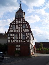
Old town hall in Lengfeld
The old town hall, which is located in the middle of the street , was built in 1717 and inaugurated under Mayor Johan Bastian Bauer. The town hall has been a listed building since 1905; it is two-story, with a large attic under the hipped roof . The basement is made of solid rubble stones with sandstone corner blocks. The upper floor was built in half-timbered construction. In the basement there is a passage in a north-south direction. Until 1973 the traffic was directed through the town hall and only then was a bypass of the town hall built. From 1974 the Museum of Folklore Hesse was located in the town hall, from 1984 to around 1999 the toy museum, a department of the Otzberg Museum, was set up there. From 2009 the Museum of Odenwald Folk Culture will be located there, also directed by Gerd J. Grein . In May 2020, a fundamental renovation of the building began, which also includes the interior areas.
Bundenmühle
In the "Bundenmühle" built towards the end of the 18th century, about half a kilometer outside ( map ), the television series These Drombuschs was filmed for ZDF between 1983 and 1993 . The mill house is now very dilapidated.
Other buildings or plants worth seeing
- Old town hall in Nieder-Klingen
- Former moated castle Habitzheim , today Hofgut
- Fortified Habitzheim cemetery complex
- The Catholic Church and the Burgmannenhaus in Hering
- Ev. Church in Lengfeld

The old town hall in Lengfeld

The Bundenmühle near Lengfeld
Old town hall in Nieder-Klingen

The former chapel and granary of Habitzheim Castle, now a converted house of the Habitzheim estate

The Burgmannenhaus in Hering

.jpg)


Parks and recreational areas
The since 1975 by the glee club down blades undeveloped Holler ditch in the district of Lower blade is a popular venue for public barbecues of the local clubs.
The junior camp site Junkerwald with a small stream offers children and young people a nature-loving leisure activity.
Nature and protected areas

The Taubensemd nature reserve of Habitzheim, Semd and Groß-Umstadt is partly in the Habitzheim district. In addition, there are two Natura2000 areas in the municipality of Otzberg , the FFH area forest south of Otzberg and parts of the FFH area grassland areas east of Brensbach .
The following are protected as natural monuments:
- The Friedenslinde ( summer linden tree ) in Nieder-Klingen (around 1871)
- Quarry with columnar basalt in herring
- Area around the Otzberg, a cone made of nepheline - basalt
There are also numerous caves such as the “ Rear and Front Kuhgraben ” in Lengfeld and Nieder-Klingen, as well as the “Kargenhölle”, “ Kuhtränke ”, “Mordkaute”, “Griesbusch”, “ Gaulsgräben ”, “Halde” and “ Felsenwiese am Kalkofen ” caves in Ober-Klingen are designated as natural monuments. The natural monument " Eichgraben bei Zipfen " is a former sandstone quarry.
See also the list of natural monuments in Otzberg
Regular events
- Christmas market in Hering on the 3rd and 4th weekend in Advent.
- Every September the Otzberg Summer Concerts, a chamber music series with young performers at the Veste Otzberg.
- Every three years Otzbergwoche in all districts.
Economy and Infrastructure
Land use
The municipal area covers a total area of 4195 hectares, of which in hectares are:
| Type of use | 2011 | 2015 | |
|---|---|---|---|
| Building and open space | 185 | 188 | |
| from that | Living | 123 | 124 |
| Business | 5 | 5 | |
| Operating area | 11 | 12 | |
| from that | Mining land | 1 | 1 |
| Recreation area | 13 | 13 | |
| from that | Green area | 5 | 5 |
| traffic area | 237 | 237 | |
| Agricultural area | 2672 | 2671 | |
| from that | moor | 0 | 0 |
| pagan | 0 | 0 | |
| Forest area | 1038 | 1038 | |
| Water surface | 25th | 25th | |
| Other use | 13 | 11 | |
Economic structure


In 2017 there were 862 employees in Otzberg, most of whom worked in the manufacturing industry, as well as in trade, hospitality, transport and public and private service providers. Only 5.7% of the employees worked in agriculture. There were 245 companies in Otzberg in 2016.
In Otzberg, in the district of Lengfeld, there is an industrial area of 150,000 m².
Established businesses
The most well-known company in specialist circles is probably Adolf Neubert's “Eurokart” company, which is dedicated to selling karts and accessories. Motorsport greats such as Michael Schumacher , Stefan Bellof , Bernd Schneider and Timo Glock drove for the company and were thus able to gain their first professional experience in motorsport.
Furthermore, Otzberg is today mainly characterized by small and medium-sized and agricultural businesses.
traffic
- Connection to the Odenwaldbahn (Frankfurt / Darmstadt - Erbach - Eberbach) at Otzberg-Lengfeld station.
- Bus connections in the direction of Groß-Umstadt and Höchst by bus route K 64 and bus route 678 in late-night traffic.
- The federal highway 426 runs through the municipality, the federal highway 45 is nearby .
- The Frankfurt airport is about 50 minutes away by car.
- The A 3 , A 5 , A 67 , A 45 and A 66 motorways can be reached quickly and easily.
media
The newspaper "Otzberg-Bote" is published for the community, a weekly newspaper (published on Thursday) that reports on the community and its districts. Club news and current news are also published there. It also acts as the official gazette of the Otzberg community.
The regional section of the Darmstädter Echo also reports irregularly about Otzberg.
education
- Hasselbach School in Habitzheim (primary school)
- Otzbergschule in Lengfeld (elementary, special, secondary and secondary school)
Others
A locomotive of the Hessian Ludwig Railway from around 1870 was named Otzberg .
Personalities
- Gerd J. Grein (born December 16, 1944 in Langen ) was museum director of the Otzberg Museum and a Hessian folklorist until 2008. Today he lives in Lengfeld.
- Karl Ernst Knodt (born June 6, 1856 in Eppelsheim , † September 30, 1917 in Bensheim ), poet and Protestant pastor of Ober-Klingen .
- Lambert Tobias Koch (born July 23, 1965 in the Hering district), economist and rector of the Bergische Universität Wuppertal
- Patrick Koch (born March 18, 1976 in Groß-Umstadt ) is a Hessian politician ( SPD ) and a former member of the Hessian state parliament . He has been the mayor of Pfungstadt since 2014.
- Christhard Richter (born July 13, 1938 in Niederlauken ), German writer who wrote the book Isch hab den Krieg nit made , which reproduces his childhood in Ober-Klingen during the Second World War .
- Horst Rumstedt (born January 30, 1921 in Sangerhausen ; † March 22, 1986 in Otzberg), painter and sculptor
- Willi Schissler (born December 12, 1949 in Nieder-Klingen ), German writer of regional crime novels .
- Michael Schumacher (born January 3, 1969 in Hürth - Hermülheim ), German automobile racing driver , completed an apprenticeship as a car mechanic in Otzberg and got his car driver's license there. He drove Eurokart for the Lengfeld racing team and gained various championship titles in karting (junior vice world champion and European champion). The later Formula 1 world champion also registered his residence in 1986 in Otzberg.
- Manfred Spitzer (born May 27, 1958 in Lengfeld ), German psychiatrist , psychologist and university professor .
literature
- Horst Bathon, Georg Wittenberger: The natural monuments of the Darmstadt-Dieburg district. (= Series of publications in the district of Darmstadt-Dieburg. Volume 3). 1986. ISSN 0179-0722
- Horst Rauch: Otzberg. In the mirror of old postcards. 1992, ISBN 3-89264-723-2 .
- Horst Rauch: Ober-Klingen. Beloved Ober-Klingen. 1988.
- Horst Rauch: Ober-Klingen. An archive tells. Volume 1-10.
- Horst Rauch: Ober-Klingen, the log book of the community. Volume 1-2.
- Christine Vonderheid-Ebner: Was it a new beginning? The political new beginning of the community of Lengfeld 1945–1949. 1987, ISBN 3-88758-020-6 .
- Kornelia Rossmann: Otzberg. 1980, (Publications on municipal science for the Darmstadt-Dieburg area, Series A: Community sociograms)
- Axel W. Gleue: Otzberg castle-fortress-barracks. 2003.
- Karl Georg Bundschuh, Annemarie Franz, Walter Gronwald, Jorden Jörns: Das Alte Lengfeld. Issue 1–10. 1998-2005.
- Link catalog on Otzberg at curlie.org (formerly DMOZ )
- Literature by and about Otzberg in the catalog of the German National Library
Web links
- Information on the community of Otzberg. In: Hessisches Gemeindelexikon. HA Hessen Agentur GmbH , 2016.
- Otzberg community. In: W appearance. Darmstadt-Dieburg district
- Otzberg, Darmstadt-Dieburg district. Historical local dictionary for Hessen. In: Landesgeschichtliches Informationssystem Hessen (LAGIS).
- Otzberg Castle, Darmstadt-Dieburg district. Historical local dictionary for Hessen. In: Landesgeschichtliches Informationssystem Hessen (LAGIS).
Individual evidence
- ↑ Hessian State Statistical Office: Population status on December 31, 2019 (districts and urban districts as well as municipalities, population figures based on the 2011 census) ( help ).
- ↑ Eckardt Stein u. a :: Geology of the crystalline Odenwald - its magmatic and metamorphic development. In: Annual reports and communications, Upper Rhine Geological Association. NF 83, 2001, pp. 89-111.
- ^ Wolfgang Franke: The mid-European segment of the Variscides: tectono-stratigraphic units, terrane boundaries and plate tectonic evolution. In: Geol. Soc. London Spec. Publ. 179, 2000, pp. 35-61.
- ↑ R. Altherr u. a .: Plutonism in the Variscan Odenwald (Germany): from subduction to collision. In: Int. J. Earth Sci. 88, 1999, pp. 422-443.
- ↑ G. Frenzel: The Nepheling Stone Sparagenesis of the Katzenbuckels in the Odenwald. In: Aufschluss. Special volume 27, Heidelberg 1975, pp. 213-228.
- ^ Erwin Nickel: Odenwald - Vorderer Odenwald between Darmstadt and Heidelberg. (= Collection of geological guides. 65). 2nd Edition. Borntraeger, Berlin 1985, ISBN 3-443-15045-4 .
- ↑ ( Page no longer available , search in web archives ) Report of the Darmstädter Echos from March 13, 2008.
- ↑ To the Castrum Othesberg. In: www.lifepr.de. UNITED NEWS NETWORK GmbH, accessed November 2019 .
- ↑ Reichsdeputationshauptschluss of February 25, 1803 - § 7
- ^ A b Castle Otzberg, Darmstadt-Dieburg district. Historical local dictionary for Hesse (as of July 16, 2014). In: Landesgeschichtliches Informationssystem Hessen (LAGIS). Hessian State Office for Historical Cultural Studies (HLGL), accessed on November 3, 2014 .
- ^ Heinrich Tischner: settlement names between the Rhine, Main, Neckar and Itter. In: www.heinrich-tischner.de. Private website, accessed November 2019 .
- ^ Federal Statistical Office (ed.): Historical municipality directory for the Federal Republic of Germany. Name, border and key number changes in municipalities, counties and administrative districts from May 27, 1970 to December 31, 1982 . W. Kohlhammer, Stuttgart / Mainz 1983, ISBN 3-17-003263-1 , p. 355 .
- ↑ a b main statute. (PDF; 334 kB) §; 6. In: Website. Otzberg community, accessed in July 2019 .
- ^ Statistics of the Otzberg community
- ↑ a b Population by nationality groups: Otzberg. In: Zensus2011. Bavarian State Office for Statistics , accessed in July 2015 .
- ^ Households by family: Fischbachtal. In: Otzberg. Bavarian State Office for Statistics , accessed in July 2015 .
- ^ Religious affiliation : Otzberg. In: Zensus2011. Bavarian State Office for Statistics , accessed in July 2015 .
- ^ Otzberg, Darmstadt-Dieburg district. Historical local dictionary for Hessen. (As of June 1, 2018). In: Landesgeschichtliches Informationssystem Hessen (LAGIS).
- ↑ Local elections 1977; Relevant population figures for the municipalities as of December 15, 1976 . In: The Hessian Minister of the Interior (ed.): State Gazette for the State of Hesse. 1976 No. 52 , p. 2283 , point 5671 ( online at the information system of the Hessian state parliament [PDF; 10.3 MB ]).
- ^ Local elections 1985; Relevant population of the municipalities as of October 30, 1984 . In: The Hessian Minister of the Interior (ed.): State Gazette for the State of Hesse. 1984 No. 46 , p. 2175 , point 1104 ( online at the information system of the Hessian state parliament [PDF; 5.5 MB ]).
- ↑ local elections 1993; Relevant population of the municipalities as of October 21, 1992 . In: The Hessian Minister of the Interior (ed.): State Gazette for the State of Hesse. 1992 No. 44 , p. 2766 , point 935 ( online at the information system of the Hessian state parliament [PDF; 6.1 MB ]).
- ↑ a b Community data sheet : Fischbachtal. (PDF; 222 kB) In: Hessisches Gemeindelexikon. HA Hessen Agency GmbH
- ^ The population of the Hessian communities (June 30, 2005). In: Hessian State Statistical Office . Archived from the original .
- ^ The population of the Hessian communities (June 30, 2010). In: Hessian State Statistical Office . Archived from the original .
- ^ The population of the Hessian communities (June 30, 2015). In: Hessian State Statistical Office . Archived from the original .
- ^ Result of the municipal election on March 6, 2016. Hessian State Statistical Office, accessed in April 2016 .
- ^ Result of the municipal election of March 27, 2011. 432017 Otzberg. Hessian State Statistical Office, accessed in November 2019 .
- ^ Result of the municipal election of March 26, 2006. 432017 Otzberg. Hessian State Statistical Office, accessed in November 2019 .
- ↑ Results of the municipal elections of 2001 and 1997. (No longer available online.) Hessian State Statistical Office, archived from the original ; accessed in October 2019 .
- ^ Otzberg voter community
- ^ Green alternative list Otzberg citizens
- ^ Hessian State Statistical Office: Election results 2011 and 2006
- ^ Hessisches Statistisches Landesamt: Election results 2001 and 1997
- ↑ Mayoral elections in Otzberg. Hessian State Statistical Office , accessed in November 2019 .
- ^ Approval of a coat of arms and a flag of the Otzberg community, Darmstadt-Dieburg district, dated June 13, 1979 . In: The Hessian Minister of the Interior (ed.): State Gazette for the State of Hesse. 1979 No. 27 , p. 1384 , item 722 ( online at the information system of the Hessian state parliament [PDF; 8.8 MB ]).
- ↑ Otzberg.de
- ↑ a b A new museum for Odenwald folk culture. In: FAZ.net. Frankfurter Allgemeine Zeitung GmbH, August 10, 2009, accessed November 2011 .
- ↑ Oldtimers move from Zimmer to Lengfeld. In: DA-imnetz.de. Pressehaus Bintz-Verlag, accessed November 2019 .
- ^ Echo Newspapers GmbH: Sale on the Veste Otzberg - Echo Online. Retrieved March 6, 2020 .
- ^ European Environment Agency (EUNIS): Forest south of Otzberg
- ^ European Environment Agency (EUNIS): grassland areas east of Brensbach
- ↑ Horst Bathon, Georg Wittenberger: The natural monuments of the Darmstadt-Dieburg district with biotope tours , 2nd expanded and completely revised edition. In: Schriftenreihe Landkreis Darmstadt-Dieburg, (Ed.) District Committee of the District of Darmstadt-Dieburg - Lower Nature Conservation Authority, Darmstadt, 2016. ISBN 978-3-00-050136-4 . 243 pages.
- ↑ Hessisches Statistisches Informationssystem In: Statistics.Hessen.
- ^ Otzberg community profile. (PDF; 327 kB) IHK Darmstadt , accessed in November 2019 .
- ↑ annual board of the company Euro Kart ( Memento of 28 September 2007 at the Internet Archive )
- ^ Program booklet “Season finale Schaafheim 1986” and VHS cassette from the company “Video-Maker” from this race

Alsbach cockerel | Babenhausen | Bickenbach | Dieburg | Eppertshausen | Erzhausen | Fischbachtal | Griesheim | Groß-Bieberau | Groß-Umstadt | Large rooms | Messel | Modautal | Mühltal | Münster (Hesse) | Ober-Ramstadt | Otzberg | Pfungstadt | Reinheim | Rossdorf | Schaafheim | Seeheim-Jugenheim | Weiterstadt