Lencloître
| Lencloître | ||
|---|---|---|

|
|
|
| region | Nouvelle-Aquitaine | |
| Department | Vienne | |
| Arrondissement | Châtellerault | |
| Canton | Châtellerault-1 | |
| Community association | Grand Châtellerault | |
| Coordinates | 46 ° 49 ′ N , 0 ° 20 ′ E | |
| height | 65-107 m | |
| surface | 19.04 km 2 | |
| Residents | 2,456 (January 1, 2017) | |
| Population density | 129 inhabitants / km 2 | |
| Post Code | 86140 | |
| INSEE code | 86128 | |
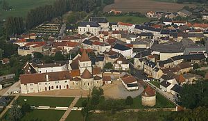
 Lencloître from a bird's eye view from the east |
||
Lencloître is a French commune with 2,456 inhabitants (at January 1, 2017) in the department of Vienne in the region Nouvelle-Aquitaine ; it belongs to the arrondissement of Châtellerault and the canton of Châtellerault-1 .
geography
The municipality is located around 30 kilometers north of Poitiers . Neighboring municipalities are Saint-Genest-d'Ambière in the north and east, Ouzilly in the south-east, Thurageau in the south and west and Doussay in the north-west.
The municipality is drained by the river Envigne with its tributaries Cursay and Sautard to the Vienne .
Community partnerships
literature
- Le Patrimoine des Communes de la Vienne. Volume 1, Flohic Editions, Paris 2002, ISBN 2-84234-128-7 , pp. 389-394.
Web links
Commons : Lencloître - collection of images, videos and audio files
