
Senillé-Saint-Sauveur
| Senillé-Saint-Sauveur | ||
|---|---|---|
|
||
| region | Nouvelle-Aquitaine | |
| Department | Vienne | |
| Arrondissement | Châtellerault | |
| Canton | Châtellerault-3 | |
| Community association | Grand Châtellerault | |
| Coordinates | 46 ° 49 ′ N , 0 ° 37 ′ E | |
| height | 57-146 m | |
| surface | 50.31 km 2 | |
| Residents | 1,877 (January 1, 2017) | |
| Population density | 37 inhabitants / km 2 | |
| Post Code | 86100 | |
| INSEE code | 86245 | |
| Website | http://www.senille-st-sauveur.fr/ | |

Senillé-Saint-Sauveur is a French village with 1,877 inhabitants (as of January 1 2017) in the department of Vienne in the region Nouvelle-Aquitaine (before 2016: Poitou-Charentes ); it belongs to the arrondissement of Châtellerault and the canton of Châtellerault-3 . It was created as Commune nouvelle with effect from January 1, 2016 through the amalgamation of the former municipalities Senillé and Saint-Sauveur , both of which have since had the status of a Commune déléguée in the new municipality .
structure
| District | former INSEE code |
Area (km²) | Population as of January 1, 2017 |
|---|---|---|---|
| Saint-Sauveur , administrative center | 86245 | 32.37 | 1,078 |
| Senillé | 86259 | 17.94 | 799 |
location
Senillé-Saint-Sauveur is about six kilometers east of Châtellerault . Neighboring municipalities of Senillé-Saint-Sauveur are Oyré in the north, Mairé in the northeast, Coussay-les-Bois in the east, Leigné-les-Bois in the east and southeast, Chenevelles and Monthoiron in the south, Availles-en-Châtellerault in the southwest and Châtellerault in the West.
Attractions
Saint-Sauveur
- Saint-Antoine church from the 14th / 15th centuries Century, since 1910/1913 Monument historique
- Remains of an ancient fortification wall, monument historique since 1932
- Commanderie Foucaudière
Senillé
- Saint-André church from the 12th century, restored in the 19th century
- Tuff quarry
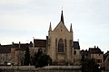
Saint-Antoine church in Saint-Sauveur
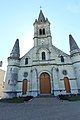
Saint-André church in Senillé

Commanderie Foucaudière


Web links
Individual evidence
- ↑ current population according to INSEE