
La Chaussée (Vienne)
| La Chaussée | ||
|---|---|---|
|
||
| region | Nouvelle-Aquitaine | |
| Department | Vienne | |
| Arrondissement | Châtellerault | |
| Canton | Loudun | |
| Community association | Pays Loudunais | |
| Coordinates | 46 ° 53 ' N , 0 ° 7' E | |
| height | 72-91 m | |
| surface | 13.58 km 2 | |
| Residents | 182 (January 1, 2017) | |
| Population density | 13 inhabitants / km 2 | |
| Post Code | 86330 | |
| INSEE code | 86069 | |

La Chaussee is a French village with 182 inhabitants (at January 1, 2017) in the department of Vienne in the region Nouvelle-Aquitaine (before 2016 Poitou-Charentes ); it belongs to the arrondissement of Châtellerault and the canton of Loudun (until 2015 canton of Moncontour ). The inhabitants are called Chausséens .
geography
La Chaussée is about 38 kilometers north-north-west of Poitiers . La Chaussée is surrounded by the neighboring communities of Aulnay in the north and north-west, Angliers in the north and north-east, Guesnes in the east and north-east, Verrue in the south-east, Saint-Jean-de-Sauves in the south and Saint-Clair in the west.
Population development
| year | 1962 | 1968 | 1975 | 1982 | 1990 | 1999 | 2006 | 2013 |
| Residents | 240 | 233 | 191 | 201 | 193 | 179 | 164 | 195 |
| Source: Cassini and INSEE | ||||||||
Attractions
- Saint-Pierre church from the 13th century with later alterations, monument historique
- Notre-Dame church in Le Petit-Chaussée from the 15th century, monument historique since 1926
- La Bonnetière castle from the 15th century, monument historique
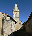
Saint-Pierre church

La Bonnetière Castle


Web links
Commons : La Chaussée - collection of images, videos and audio files