
Hollow cow trough (Otzberg)
|
Hollow cow trough
|
||
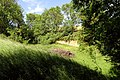
 Hollow natural monument "Kuhtränke": southern part with spring basin, wet meadow and loess tap |
||
| location | west of Otzberg - Ober-Klingen , Darmstadt-Dieburg district , Hesse | |
| surface | 8.0493 ha | |
| Geographical location | 49 ° 49 ' N , 8 ° 53' E | |
|
||
| Setup date | May 27, 1959 | |

The hollow "Kuhtränke" is an extensive natural monument in the municipality of Otzberg , Ober-Klingen district , in the Darmstadt-Dieburg district , southern Hesse. It was protected by ordinance of May 27, 1959 as a geological natural monument and bird sanctuary.
location
The hollow "Kuhtränke" is about 1.5 kilometers west of Ober-Klingen. The deeply cut loess gorge runs from south to north about 850 meters downwards. The natural monument is surrounded by meadows, paddocks and fields.
description
The hollow "Kuhtränke" is between 20 and 100 meters wide and 8 to 12 meters deep and has several short side valleys. In the southernmost section there is a meadow orchard with a spring depression and loess tap. This is followed by older tree populations (beech, hornbeam, birch, English oak, alder, individual conifers), celandine , wood anemones , violets and moisture-loving plants grow in the valley floor . In the lower third, a dam path leads across the hollow. To the south there is a rough meadow that was grazed by sheep for a time, where the fringed gentian was detected in the 1970s . The narrower northern section of the hollow is overgrown with cherry trees, oaks and bushes. Two loess bites offer nesting opportunities for wild bees and other ground-nesting insects. A meadow orchard was created in the northeastern part.
Numerous species of birds breed or live in the area, including turtle dove , honey buzzard , wryneck , small woodpecker , partridge , oriole , redstart , graycatcher and warbler species . 79 species of butterflies have been identified in the area.
In 1979 the area was proposed to be slightly expanded as a nature reserve of 10 hectares, but this was not implemented any further.

Course of the 850 m long hollow "cow trough"

Meager meadow grazed by sheep with fruit trees, behind the wooded loess gorge

northern part of the hollow with freshly planted orchards
western side valley with loess tapping

at the bottom of the northern Lösshohl


Impairments
The path is paved with rubble along the western edge of the protected area. Several nettle fields in the natural monument indicate the entry of drifted fertilizer from the adjacent fields. Compost deposits were observed in the southern part.
See also
Individual evidence
- ↑ a b c d e Horst Bathon, Georg Wittenberger: The natural monuments of the Darmstadt-Dieburg district with biotope tours. 2nd expanded and completely revised edition. In: District Committee of the Darmstadt-Dieburg District - Lower Nature Conservation Authority, Darmstadt (Hrsg.): Series of publications, Darmstadt-Dieburg district. 2016, ISBN 978-3-00-050136-4 . Pp. 114-118.
- ^ Ordinance on the safeguarding of natural monuments in the Dieburg district. (PDF; 26 kB) The district committee of the Dieburg district, May 27, 1959, accessed on June 5, 2020 .
- ↑ "Environmental Protection" map. BürgerGIS district of Darmstadt-Dieburg. Darmstadt-Dieburg district, accessed on June 5, 2020 .