
Heidelberg granite

The southern part of the Crystalline Odenwald between Weinheim and Heidelberg in the west and the red sandstone stage in the east is called Heidelberg granite . It crystallized in the Lower Carboniferous around 333 to 329 million years ago and thus represents a stage of development of the Variscan mountain formation, the causes and course of which are sketched under the geology of the Odenwald .
The main formations of the Heidelberg granite area
The leading rock, and thus eponymous for the southernmost region of the crystalline Odenwald, is a granite (pG) that appears porphyry in many ways due to large potash feldspars , in which the light-colored mixes quartz , potash feldspar and soda lime feldspar ( plagioclase ) with varying grain sizes predominate. The average mineralogical composition is 20–25% quartz, 30–35% potassium feldspar, 35–40% plagioclase, 5–10% biotite (dark mica) and is similar to that of drum granite , which contains around 10% more quartz and slightly less potassium feldspar . What both have in common is the infiltration of fine-grain aplit-like granite intrusions (G2), probably the youngest in the Odenwald. These replenishments have hardly any biotite, less plagioclase, but more potassium feldspar and quartz than the Heidelberg granite.

A precise demarcation to the northern drum granite is hardly possible, even if a mixed zone, the so-called clod agglomerate , south of a Weinheim- Wald-Michelbach line partially separates the areas. The clod agglomerate is an association of rocks (granite-granodiorite-diorite-slate-gneiss with diverse transitions), which were metamorphosed in the course of the mountain formation and dissolved by granite intrusions.
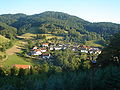
The pG / G2 distribution in the Heidelberg granite area is concentrated on the region on the edge of the mountain between Weinheim- Schriesheim and extends to the red sandstone step east of the drum granite in the fault zone of the Otzberg gap (see below) along the Ulfenbach valley, then in an arc (over Siedelsbrunn - Heiligkreuzsteinach - Vorderheubach - Altenbach ) swings southwest to Heidelberg and thereby covers the granites (further under Geology of the Odenwald ), which is indicated by some cuts in valleys (e.g. in the Eiterbach and Neckar valleys ). G2 occurs mainly in the eastern area of Lampenhain- Frontheubach-Heiligkreuzsteinach. This complex is interrupted by granodiorite, diorite / gabbro , slate gneiss as well as rhyolite and tuff islands, v. a. in a square between Ritschweier - Oberflockenbach - Unter-Flockenbach - Leutershausen -Ritschweier. To the south and east of Schriesheim volcanic rocks break through the granites or cover them.
Such formations are still open in quarries that produce building blocks and road gravel: Rhyolite is or was mainly mined near Weinheim (Wachenberg, 399 m above sea level ), Schriesheim (Ölberg) and Dossenheim , granite / granodiorite, for example, on the Steinberg near the Ursenbacher Height (granodiorite: 35% plagioclase, 25% reddish quartz, 25% potassium feldspar, 10% biotite and hornblende) A special case in the granite area of the Hohen Waid near Schriesheim is the pomegranate rock as an approx. 200 m long and 50 m wide lens in metamorphic rocks . The lime grenades were probably formed from silicate limestones through contact with the metamorphic environment.

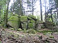
Rock formations on the northern slope of Eichelberg (southeast of Oberflockenbach): porphyry-like granite (pG) with large Kfs crystals and (local feature) reddish quartz

The granite cliff with rock castles and rock dumps stretches in a long band from the summit of the Eichelberg down the steep northern slope.
Wildeleutstein between Wünschmichelbach and Bärsbach (east of the Eichelberg ). According to a legend, forest people once lived in the cave , who helped the farmers with their work and received food in return.
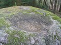
The fabulous creatures ate and drank from bowl-shaped eroded depressions in the granite stones.

Granite-granodiorite rock formation Steinerne Kanzel on the Kanzelberg east of Hirschberg-Großsachsen
Quartz fissure filling in the granite on the western Im Loh slope (Daumberg volcano area), prepared by weathering

Basement developed by the erosion of the Neckar: Granite cliff Russenstein am Haarlaß near Heidelberg


Tectonic processes
By continental drift drifted in Devon - and carbon-time (about 380-320 million years ago) between a northern and a southern continent small terranes and islands towards each other. As a result of the compressions, rocks were sunk deep into the earth's crust ( subduction ) and melted at a depth of approx. 15 kilometers , and secondly - together with magma rocks - slowly pushed back into the earth's crust , where they gradually cooled and crystallized over the course of 60 million years . This is how the Variscan Mountains, to which the Odenwald belongs, and as part of it the southernmost region of the Heidelberg granite with the above-mentioned granite and mixed rock zones came about.
In the specialist literature, both the origin of the various formations of the crystalline Odenwald and the delimitation from the neighboring units in connection with the tectonic processes are discussed. There are different opinions regarding the delimitation of the southern granite and granodiorite complexes from the central flaser granitoid zone . Like Altherr, Willner (1991) and Krohe (1994) describe a fault zone ( strike-slip zone ) as the boundary between the Flasergranitoidzone and the Weschnitzpluton and emphasize the differences between the intrusion structures: In the southern part of the Bergstrasse Odenwald, the intrusions rise as large ones urgent plutons, whereas they mostly form a close and complex connection to the central region. Therefore, they divide the Bergstrasse Odenwald into two independent tectonic-metamorphic units ( unit 2 and unit 3 ). Stein, on the other hand, summarizes the Flasergranitoidzone with Weschnitzpluton, Trommgranit and Heidelberg granite, since he could not determine a fault zone.

V. a. the radiometric measurements by Kreuzer and Harre, Rittmann (1984) and Todt (1995), which show neither a significant time difference between the intrusions nor between the peaks of the metamorphoses in both units : 235 uranium-207 lead and 238 uranium-206 lead dates on zirconia from Metamorphites that arose from sediments of the central (336–337 million years) and southern Bergstrasse Odenwald (342 million years, 332 million years) refer to thermal peaks of the regional metamorphosis. The subsequent cooling history is derived from the potassium-argon and 40 -argon -39-argon values of Hornblende (343-335 million years; 334 million years) and biotite (328-317 million years; 330 million years). Further evidence is listed under Flasergranitoidzone .
The igneous rocks formed in the time of the Upper Rotliegend about 260 million years ago, when great tremors in the earth's crust shook the Odenwald and volcanoes , v. a. in the area around Weinheim (Wachenberg ( 400 m above sea level ), Daumberg ), Schriesheim / Dossenheim (290-270 million years ago) and Heidelberg- Ziegelhausen , where old fault zones penetrated the earth, tuffs (e.g. between Schriesheim and Wilhelmsfeld detectable) and glowing clouds flung out of their craters and lava poured onto a flat, wavy granite-gneiss earth surface that was left over after the weathering of the Variscan mountains. This old Permian hull area is still visible in the Kanzelbachtal : to the east of Schriesheim on the Allmannsbacher Kopf (different spellings, including Allmesbach , 361 m above sea level ), at the Wendenkopf ( 359 m above sea level ) and on the Leichtersberg , red lying things are stored on the granite. Another evidence of the geological past is the rhyolite quarry Weinheim, where the solidified chimney filling of the Wachenberg volcano is processed into gravel. In Schriesheim / Dossenheim, on the other hand, the dismantling of the quartz-porphyry ceilings on the granite mountain hull has now been stopped. The eruption point of this volcano was presumably in the area of today's Rhine Graben and sank with all materials when it collapsed.

A relic of the sedimentation is found in Ziegelhausen: Zechstein from the era of the younger Perm , as the Zechstein Sea flooded the region and covered them with deposits, which are important for ore mining, as in the Dolomite later iron and manganese invaded quartz solutions.
The eastern border of the Heidelberg granite area is characterized by red sandstone deposits (lower B. in the Schriesheimer-Heidelberger area, the main peaks are in the middle or upper B., so in the Katzenbachtal near Schriesheim) from the Mesozoic ( Mesozoic Age) between 250 and 65 million years ( see also Buntsandstein-Odenwald ). At that time up to 600 m thick red sandstone, shell limestone - Keuper - and Jura layers were deposited, most of which are no longer preserved in the Odenwald, with the exception of the red sandstone e.g. B. the mountain ranges bordering the Neckar valley.
During Variscan and later (especially tertiary ) tectonic processes, cracks, v. a. in the western part near today's edge of the Rhine rift valley, again and again in the rock masses of crevices into which z. B. younger aplites, such as southwest of Altenbach, or melts penetrated and crystallized there to form dike rocks. Examples include a.
- the 2 km long Schwerspatgang in the Wide Valley east of Schriesheim (see picture below), the v. a. in the 19th century it was quarried and mined underground (until 1939) to obtain binding agents for the manufacture of paint and paper,
- an approx. 12 m thick quartz feldspar body in aplite granite of the Herrmannsgrund (north of the wide valley ), which was built in the 19th and early 20th century. was transported to a Frankenthal porcelain mill,
- the ore-containing (including copper) quartz - barite passages near Ursenbach, near Hohensachsen ( Marie mine in the Kohlbach ), Am Apfelberg in the valley to Ritschweier, in the Großsachsen area in the valley to Heiligkreuz or Am Haubenböhl near Gorxheim .
- Some of them were developed through mining, such as the silver, copper and iron mineralization zone in the biotite granite Am Branich (today visitor mine in Schriesheim) or the manganese deposits in the silicified Zechsteindolomite (see above) of the Mausbachtal near Ziegelhausen (see above).
Geological maps and profiles
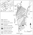
Geological map of the Odenwald (from: Altherr, 1999)

Geological map of the Odenwald (from: Stein, 2001)

Geological map of the Odenwald (Stein, 2001 + Weber, Geo-Naturpark)

Geological profile of the Odenwald (geo-nature park)

Rock cycle (geo-nature park)
.jpg)
_Odw7.jpg)


Today's landscape
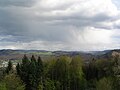
Today's landscape developed in the tertiary age. Triggered by the lowering of the Upper Rhine Rift 45 million years ago, tremors broke the area of today's Odenwald into mountain blocks and ditches. The continually sinking Rhine valley also laid the erosion basis for rivers and streams such as the Neckar or the Schriesheimer Kanzelbach, so that they increasingly cut into the rock. In addition, the warm, humid climate of this time favored weathering. Not only were the mighty layers of red sandstone and shell limestone , which were deposited on the granite base of the mountains in the Mesozoic Era (further under the geology of the Odenwald ), and eroded by the rivers , but also the crystalline mountain hull that was exposed again.
In this context, the granite rock cliffs on the Wildeleutstein and Eichelberg slopes ( 524 m above sea level ) to the west of Lampenhain were created : The upper parts on the ridge were torn into blocks and the subsequent chemical weathering rounded them off ( wool sack weathering ). First, they were surrounded by a 30 m deep Vergrusung later washed downpours the Grus on the slopes (talus) and into the valley where it is conveyed away the streams, and laid granite rock free, in Auftauphasen end of the Ice Age on the permafrost down slipped and formed boulder seas, e.g. B. on the steep slopes of the Eichelberg .
Natural monuments in the area of the Heidelberg granite
- NW side of the Wendenkopf near Schriesheim
- Strahlenburg above Schriesheim at the monument to fallen soldiers
- Former quarry below the Hirschburg near Leutershausen
- Stone pulpit near Hirschberg
- Granite cliffs on the Eichelberg slope (southeast of Oberflockenbach)
- Wildeleutstein or Wildeleutestein between Wünschmichelbach and Bärsbach
- Russenstein : Granite threshold under red sandstone formations at the foot of the Heiligenberg steep slope facing southeast on the Neckar near Heidelberg: theme park environment sandstone Odenwald-Hauberge and Winterhauch
- Granite rocks on Valerieweg near Heidelberg above the B 37: Theme Park Environment Sandstone Odenwald-Hauberge and Winterhauch
The Daumberg ( 462 m above sea level ) south of Trösels (Gorxheimertal) is the remainder (rhyolite, dust and glass tuff) of a volcano that broke through the granite basement when it erupted.
The summit region of the Daumberg with the double point and the central tub is reminiscent of extinct Auvergne volcanoes, but the chimney was higher at the beginning of the removal.
View from the Hirschkopf near Weinheim into the mixed zone between Tromm and Heidelberger granite: Kisselbusch / Götzenstein , Buntsandsteinstufe Hardberg - Stiefelhöhe , Buchklingen between Waldskopf and Geiersberg , mountains south of the Gorxheimer Valley (from left)

The mining relics of the Dossenheim volcano on the Sporenberg (from the Schauenburg), in the background the red sandstone mountains bordering the Rheingraben near Heidelberg

The up to 10 m deep gorge in the wide valley near Schriesheim marks a dismantled barite dike. It was created as a hydrothermal crevice filling (see above), in the process of which the granite frame rocks were decomposed or mylonitized by melting .


Geotours and rock collections in regional museums
- Minerals from the Odenwald: mansion of the Reinheim cultural center
- Weinheim-Schriesheim Geopark Path
- Rock cliff hike Eichelberg and Wildeleutestein : circular route 2 (return route: from Donnersberg change to circular route 3, again through the Haundelstal) from the Bärsbacher Weg car park in Wünschmichelbach
- Marie mine in the Kohlbach - historic lead and silver mine
- Visitor mine Anna-Elisabeth mine
- See also: List of mines in the Odenwald
Climbing walls
- Granodiorite / Granite - Jakobswand east of Weinheim in the Weschnitz Valley
- Rhyolite terraces on the Mount of Olives east of Schriesheim
literature

- GC Amstutz, S. Meisl, E. Nickel (ed.): Minerals and rocks in the Odenwald . (= Disclosure. Special volume 27). 1975.
- Geological natural monuments in the administrative district of Karlsruhe. Ed. LfU, 1999.
- Erwin Nickel : Odenwald - Vorderer Odenwald between Darmstadt and Heidelberg. (= Collection of geological guides. 65). 2nd Edition. Borntraeger, Berlin 1985.
- Eckardt Stein, Uwe Altenberger, Birgit Kreher-Hartmann: Geology of the crystalline Odenwald - its magmatic and metamorphic development . In: Annual reports and communications . Upper Rhine Geological Association, NF 83. 2001, ISSN 0078-2947 , doi: 10.1127 / jmogv / 83/2001/89, pp. 89–111.
- Geotopes: Crystalline basement, red lying, red sandstone . (on-line)
References and comments
- ↑ Unit III in the structure at Altherr or Stein, Eckardt u. a .: Geology of the crystalline Odenwald - its magmatic and metamorphic development. In: Annual reports and communications. Upper Rhine Geological Association, NF 83. 2001, pp. 89–111.
- ↑ Geological overview maps s. Giessen University. Petrological-geological excursion Odenwald 2005 ( Memento from December 11, 2012 in the web archive archive.today )
- ↑ Geological overview maps s. Excursion report Odenwald of the University of Frankfurt (PDF).
- ^ Erwin Nickel: Odenwald - Vorderer Odenwald between Darmstadt and Heidelberg. (= Collection of geological guides 65). 2nd Edition. Borntraeger, Berlin 1985, pp. 3 ff., 21 ff.
- ↑ Nickel, 1985, p. 22.
- ↑ View from the transmission tower of the White Stone in reverse direction to the north over the Heidelberg granite region and the Flasergranitoidzone (Fig. 8)
- ↑ Nickel, 66, maps on p. XI and 15.
- ↑ Nickel, 1985, p. 16.
- ^ Maps, Nickel, pp. XI, 64.
- ↑ Nickel, p. 52 ff.
- ↑ a b c Sandstein-Odenwald at the Ministry for the Environment, Climate Protection and the Energy Sector Baden-Württemberg ( Memento from September 12, 2012 in the web archive archive.today )
- ^ Wolfgang Franke: The mid-European segment of the Variscides: tectono-stratigraphic units, terrane boundaries and plate tectonic evolution. In: Geol. Soc. London Spec. Publ. 179, 2000, pp. 35-61.
- ↑ R. Altherr u. a .: Plutonism in the Variscan Odenwald (Germany): from subduction to collision. In: Int. J. Earth Sci. 88, 1999, pp. 422-443.
- ↑ Calo Dietl: Structural and Petrologic Aspects of the Emplacement of Granitoid Plutons: Case Studies from the Western Margin of the Joshua Flat-Beer Creek-Pluton (White-Inyo Mountains, California) and the Flasergranitoid Zone (Odenwald, Germany) . Dissertation . Heidelberg 2000, p. 196.
- ^ C. Dietl: Structural and Petrologic Aspects. 2000, p. 194.
- ^ C. Dietl: Structural and Petrologic Aspects. 2000, p. 215.
- ↑ H. Kreuzer, W. Harre: K / Ar age determinations on hornblades and biotites of the crystalline Odenwald .- In: GC Amstutz, S. Meisl, E. Nickel (ed.): Minerals and rocks in the Odenwald . (= Opening up special volume 27). 1975, pp. 71-77.
- ^ C. Dietl: Structural and Petrologic Aspects. 2000, p. 215.
- ↑ Todt u. a., 1995, p. C. Dietl: Structural and Petrologic Aspects. 2000, p. 216.
- ↑ Kreuzer and Harre (1975), Rittmann (1984), s. C. Dietl: Structural and Petrologic Aspects. 2000, p. 216.
- ↑ AK Schmitt et al.: The onset and origin of differentiated Rhine Graben volcanism based on U-Pb ages and oxygen isotopic composition of zircon . Europ. J. Mineral. 19, 2007, pp. 849-857.
- ↑ Pictures from the quarry on Mount of Olives near Schriesheim
- ↑ Pictures of the Sporenberg quarry
- ↑ Pictures from the Leferenz quarry near Dossenheim
- ↑ Tuffe von Dossenheim ( Memento from August 1, 2012 in the web archive archive.today )
- ↑ Outcrops on the southern slope of the Leichtersberg ( Memento from February 12, 2013 in the web archive archive.today )
- ↑ Pictures from the Leichtersberg
- ↑ Pictures of the Auerstein near Heidelberg
- ↑ Pictures outcrop at the turning head
- ↑ G. Frenzel: The Nepheling Stone Sparagenesis of the Katzenbuckels in the Odenwald . Aufschluss special volume 27, 213-228, Heidelberg 1975.
- ↑ Pictures of the wide valley east of Schriesheim
- ↑ Pictures of the Anna-Elisabeth mine
- ↑ Nickel, pp. 48, 69.
- ↑ a b University of Giessen. Petrological-geological excursion Odenwald 2005 ( Memento from December 11, 2012 in the web archive archive.today )
- ↑ a b "A look into the stone archives of our region" at Geo-Naturpark Bergstrasse-Odenwald ( Memento from July 31, 2012 in the web archive archive.today )
- ↑ "The cycle of rocks: From granite to sandstone" at Geo-Naturpark Bergstrasse-Odenwald ( Memento from August 1, 2012 in the web archive archive.today )
- ↑ Pictures: Geological window in the Heidelberg castle moat
- ↑ Nickel, 1985, map p. 13.
- ↑ scree of Rotliegenden on turning head
- ↑ Geological natural monuments in the administrative district of Karlsruhe. Karlsruhe 2000, p. 54. (PDF)
- ↑ Geological natural monuments in the administrative district of Karlsruhe. 2000, p. 52.
- ↑ Geological natural monuments in the administrative district of Karlsruhe. 2000, p. 52.
- ↑ Geological natural monuments in the administrative district of Karlsruhe. 2000, p. 48.
- ↑ Spatschlucht near Schriesheim
- ↑ Mineral Collection of the City of Reinheim ( Memento of the original from November 20, 2011 in the Internet Archive ) Info: The archive link was inserted automatically and has not yet been checked. Please check the original and archive link according to the instructions and then remove this notice.
- ↑ Stones, gorges and legends. Geopark path Weinheim-Schriesheim ( Memento from March 13, 2014 in the Internet Archive )
- ^ Pit "Marie in der Kohlbach" ( Memento from March 12, 2014 in the Internet Archive )
- ↑ Visitor mine "Grube Anna Elisabeth"
- ↑ Anna-Elisabeth mine , Schriesheim
- ↑ Jakobswand at rock info of the DAV ( Memento from June 23, 2012 in the web archive archive.today )
- ↑ Schriesheim at Felsinfo des DAV ( Memento from July 24, 2012 in the web archive archive.today )
- ↑ Overview map 1: 200,000 . In: Landesgeschichtliches Informationssystem Hessen (LAGIS).