Ritschweier
|
Ritschweier
City of Weinheim
|
|
|---|---|
| Coordinates : | 49 ° 31 ' N , 8 ° 42' E |
| Height : | 261 (228-324) m |
| Residents : | 305 (December 31, 2016) |
| Incorporation : | August 1, 1972 |
| Postal code : | 69469 |
| Area code : | 06201 |
|
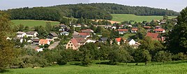
South view of Ritschweier
|
|
Ritschweier is a district of Weinheim in the Rhein-Neckar district and is located southeast of Weinheim in the western part of the southern, crystalline Odenwald . With around 340 inhabitants, Ritschweier is the smallest incorporation of the city of Weinheim. Ritschweier consists of the actual village of Ritschweier and the somewhat remote hamlet of Oberkunzenbach. The two districts have formed one community since the Middle Ages.
geography
Ritschweier is located in a valley running in east-west direction in the westernmost area of the crystalline Odenwald, only separated from the mountain road about three kilometers away by a ridge . The district is located at an altitude between 228 and 324 m above sea level. NN and covers an area of just over 191 hectares. 6% of these are built over, 33% consist of forest and 61% are used for agriculture.
history
It can be assumed that the Ritschweier valley was also settled at the time of the Franconian conquest . Oberkunzenbach, which belongs to Ritschweier, was first mentioned in 795 as Gunnesbach in the Lorsch Codex in a description of the Mark Heppenheim. The first written mention of Ritschweier himself, under the name Ruozelenswilre (hamlet of Rucelin), can also be found in the Lorsch Codex (document no. 3668) in connection with the recording of an interest levy : “In Ruozelenswilre 3 courtiers, 4 millers, 9 free Men and 14 women, 16 schillings ” . This document can be dated to around 1175, at which time the hamlet of Ritschweier was owned by the Lorsch Monastery .
With the dissolution of the Lorsch monastery in 1232, Ritschweier came into the possession of the Electorate of Mainz , from which it was first given as a fief to the Counts of Sayn zu Greiffenstein and from 1392 to the taverns of Erbach. In the 15th and in the first half of the 16th century ownership changed repeatedly until Ritschweier finally fell back to Erbach in 1539 and thus finally came into possession of the Palatinate .
With the Reichsdeputationshauptschluss of 1803, the place became part of the newly formed Grand Duchy of Baden . Here it received the status of an independent municipality in 1837, after it had been temporarily united with Rippenweier to one municipality in 1812.
On August 1, 1972, Ritschweier was incorporated into the city of Weinheim as part of the municipal regional reform and since then has formed a district there together with Oberkunzenbach.
Economy, infrastructure and population development
Throughout its history, including in modern times, Ritschweier has always been a purely agricultural place. Today it is developing more and more into a pure residential community, in which only one full-time agricultural business and two smaller part-time businesses exist.
Development of the population

politics
Local council
On the basis of the integration contract of 1972, Ritschweier forms a five-member local council that elects a local councilor and sends a representative to the Weinheim city council. After the local council election in 2019, the local council is composed as follows:
| Seats | |
| FWV | 4th |
| Pro Ritschweier | 1 |
Mayor
The current mayor is Karl-Friedrich Kippenhan.
coat of arms
The blazon of the coat of arms reads: In blue the silver Latin capital letter R.
It goes back to a court seal from 1673. At the suggestion of the General State Archives, it was accepted by the municipality in 1910. The colors refer to the Wittelsbachers of the Electoral Palatinate . After the Second World War, the community temporarily had a three-part coat of arms showing three ears of wheat, two apples and a plow. Since there was no official change and no colors were specified, Ritschweier returned to the official coat of arms in 1960.
traffic
Ritschweier is connected to the Hohensachsen and thus to the B 3 and A 5 via district roads. A bus line operated by WEBU, which is part of the VRN, and a call taxi connect Ritschweier to Weinheim city center via Hohensachsen and Lützelsachsen .
societies
- Fruit, wine and horticultural association Hohensachsen-Ritschweier
- DRK - local association Hohensachsen-Ritschweier
- Weinheim volunteer fire brigade , Ritschweier department
- Arbeiterwohlfahrt, local group Lützelsachsen-Hohensachsen and Ritschweier
Individual evidence
- ↑ Minst, Karl Josef [transl.]: Lorscher Codex (Volume 1), Certificate 6a, mid-August 795. In: Heidelberg historical stocks - digital. Heidelberg University Library, p. 59 , accessed on March 22, 2016 .
- ↑ Minst, Karl Josef [transl.]: Lorscher Codex (Volume 5), Certificate 3668. In: Heidelberger historical stocks - digital. Heidelberg University Library, p. 249 , accessed on March 22, 2016 .
- ^ Federal Statistical Office (ed.): Historical municipality directory for the Federal Republic of Germany. Name, border and key number changes in municipalities, counties and administrative districts from May 27, 1970 to December 31, 1982 . W. Kohlhammer, Stuttgart / Mainz 1983, ISBN 3-17-003263-1 , p. 477 .
literature
- Ortschaftsrat Ritschweier (ed.): Manual Chronicle of Ritschweier and Oberkunzenbach. o. O. 1982.
Web links
- Ritschweier on the website of the city of Weinheim
- Ritschweier on a private project page
Coordinates: 49 ° 31 '17 " N , 8 ° 41' 53" E

