
Reinheim hill country
| Reinheim hill country | |||
|---|---|---|---|
 |
|||
| Main unit group | 23 → Rhine-Main lowlands |
||
| Natural space |
231 → Reinheim hill country |
||
| Geographical location | |||
| Coordinates | 49 ° 50 '24 " N , 8 ° 51' 36" E | ||
|
|||
| state | Hessen , Bavaria | ||

The Reinheimer Hügelland describes a largely forest-free hilly landscape that naturally belongs to the Rhine-Main lowlands and represents the main unit 231.
The Reinheimer Hügelland stretches from Roßdorf southwards over Reinheim to Brensbach and from there over Otzberg and Groß-Umstadt northwards to Schaafheim . The average altitude is between 140 and 280 m above sea level. NHN . The natural area is divided into four sub-units and borders in the west on the Messel hill country ( Rhine-Main lowland ), in the north on the sub- maine level (Rhine-Main lowland) and in the south on the Vorderen- and Sandstoneodenwald ( Hessian-Franconian highlands ) . It is used almost exclusively for agriculture. In the area of the Kleine Bergstrasse there is fruit and wine growing ( Odenwälder Weininsel ).
Natural structure

The Reinheim hill country is divided as follows:
-
(to D53 - Upper Rhine lowlands )
-
(to 23 - Rhein-Main-Tiefland )
-
231 Reinheim hill country
- 231.0 Gersprenzgrund (8.99 km²)
- 231.1 Reinheim Basin (100.01 km²)
- 231.11 Roßdorf-Gundernhauser depression (16.77 km²)
- 231.12 Western Reinheimer Buckel (33.65 km²)
- 231.13 Southern Reinheimer Buckel (15.58 km²)
- 231.14 Eastern Reinheimer Buckel (32.03 km²)
- 231.15 Zipfener Ridge (1.98 km²)
- 231.2 Otzberger Randhügelland (16.36 km²)
- 231.3 Kleine Bergstrasse (38.02 km² + 13.45 km² in Bavaria.)
-
231 Reinheim hill country
-
(to 23 - Rhein-Main-Tiefland )
Geological structure
Especially in the western and eastern Reinheim humps (231.12, 231.14) the landscape is characterized by numerous loess hills . These are drifting sand dunes , the sand of which could be transported kilometers unhindered by the wind during the last glacial period, the so-called Vistula glacial period about 10,000 years ago, as the vegetation cover was still very patchy and in the form of a tundra . The dunes were also able to hike. However, this property quickly came to a standstill as a result of the reforestation after the last glacial period.

In the area of the Kleine Bergstrasse (231.3) and the Otzberger Randhügellandes (231.2) one encounters red granite and parts of andesite from the Carboniferous , which remained as the foundation of the former Variscan Mountains . In the area of the Otzberg (volcano) there is basalt ( Palaeogen - Neogen ) and southern red sandstone ( Triassic ).
In the southern Reinheim humps (231.13) there is largely red sandstone in the north and basalt in small areas, while the south is made up of granite, andesite and gneiss .
The Roßdorf-Gundernhäuser depression consists of loess, red sandstone, basalt and Rotliegend ( Permian ).

Loess-containing field on a drifting sand dune near Reinheim
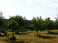
Fruit plantation on the Wingertsberg near Langstadt within the Kleine Bergstrasse (231.3)

Panorama in the area of the Kleine Bergstrasse (231.3)

Basalt summit of the Forstberg , in front of that Groß-Bieberau

The Reinheimer Hügelland with a view of the Veste Otzberg and the Otzberger Randhügelland


See also
Web links
- Reinheimer Hügelland with distinction from the NSG on the website of the NABU district association Dieburg
- Landscape profile Reinheimer Hügelland of the Federal Agency for Nature Conservation ( information )
Online maps
- Map and legend of the natural areas of Hesse (online copy of Die Naturraum Hessens , Otto Klausing 1988) in the Hesse Environmental Atlas of the Hessian State Office for Environment and Geology
- Otto Klausing: Geographical land survey: The natural spatial units on sheet 151 Darmstadt. Federal Institute for Regional Studies, Bad Godesberg 1967. → Online map (PDF; 4.3 MB)
- GeoViewer of the Federal Institute for Geosciences and Natural Resources ( information )
further reading
- Robert Yarham: Reading Landscapes. Recognize and understand the shapes of the earth's surface. , Haupt Verlag, 2012, ISBN 978-3-258-07695-9 . 256 pages
Individual evidence
- ↑ a b Map and legend of the natural areas of Hesse (online copy of Die Naturraum Hessens , Otto Klausing 1988) in the Hessen Environmental Atlas of the Hessian State Office for Environment and Geology
- ↑ Otto Klausing: Geographical land survey: The natural space units on sheet 151 Darmstadt. Federal Institute for Regional Studies, Bad Godesberg 1967. → Online map (PDF; 4.3 MB)
- ↑ Natural areas of the main unit groups 23, 14 and 35 in the Bavaria Atlas of the Bavarian State Government - Rhine-Main-Tiefland , Odenwald, Spessart, Südrhön and Rhön ( notes )