
Buntsandstein-Odenwald

The eastern, plateau- like part of the low mountain range of the Odenwald is referred to as Buntsandstein-Odenwald or Sandstein-Odenwald . It consists of the Triassic , continentally deposited sandstones of the red sandstone and borders in the west on the crystalline basement , in the northeast - separated by the Main - on the Spessart , in the east and south on the shell limestone formations of the building land and the Kraichgau . It represents the geological development of the region approx. 40–45 million years after the end of the Variscan mountain range (see also → Geology of the Odenwald ).
Red sandstone of the Odenwald

The Odenwald sandstones are part of the southwest German step landscape , which also includes the sandstone in the Spessart and the South Rhön. The layers continue to the west, interrupted by the Upper Rhine Rift , in the Palatinate Forest and northeast in an arc to Solling in the Weser Uplands . The demarcation of the plateau formations is only partially visible in the Odenwald geomorphologically , for example on the Rhine rift slope north and south of Heidelberg , on the edge of the northern depression area of the Lower Main Plain . In the east, the border appears as a step to the east of the crystalline basement in the Gersprenz or Ulfenbachtal , i.e. H. opposite the Böllsteiner Odenwald , Trommgranit and Heidelberger Granit . Here you can find differences of approx. 40-100 m compared to the western granitoid heights, apart from the areas around the Böllsteiner Höhe ( 416 m above sea level ) and the Trommgranitzentrum between Wagenberg and Tromm (535– 577 m above sea level ) , which are carved out as hardened zones protrude above the eastern red sandstone chain or at least lie on the same level (see pictures below). In contrast, taking the rock differences in two transition zones for limestone in the flat, sinking landscape hardly true, neither of the east to the land along the south-south line Wertheim am Main - Külsheim - Walldürn - Book - Neckar west of Mosbach still south to Kraichgau in the Kleiner Odenwald along the line Aglasterhausen - Schwarzach - Schönbrunn - Neckargemünd - Rohrbach .
The average 250 million year old Mesozoic sandstones are weathering materials of the Variscan Mountains, which have solidified into rocks due to the pressure of the layers above them. Backhaus estimates the deposition time to be around 15 million years, new geochronic assignments around 10 million years, they date the deposition of the red sandstones to the time from 253 to 243 million years ago.
Depending on the raw material, the rock has a different mineralogical composition. Because of the admixtures z. B. of iron or manganese minerals it usually shows red color or a yellowish to brown-black banding (tiger sandstone). But there are also bleached, white variants, such as those exposed in quarries south of the Spreng in the Hollerwald south-east of Ober-Kainsbach ( → Geopark educational trail: “Ore and heavy spar” ). Here the iron minerals were dissolved and washed out hydrothermally, i.e. by penetrating hot water.
The red sandstones differ according to the history of their deposition ( → sedimentation history and tectonic processes ) and according to their material composition ; in the specialist literature they are divided into lower (see below), middle (sm) and upper sandstone (see above) .
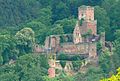
Freudenburg near Freudenberg am Main

Wertheim Castle on the Main
Zwingenburg near Zwingenberg am Neckar

Freienstein ruins on the western slope of the Gammelsbach valley .

Neckarsteinach, from the south, with the medieval Mittelburg (left) and Vorderburg.


In today's landscape , red sandstone formations are exposed in cliffs created by erosion and numerous former quarries (e.g. in Ulfenbachtal near Grasellenbach , in Steinachtal at the Stiefelhütte near Unter-Abtsteinach , in Olfen west of Beerfeldens), in which building blocks were broken. In the Neckar (Heidelberg Castle, castles near Neckarsteinach , Hirschhorn , Zwingenberg ) and Maintal ( Wertheim , Freudenburg ) in particular , the geological formation in the castles is culturally continued: the building material mostly comes from the neighboring area and was used when the neck ditch was created won.

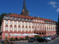
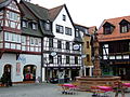
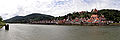
Heidelberg old town with castle, Heiliggeistkirche and old Neckar bridge.

Waldleinigen Castle south of Hesselbach
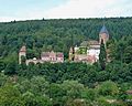
Erbach Castle

Facade of the monastery church in Amorbach

Main bridge gate in Miltenberg


The middle red sandstone is mainly used as a building material for churches, castles, palaces, town halls, schools, fountains, bridges, wayside shrines , decorative ornaments, window and door frames of many buildings, but also for historical institutions of justice (pillory in Erbach, gallows near Beerfelden).
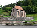
Spring church in Schöllenbach
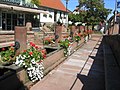
Market fountain in Michelstadt
The twelve-tube fountain ( Mümlingquelle ) in Beerfelden

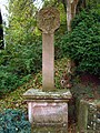
Marian column in beeches
Wayside shrine in Kirchzell-Watterbach

The building blocks for the Himbächel Viaduct near Marbach were cut in the Olfen quarry

Three-column gallows west of Beerfelder. In the background the plateau east of the Mümlingtal.

At the Bullauer Berg near Miltenberg hay pillars carved out of crystal sandstone (= giant pillars )


Sedimentation history and tectonic processes


The area of the Buntsandstein-Odenwald is still geologically shaped by the sedimentation period that followed the mountain formation: About 260 million years ago - the granite - gneiss mountain range has now largely been eroded - the so-called Zechstein Sea inundated and covered the Odenwald in the early Permian era it with deposits that have a marine character (e.g. clays and dolomites ) and are important for mining because iron and manganese-containing quartz and barite solutions later penetrated them. Relics from the Zechstein Age are still to the west of Ziegelhausen near Heidelberg, on the WNE slopes of the Morsberg ( Spreng , Bockenrod and Rohrbach - Erzbach , ( → Geopark educational trail "Bergbaulandschaft Reichelsheim" )), on the Kahleberg near Weschnitz and in the NE or S from Wald-Michelbach on the edge of the step under the lower red sandstone layer. In the 19th century, tunnels were driven in the ore-bearing Zechstein to mine iron and manganese.
The grain size distribution of the sedimentary rocks and the arrangement of the sands and boulders allow conclusions to be drawn about the deposition conditions. Regionally, there is a smooth transition between the clay deposits of the receding Zechstein Sea and those of the Lower Red Sandstone Age . The sand pouring continues and the proportion of the weathering material from the Variscan mountainous region - conglomerates, sand and clay stones - also increases in grain size, which in turn indicates a stronger flow energy. At the beginning of the embankments, the crystalline still protruded clearly from the environment, such as in the area of the Böllsteiner Odenwald ( Neustadt and Spreng). The early deposits ( → Geopark educational trail "Bergbaulandschaft Reichelsheim" clay pit Vierstöck ) are as mud flows (debris flows) from a wide area branched river system, the later as stratified floods of flood-carrying rivers, which flooded large areas and drained in ponds and shallow lake basins. Over the course of millions of years, z. B. in the middle Odenwald ( Michelstadt ), an average thickness of the su of 270 m.
The approximately 130–140 m high Middle Buntsandstein was mainly sedimented in the continental area, as the more strongly sinking marine basin edge had shifted to the north. According to the theory of continental drift, today's Central Europe was located in the dry belt of the earth, around 25 ° north latitude, and the weathering materials of the mountains were now deposited in flat and wide basins, which largely dried out in the times between the pouring periods. Such terrestrial-aquatic sedimentation is indicated by wave furrows or dry crack network strips in many outcrops (e.g. south of Spreng , in the Eberbacher (Breitenstein) or Strümpfelbrunner area) or plant roots and footprints of reptiles on the rocks, such as in Külsheim or Schreckberg near Mosbach ( → Geotours ). These finds match the coarser sands and conglomerates created by mechanical weathering (clastic), which were transported by rivers in lagoons or freshwater lakes and mixed with materials blown by the wind.

Current ripples ( Breitenstein near Eberbach) indicate flowing water, e.g. B. a river.

"Spherical sandstone", formed in the sediment by the separation of minerals from the pore water.

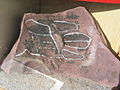
Plate made of "red quartzite" (upper red sandstone) with reptile footprints ( chirotherium ) near Külsheim.
Approx. 250 million year old footprint of a reptile from the family Erythrosuchidae in the middle main red sandstone (Middle red sandstone) near Eberbach.

Teufelskanzel near Eberbach am Neckar


The transition to the Upper Buntsandstein is seen as the high point of the terrestrial deposits , when the sedimentation area was increasingly flooded by the sea due to tectonic movements. An indication of this is the shell limestone marine fauna. The approx. 80 to 100 m high deposits resemble those of the Lower Buntsandstein due to their marine impact .

During the Mesozoic Era (Mesozoic Era) 250 to 65 million years ago, the Odenwald was covered not only by sand, but then also by layers of shell limestone, Keuper and Jura, up to a total of 600 m. (More under Geology of the Odenwald ). This is proven by Jura rocks that fell into the chimney when the Katzenbuckel volcano erupted around 55 million years ago and were trapped in the lava , sandstone remains on the edge of the Rhine ditch near Heppenheim and Heidelberg and the nepheline basanite chimney of the Forstberg near Groß-Bieberau. In addition, in the Mümlingtal near Steinbach and east of Michelstadt ( → Geotour Landschaft im Wandel ) there are also sunken clods of shell limestone with fossilized marine animals (including mussels, snails) and plants that were developed in open-cast mining and extracted for lime extraction.
During tectonic processes in the Mesozoic or Tertiary , crevices tore open again and again in the rock mass, into which melts then penetrated. This led to iron and manganese accumulations and excretions that filled gaps in the red sandstone. At times they were opened up by mining; near Gammelsbach (Eisenhammer west of Freienstein Castle ), Unterfinkenbach , east of Ober-Schönmattenwag in the Ulfenbachtal , near Momart ("Eisengrube", "Erzlöcher") and Zell ("Eisengrube"), near Bad König . Elsewhere, iron ore was enriched underground at the edge of a former volcanic vent, for example near Mömlingen . ( → Geotour Mömlingen )

Geological map of the Odenwald (Stein, 2001 + Weber, Geo-Naturpark)

Geological profile of the Odenwald (geo-nature park)

Rock cycle (geo-nature park)


Today's landscape
Today's landscape developed through the weathering processes in the Tertiary. Igneous rocks in areas of old fault zones v. a. on the Main and in the Neckar area on the edge of the depression towards the Kraichgau point to volcanic activities in connection with tectonic shifts in this geological age, e.g. B. the nepheline basalts of Katzenbuckels ( potassium-argon age from 53-55 million years) and the Kraichgau group (55-65 million) or the basalts on the Main (43-50 million).

Triggered by the lowering of the Upper Rhine Rift 45 million years ago, tremors broke the area of today's Odenwald into mountain blocks and ditches. The continually sinking Rhine Valley laid the erosion base for the rivers and streams deeper and deeper, so that they increasingly cut into the rock. The strongest erosion took place in the Tertiary, while the Neckar, for example, since the beginning of the Ice Age about 2 million years ago, has only moved 13 m further to today's level of 125 m above sea level. NN has dug. This is proven by the old Pleistocene gravel on the Ohrsberg , a former mountain near Ebersbach. In the previous millions of years, the river had u. a. cut into the area of the Hohe Warte ( 552 m above sea level ) almost 430 m deep, plus the layers above that have been cleared away today.
The warm and humid climate of the tertiary period favored weathering. In the western Odenwald, not only were the mighty layers of red sandstone and shell limestone crushed and eroded by the rivers, but also the crystalline mountain hull underneath. In the eastern Odenwald, however, a red sandstone landscape with steep slopes was left behind by two water networks, especially in north-south and north-east-south-west direction, in the Mümling, Mudau with Marsbach and Morre and Erfa to the Main and Steinach, Ulfenbach / Laxbach, Gammelsbach, Itter and Elzbach run to the Neckar. The erosion processes were favored by the great susceptibility of the sandstone to weathering. Its feldspars lose their strength due to kaolinisation and are washed out, so that new points of attack for loosening arise and the rock finally crumbles into sand.
Sandstone cliffs and gorges were created. The upper parts on the ridge tore into blocks, the subsequent chemical weathering decomposed them into small components. Later rains exposed the rocks and washed the sands and clay particles onto the slopes (debris cover) and into the valley, where the streams carried them away. In thawing phases at the end of the Ice Age, rocks slid down the permafrost and formed boulder seas, e.g. B. on the northern slopes of the Königstuhl above Schlierbach near Heidelberg. ( → natural monuments )
While the Böllstein gneiss ridge (left) hides the red sandstone formation, it is clearly recognizable as a step to the south of it (right) in the landscape of the Gersprenz valley ( Heidelberg , Morsberg , etc.) behind the gneiss or granitoid hills.

Red sandstone step in the Ulfenbachtal from the Tromm ridge towering over it

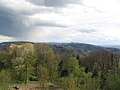
View from the Hirschkopf near Weinheim into the mixed zone. The red sandstone mountain range from Hardberg (transmitter mast) to Stiefelhöhe is visible as a higher step.
Behind the rhyolite Wachenberg (left) the granite-granitoid area between Weinheim (Geiersberg) and Schriesheim from the Hirschkopf , behind it: Buntsandstein-Berge ( white stone with tower) north of Heidelberg.

View from the former Katzenbuckel volcano (628 m) northwards over the red sandstone Odenwald


Natural monuments
- Theme park environment geotopes red sandstone
- Theme park environment sandstone Odenwald : Hauberge and Winterhauch:
- Red sandstone block heaps (especially the NSG Felsenmeer ) on the north or NE slope of the Königstuhl in the Heidelberg city forest, southwest of Schlierbach.
- Red sand quarry on the Neckarhalde
- Open red sandstone cliffs: The Felsenberg near Neckargemünd
- The Kranichsberg on the Neckar
- Felsenberg near Neckargemünd
- Lumpenfelsen near Eberbach
- Wolfsschlucht near Zwingenberg am Neckar
- Margarethenschlucht near Neckargerach
- On Bullauer Berg near Miltenberg, the Heunesäulen (= giant columns) have been located for centuries , which were probably carved in the Middle Ages from a particularly resistant formation of red sandstone, the crystal sandstone, but were not picked up (see picture above).
- Environmental theme park Geotop Katzenbuckel
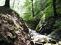
The Wolfsschlucht near Zwingenberg was created by tertiary and ice age weathering and erosion processes

The Margarethenschlucht near Neckargerach is an eroded, steep incision in the red sandstone step towards the Neckar
View of the historic town center with Hirschhorn Castle and the western bank of the Neckar, divided by tributaries.
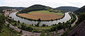
The Neckar valley from the Hinterburg near Neckarsteinach. On the other bank is the Dilsberg, which is closely entwined by the Neckar

Sea of rocks on the steep north slope between Königstuhl and Auerhahnenkopf near Heidelberg


Geotours
- Geopark educational trail in the Reichelsheim mining landscape (including the Vierstöck clay pit near Rohrbach)
- Geopark educational trail: ore and heavy spar (including Spreng sandstone quarry )
- Geopark path changing landscape near Michelstadt (including shell limestone outcrop with fossils, traces of mining)
- Geopark path The cultural and historical hiking trail Steinbach (including clay pit; hammer ensemble, iron smelting, mining in Steinbach)
- Geopark path The Amorbach sandstone path
- Geopark path fire and water in Mömlingen
- Geopfad Naturerlebnis Schreckberg (Mosbach)
- Rothenberg Geopark Path
- Geological trail path of crystals (genesis of Katzenbuckel)
Climbing walls
- Silberwald am Burzelberg north of Fau Nauses and east of Wiebelsbach
- East of Heubach in the Pferdsbachtal
- Hainstadt (Mümlingtal)
- Boot hut east of Unter-Abtsteinach
- Ziegelhausen east of Heidelberg
- Giant stone on the Gaisberg slope south of Heidelberg
literature
- GC Amstutz, S. Meisl, E. Nickel (ed.): Minerals and rocks in the Odenwald . (= Disclosure. Special volume 27). Heidelberg 1975, DNB 770582079 .
- in this:
- Egon Backhaus: The red sandstone in the Odenwald. Pp. 299-320.
- E. Becksmann: Tectonics of the overburden in the Odenwald. Pp. 281-283.
- G. Frenzel: The Nepheling Stone Sparagenesis of the Katzenbuckels in the Odenwald. Pp. 213-228.
- Hans J. Lippolt, István Baranyi, Wolfgang Todt: The potassium-argon ages of the post-Permian volcanic rocks of the north-eastern Upper Rhine Rift. Pp. 205-212.
- A. Semmel: Debris cover in the red sandstone Odenwald. Pp. 337-329.
- Erwin Nickel : Odenwald - Vorderer Odenwald between Darmstadt and Heidelberg. (= Collection of geological guides. 65). 2nd Edition. Borntraeger, Berlin 1985, ISBN 3-443-15045-4 .
- Volker Schweizer: Kraichgau and southern Odenwald . (= Collection of geological guides. Volume 72). Verlag Gebrüder Bornträger, 1982, ISBN 3-443-15031-4 .
cards

(1a) Western and northwestern borders of the Buntsandstein: north of Leimens - Heidelberg - Handschuhsheim - Heiligkreuzsteinach - Steinachtal to the north. (2c) Transition zone to the southern Muschelkalk area: along the Rohrbach - Neckargemünd - Schönbrunn - Schwarzach - Aglasterhausen line. Further cartographic representations and aerial photographs of the region:

(1b) Northern continuation of the red sandstone stage: east of Unter-Abtsteinach - Siedelsbrunn - Wald-Michelbach, east of the Ulfenbach valley to the north. Further cartographic representations and aerial photographs of the region:

(1c) Northern continuation of the red sandstone level: east of the Ulfenbachtal (Wald-Michelbach - Aschbach - Wahlen - Gras-Ellenbach) - east of Rohrbach - west of Kirch-Brombach - Kinzig - Hummetroth - arch north of the Mümlingtal to the Spessart. (2a) Transition zone to the eastern or southeastern Muschelkalk area along the south-southwest line Wertheim - Külsheim - Walldürn - Buchen. Further cartographic representations and aerial photographs of the region:

(2b) Southwestern continuation of the transition zone to the Muschelkalkgebiet: Eberstadt - Neckar west of Mosbach - area of the Kleiner Odenwald south of the Neckar along the line Aglasterhausen - Schwarzach - Schönbrunn - Neckargemünd - Rohrbach (see 2c). Further cartographic representations and aerial photographs of the region:


Web links
- Website of the Odenwald Geopark with maps and pictures; accessed on October 23, 2013
References and comments
- ↑ Egon Backhaus: The red sandstone in the Odenwald. In: GC Amstutz, S. Meisl, E. Nickel (ed.): Minerals and rocks in the Odenwald . (= Opening up special volume 27). 1975, p. 317.
- ^ Erwin Nickel: Odenwald - Vorderer Odenwald between Darmstadt and Heidelberg . (= Collection of geological guides. 65). 2nd Edition. Borntraeger, Berlin 1985, p. 10 ff.
- ↑ G. Klemm (Geological map of Hessen. Blatt Erbach. Hessische Geologische Landesanstalt. Recorded 1896, 1927) maps the first stage east of the Gersprenz valley up to approx. 400 m as su, above it up to the peaks as sm. He classifies the left Mümling slope near Erbach as such , sm / su is cut off on the lower slopes. The Upper Buntsandstein generally does not form a step.
- ↑ "Sandstone - the rock of the year 2008" at Geo-Naturpark Odenwald-Bergstrasse ( Memento from September 15, 2012 in the web archive archive.today )
- ↑ University of Gießen Petrological-geological excursion Odenwald : Wegscheide / Gebranntes Brünnchen-Dolomite des Zechstein ( Memento from July 3, 2013 in the Internet Archive )
- ↑ Michael Fettel: Mining history of the Odenwald. In: Amstutz, pp. 267–280.
- ↑ Backhaus, p. 308.
- ^ Backhaus, p. 316.
- ↑ Backhaus, p. 317.
- ↑ G. Frenzel: The Nepheling Stone Sparagenesis of the Katzenbuckels in the Odenwald . Aufschluss special volume 27, 213-228, Heidelberg 1975.
- ↑ University of Gießen Petrological-geological excursion Odenwald : Katzenbuckel-Old Tertiary volcanic occurrence ( Memento from July 6, 2013 in the Internet Archive )
- ↑ Nickel, p. 151.
- ↑ University of Gießen Petrological-geological excursion Odenwald : Erdbachschwinde ( Memento from September 13, 2012 in the web archive archive.today )
- ↑ "Limestone is Rock of the Year 2010" at Geo-Naturpark Bergstrasse-Odenwald ( Memento from August 2, 2012 in the web archive archive.today )
- ↑ a b "A look into the stone archives of our region" at Geo-Naturpark Bergstrasse-Odenwald ( Memento from July 31, 2012 in the web archive archive.today )
- ↑ "The cycle of rocks: From granite to sandstone" at Geo-Naturpark Bergstrasse-Odenwald ( Memento from August 1, 2012 in the web archive archive.today )
- ↑ Hans J. Lippolt, István Baranyi, Wolfgang Todt: The potassium-argon ages of the post-Permian volcanic rocks of the north-eastern Upper Rhine Rift. In: Amstutz, pp. 205-212.
- ↑ Hans Graul: On the geomorphogenesis of the crystalline Odenwald. In: Amstutz, pp. 28–31.
- ↑ View from the transmission tower of the Weißen Stein in reverse direction to the north over the red sandstone step Schriesheim - Wilhelmsfeld, the adjoining Heidelberg granite region south of Weinheim and the ridges and mountains of the Weschnitzpluton , the drum granite and the flaser granitoid zone on the horizon (Melibokus, Neunkircher Höhe, Lindenfels ): (Picture 8)
- ^ "Buntsandstein" at the Ministry for the Environment, Climate Protection and the Energy Sector Baden-Württemberg
- ↑ "Hauberge und Winterhauch" at the Ministry for the Environment, Climate Protection and the Energy Sector Baden-Württemberg ( Memento from September 12, 2012 in the web archive archive.today )
- ^ "The cat hump - witness mountain of volcanism" at the Ministry for the Environment, Climate and Energy in Baden-Württemberg
- ↑ Flyer Geopark educational trail mining landscape Reichelsheim "Vier-Stöck - Rohrbach" ( Memento from November 22, 2011 in the Internet Archive )
- ↑ Geopark educational trail building block, ore and heavy spar (Odenwald)
- ↑ Geopark educational trail building block, ore and heavy spar (Odenwald)
- ↑ a b The Geopark Paths in Michelstadt (pdf) ( Memento from September 25, 2007 in the Internet Archive )
- ↑ Fleyer: "Der Sandsteinweg" Amorbach (pdf) ( Memento from November 22, 2011 in the Internet Archive )
- ↑ Mömlingen: The Geopark Path "Fire and Water"
- ^ Mosbach - The Geopfad Naturerlebnis Schreckberg
- ^ Rothenberg: Geopark Path
- ^ "The cat hump - witness mountain of volcanism" at the Ministry for the Environment, Climate and Energy in Baden-Württemberg
- ↑ Silberwald at Felsinfo des DAV ( Memento from July 31, 2012 in the web archive archive.today )
- ↑ Heubach at Felsinfo des DAV ( Memento from August 3, 2012 in the web archive archive.today )
- ↑ Hainstadt at Felsinfo des DAV ( Memento from July 28, 2012 in the web archive archive.today )
- ↑ Boot hut at Felsinfo des DAV ( Memento from July 12, 2012 in the web archive archive.today )
- ↑ Ziegelhausen I at Felsinfo des DAV ( Memento from July 29, 2012 in the web archive archive.today )
- ↑ Ziegelhausen II at Felsinfo des DAV ( Memento from July 30, 2012 in the web archive archive.today )
- ↑ Ziegelhausen III at Felsinfo des DAV ( Memento from July 30, 2012 in the web archive archive.today )
- ↑ "Riesenstein II Kakerlakenwand - Riesenstein" at Felsinfo des DAV ( Memento from July 29, 2012 in the web archive archive.today )
- ↑ "Riesenstein I Boulderfelsen - Riesenstein" at Felsinfo des DAV ( Memento from July 29, 2012 in the web archive archive.today )
- ↑ a b c d LAGIS hessen: overview map 1: 1,000,000 .