
Grasellenbach
| coat of arms | Germany map | |
|---|---|---|

|
Coordinates: 49 ° 38 ' N , 8 ° 50' E |
|
| Basic data | ||
| State : | Hesse | |
| Administrative region : | Darmstadt | |
| Circle : | Mountain road | |
| Height : | 400 m above sea level NHN | |
| Area : | 22.88 km 2 | |
| Residents: | 4113 (Dec. 31, 2019) | |
| Population density : | 180 inhabitants per km 2 | |
| Postal code : | 64689 | |
| Primaries : | 06207, 06253 | |
| License plate : | HP | |
| Community key : | 06 4 31 009 | |
| LOCODE : | DE GL9 | |
| Address of the municipal administration: |
Schulstrasse 1 64689 Grasellenbach |
|
| Website : | ||
| Mayor : | Markus Röth | |
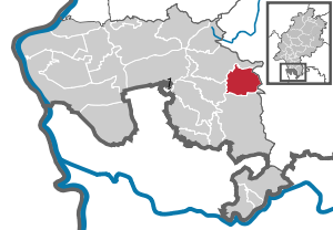
| Location of the community Grasellenbach in the Bergstrasse district | ||
  |
||

Grasellenbach is a municipality in the Bergstrasse district in southern Hesse with around 4,000 inhabitants. It is known nationwide as the location of a Siegfried Fountain . The administrative headquarters are located in the largest district of Hammelbach .
geography
location
The Odenwald community is located in the UNESCO Geopark Bergstrasse-Odenwald at an altitude of between 420 and 580 m above sea level. NN . The districts of Grasellenbach are traversed by the two most important brooks of the southern Odenwald, the Ulfenbach and the Weschnitz , which arise in the Hammelbach district, where the watershed between the Neckar and the Rhine runs.
Neighboring communities
Grasellenbach borders in the north on the municipality of Fürth , in the east on the municipality of Mossautal , which belongs to the Odenwaldkreis , in the south on the municipality of Wald-Michelbach and in the west on the municipality of Rimbach .
Districts


- Gras-Ellenbach
- elections
- Hammelbach
- Litzelbach
- Scharbach , consisting of the districts of Ober-Scharbach and Unter-Scharbach
- Tromm in the district of Ober-Scharbach
Hammelbach
Today's climatic health resort Hammelbach is the largest and oldest district and the administrative seat of the entire community of Grasellenbach, with around 1400 inhabitants. Hammelbach means something like "creek on a steep hill". This naming comes from the fact that the two most important brooks arise in Hammelbach: the Ulfenbach and the Weschnitz. Both the Protestant and the Catholic Church are located in Hammelbach. There is also an outdoor pool in Hammelbach, which is fed from spring water, and a campsite. The Hammelbacher Kirchweihfest , called Kerwe here, is celebrated every year on the last weekend of September and has its origins in the consecration of the Protestant Reformed church built in 1802. Historically, Hammelbach is the only legitimate district that is allowed to host the parish fair, as the Protestant church is also located in it. In the Middle Ages, Hammelbach was the center of the Hammelbacher or Aicher Cent . The Gothic chapel ruins from the 14th century in the cemetery and the historic bakery are well worth seeing. Every year in March the so-called black powder rally takes place. Numerous motorcyclists from all over Germany always come to Hammelbach for this event.
Gras-Ellenbach
The Kneipp therapeutic bath Gras-Ellenbach is the second largest district of the municipality with almost 1000 inhabitants. Gras-Ellenbach is known for a spring on the Spessartskopf, where Siegfried von Hagen was allegedly killed. This is one of the reasons why the district of Gras-Ellenbach is the district of the large community that is most frequented by spa guests.
Grass-Ellenbach is at 450- 550 m height. The meadows through which the Ulfenbach flows here are said to have given the place its name. The added ellen may be derived from Elm (elm). There are other attempts at interpretation, but these are controversial.
Gras-Ellenbach is a state-approved climatic health resort with a Kneipp spa. Odenwald plays have been performed on the home stage in the Nibelungenhalle for over two decades.
Further districts
With about 100 inhabitants, Tromm is the smallest and, at 539 m, the highest district of the municipality. It is located on the northeast slope of the Tromm in the middle of meadows and forests and presents itself as a recreation and conference location with hiking trails and winter sports facilities.
The three other districts of Wahlen (around 900 inhabitants), Scharbach (around 470 inhabitants) and Litzelbach (around 150 inhabitants) are primarily recreational areas.
history
The municipality Grasellenbach was created in its current form on December 31, 1971 through the voluntary amalgamation of the previously independent municipalities Hammelbach, Gras-Ellenbach and Wahlen. On August 1, 1972, Grasellenbach expanded through the legally mandated incorporation of the communities of Litzelbach and Scharbach.
The districts combined in this way had already been combined in the Palatinate “Aicher Cent” in the Middle Ages up to the beginning of the 19th century . Only Litzelbach belonged to the Kurmainzischen Cent Abtsteinach . The Cent - an administrative facility similar to a present-day municipality - was named Aicher or Hammelbacher Cent after the location of the court on the "Gefehlten Aiche". The Hammelbach district was first mentioned in 795, while the other districts were first mentioned around 1300. The affiliation of the places to the Electoral Palatinate or Kurmainz lasted until 1802. After that, the communities came to the Grand Duchy of Hesse through the Reichsdeputationshauptschluss .
The original craft and farming villages experienced a boom in the 19th century when the red sandstone processing flourished. In the 20th century tourism grew in importance, so that tourism became an important branch of the economy, especially in the district of Gras-Ellenbach.
Church building
The municipality of Grasellenbach was created on December 31, 1971 through the merger of the municipalities of Gras-Ellenbach, Hammelbach and Wahlen, which took place in the run-up to the regional reform in Hesse . At the end of this, the municipalities Litzelbach and Scharbach were incorporated on August 1, 1972 by the law on the reorganization of the Bergstrasse district. Local districts were not formed in the municipality.
population
Population structure
According to the 2011 census , there were 3,802 residents in Grasellenbach on May 9, 2011. Among them were 337 (8.9%) foreigners, of whom 135 came from outside the EU , 188 from other European countries and 14 from other countries. The inhabitants lived in 1539 households. Of these, 448 were single households , 479 couples without children and 458 couples with children, as well as 128 single parents and 26 shared apartments . 1703 inhabitants belonged to the Protestant (44.8%) and 1,087 inhabitants of the Catholic (28.6%) denomination.
Population development
| Grasellenbach: Population from 1970 to 2015 | ||||
|---|---|---|---|---|
| year | Residents | |||
| 1970 | 2,905 | |||
| 1976 | 2,958 | |||
| 1984 | 2,969 | |||
| 1992 | 3,632 | |||
| 2000 | 3,900 | |||
| 2005 | 3,954 | |||
| 2010 | 3.714 | |||
| 2011 | 3,802 | |||
| 2015 | 3,881 | |||
| Sources: see the following list | ||||
- In 1970 the communities united in the community Grasellenbach had 3598 inhabitants.
- In the local elections in 1977, as of June 1976, 3777 inhabitants were taken as the basis.
- In the local elections in 1985, as of June 30, 1984, 3910 inhabitants were assumed.
- In the local elections in 1993, as of March 31, 1992, 4151 inhabitants were assumed.
- The Hessian community encyclopedia names for the year 2000: 4200 inhabitants.
- According to the Hessian State Statistical Office, 4117 inhabitants lived in the Fischbachtal on June 30, 2005.
- The Hessian State Statistical Office reported for June 30, 2010: 3990 inhabitants.
- The 2011 census counted 4056 inhabitants.
- As of June 30, 2015, the Hessian State Statistical Office reports 4151 inhabitants.
Gainful employment
The municipality in comparison with the district, administrative district Darmstadt and Hesse:
| year | local community | district | Administrative district | Hesse | |
|---|---|---|---|---|---|
| Employees subject to social security contributions | 2018 | 796 | 75.286 | 1,740,388 | 2,584,005 |
| Change to | 2000 | −7.8% | + 20.9% | + 19.2% | + 18.8% |
| of which full-time | 2018 | 69.7% | 70.6% | 72.6% | 71.5% |
| of which part-time | 2018 | 30.3% | 29.4% | 27.4% | 28.5% |
| Only marginally paid employees | 2018 | 174 | 15,568 | 222,301 | 369,892 |
| Change to | 2000 | −23.7% | −4.6% | + 8.1% | + 7.9% |
| Branch | year | local community | district | Administrative district | Hesse |
|---|---|---|---|---|---|
| Manufacturing | 2000 | 44.1% | 39.6% | 27.0% | 30.6% |
| 2018 | 27.9% | 32.0% | 20.4% | 24.3% | |
| Commerce, hospitality and transport | 2000 | 21.6% | 25.1% | 26.4% | 25.1% |
| 2018 | 22.1% | 25.8% | 24.7% | 23.8% | |
| Business services | 2000 | *) | 11.6% | 25.1% | 20.2% |
| 2018 | 8.9% | 15.3% | 31.7% | 26.2% | |
| other services | 2000 | 31.3% | 22.0% | 20.1% | 22.5% |
| 2018 | 40.7% | 25.1% | 22.8% | 25.2% | |
| Other (or without assignment) | 2000 | 3.0% | 1.7% | 1.4% | 1.5% |
| 2018 | 0.4% | 1.1% | 0.3% | 0.4% |
*) anonymized
politics
Community representation
The local elections on March 6, 2016 produced the following results, compared to previous local elections:
| Parties and constituencies |
% 2016 |
Seats 2016 |
% 2011 |
Seats 2011 |
% 2006 |
Seats 2006 |
% 2001 |
Seats 2001 |
|
| Social Democratic Party of Germany | 28.9 | 6th | 30.6 | 7th | 33.1 | 7th | 34.2 | 8th | |
| Christian Democratic Union of Germany | 28.8 | 5 | 30.0 | 7th | 33.2 | 8th | 29.7 | 7th | |
| Free non-party voter group Grasellenbach | 32.9 | 6th | 25.2 | 6th | 25.2 | 6th | 28.6 | 6th | |
| Alliance 90 / The Greens | 9.4 | 2 | 14.1 | 3 | 8.6 | 2 | 7.6 | 2 | |
| total | 100.0 | 19th | 100.0 | 23 | 100.0 | 23 | 100.0 | 23 | |
| Voter turnout in% | 49.8 | 51.9 | 53.2 | 59.5 | |||||

mayor
Markus Röth has been mayor of Grasellenbach since 1997 .
Partnerships
Grasellenbach has had partnerships with Bédarrides in France and Cunit in Spain since 1983 .
badges and flags

coat of arms
Blazon : “Shield of black, gold and red diagonally square. Field 1 shows the upright golden Palatinate lion (turned to the right, crowned, tamed and reinforced), fields 2 and 3 each have a red linden leaf and field 4 in red two silver wavy bars. "
The coat of arms of the Grasellenbach community was approved by the Hessian Interior Minister on September 6, 1974 . It was designed by the Bad Nauheim heraldist Heinz Ritt .
It is made up of elements from the historical coats of arms of Gras-Ellenbach and Hammelbach. The Palatinate Lion is a reminder of the former belonging to the Electoral Palatinate, the colors red and silver of Hesse. The wave beams represent the abundance of water in Grasellenbach and the linden leaves point to the Nibelungen saga .
flag
The flag was approved by the Hessian Ministry of the Interior on May 18, 1978 and is described as follows:
Flag description: "The municipal coat of arms is placed on white flag cloth with red stripes in the upper third."
Economy and Infrastructure
Land use
The municipality covers a total area of 2288 hectares, of which in hectares are:
| Type of use | 2011 | 2015 | |
|---|---|---|---|
| Building and open space | 146 | 148 | |
| from that | Living | 88 | 89 |
| Business | 12 | 13 | |
| Operating area | 3 | 4th | |
| from that | Mining land | 3 | 3 |
| Recreation area | 13 | 13 | |
| from that | Green area | 6th | 6th |
| traffic area | 78 | 78 | |
| Agricultural area | 831 | 829 | |
| from that | moor | 0 | 0 |
| pagan | 0 | 0 | |
| Forest area | 1206 | 1206 | |
| Water surface | 3 | 3 | |
| Other use | 7th | 7th | |
tourism
Grasellenbach owes around 66,000 overnight stays annually in 2018 to its properties as a Kneipp spa and climatic health resort as well as the operation of the conference facilities. That is 8.3 percent of the overnight stays in the Bergstrasse district. The community lives mainly from tourism .
The influx of visitors is also promoted by the fact that one of the Siegfriedsbrunnen is located in Grasellenbach , of which it is alleged that Siegfried von Hagen von Tronje was murdered on them , as described in the Nibelungenlied . This makes Grasellenbach a station on Siegfriedstrasse . Grasellenbach has also joined the network of the so-called Nibelungen cities. The 130-kilometer long- distance hiking trail Nibelungensteig , certified with the quality seal “Quality Trail Hikable Germany”, runs through the district of Gras-Ellenbach and past the Siegfriedbrunnen, and runs through the Odenwald from west to east. Grasellenbach is also a member of the Bergstrasse-Odenwald Geo-Nature Park.
traffic
The community is connected to the federal motorway 5 via the B 460 .
Regular buses run to the train stations in Heppenheim and Weinheim , which, like Grasellenbach, belong to the Rhein-Neckar transport association. Tickets of the Rhein-Main-Verkehrsverbund as well as the Hessenticket are also recognized.
Between 1901 and 1983 the Wahlen district was the end point of the Überwaldbahn .
literature
- Hans-Günther Morr: Legends, fairy tales, stories from the Überwald with historical hallway paintings . Geiger-Verlag, Horb am Neckar, 1991. ISBN 3-89264-580-9
- Peter W. Sattler and Markus Röth: Grasellenbach. Nature-culture-history . Geiger-Verlag, Horb am Neckar, 1993.
- Peter W. Sattler and Dietmar Lehmann: Our home - the Überwald . Wald-Michelbach community, Wald-Michelbach, 1984. ISBN 3-9800971-0-2
- Hans Schmitt: Hammelbach high in the Odenwald . Municipal administration Hammelbach, Hammelbach 1969.
- Hans-Jürgen Speichert: Gras-Ellenbach, Hammelbach, Litzelbach, Scharbach, elections. The development of selected tourist locations in the Odenwald . (Heidelberg geographical works, 55). Geographical Institute of Heidelberg University, Heidelberg 1979. ISBN 3-88570-055-7
- Literature on Grasellenbach in the Hessian Bibliography
- Literature by and about Grasellenbach in the catalog of the German National Library
Web links
- Grasellenbach (municipality), Bergstrasse district. Historical local dictionary for Hessen. In: Landesgeschichtliches Informationssystem Hessen (LAGIS).
- Information on the community of Grasellenbach. In: Hessisches Gemeindelexikon. HA Hessen Agentur GmbH , 2016.
- Gras-Ellenbach, Bergstrasse district. Historical local dictionary for Hessen. In: Landesgeschichtliches Informationssystem Hessen (LAGIS).
Individual evidence
- ↑ Hessian State Statistical Office: Population status on December 31, 2019 (districts and urban districts as well as municipalities, population figures based on the 2011 census) ( help ).
- ^ Federal Statistical Office (ed.): Historical municipality directory for the Federal Republic of Germany. Name, border and key number changes in municipalities, counties and administrative districts from May 27, 1970 to December 31, 1982 . W. Kohlhammer GmbH, Stuttgart / Mainz 1983, ISBN 3-17-003263-1 , p. 349 and 350 .
- ↑ Law on the reorganization of the Bergstrasse district (GVBl. II 330–15 § 6) of July 11, 1972 . In: The Hessian Minister of the Interior (ed.): Law and Ordinance Gazette for the State of Hesse . 1972 No. 17 , p. 222 ff . ( Online at the information system of the Hessian State Parliament [PDF; 1,2 MB ]).
- ↑ a b Population by nationality groups: Grasellenbach. In: Zensus2011. Bavarian State Office for Statistics , accessed in July 2015 .
- ^ Households by family: Grasellenbach. In: Zensus2011. Bavarian State Office for Statistics , accessed in July 2015 .
- ↑ Religion: Grasellenbach. In: Zensus2011. Bavarian State Office for Statistics , accessed in July 2015 .
- ↑ Grasellenbach (municipality), Bergstrasse district. Historical local dictionary for Hessen. (As of June 1, 2018). In: Landesgeschichtliches Informationssystem Hessen (LAGIS).
- ↑ Local elections 1977; Relevant population figures for the municipalities as of December 15, 1976 . In: The Hessian Minister of the Interior (ed.): State Gazette for the State of Hesse. 1976 No. 52 , p. 2283 , point 1668 ( online at the information system of the Hessian state parliament [PDF; 10.3 MB ]).
- ^ Local elections 1985; Relevant population of the municipalities as of October 30, 1984 . In: The Hessian Minister of the Interior (ed.): State Gazette for the State of Hesse. 1984 No. 46 , p. 2175 , point 1104 ( online at the information system of the Hessian state parliament [PDF; 5.5 MB ]).
- ↑ local elections 1993; Relevant population of the municipalities as of October 21, 1992 . In: The Hessian Minister of the Interior (ed.): State Gazette for the State of Hesse. 1992 No. 44 , p. 2766 , point 935 ( online at the information system of the Hessian state parliament [PDF; 6.1 MB ]).
- ↑ a b community data sheet: Grasellenbach. (PDF; 222 kB) In: Hessisches Gemeindelexikon. HA Hessen Agency GmbH
- ^ The population of the Hessian communities (June 30, 2005). In: Hessian State Statistical Office . Archived from the original .
- ^ The population of the Hessian communities (June 30, 2010). In: Hessian State Statistical Office . Archived from the original .
- ^ The population of the Hessian communities (June 30, 2015). In: Hessian State Statistical Office . Archived from the original .
- ^ Result of the municipal election on March 6, 2016. 431009 Grasellenbach. Hessian State Statistical Office, accessed in April 2016 .
- ^ Result of the municipal election of March 27, 2011. 431009 Grasellenbach. Hessian State Statistical Office, accessed in January 2020 .
- ^ Result of the municipal election of March 26, 2006. 431009 Grasellenbach. Hessian State Statistical Office, accessed in January 2020 .
- ↑ Results of the municipal elections of 2001 and 1997. (No longer available online.) Hessian State Statistical Office, archived from the original ; accessed in December 2019 .
- ↑ Mayoral elections in Grasellenbach. Hessian State Statistical Office , accessed in January 2020 .
- ↑ Approval of a coat of arms of the community Grasellenbach, district Bergstrasse from September 6, 1974 . In: The Hessian Minister of the Interior (ed.): State Gazette for the State of Hesse. 1974 No. 39 , p. 1735 , point 1240 ( online at the information system of the Hessian state parliament [PDF; 5.3 MB ]).
- ↑ Approval of a flag of the community Grasellenbach Landkreis Bergstrasse from May 18, 1978 . In: The Hessian Minister of the Interior (ed.): State Gazette for the State of Hesse. 1978 No. 23 , p. 1059 , point 659 ( online at the information system of the Hessian state parliament [PDF; 8.7 MB ]).
- ↑ Hessisches Statistisches Informationssystem In: Statistics.Hessen.
- ↑ Guests and overnight stays in Hessian tourism. Hessian State Statistical Office, accessed in January 2020 .

Abtsteinach | Bensheim | Biblis | Birkenau | Bürstadt | Einhausen | Fürth | Gorxheimertal | Grasellenbach | Gross-Rohrheim | Heppenheim (Bergstrasse) | Hirschhorn (Neckar) | Lampertheim | Lautertal (Odenwald) | Lindenfels | Lorsch | Mörlenbach | Neckarsteinach | Rimbach | Viernheim | Wald-Michelbach | Zwingenberg
Non- parish area in the Bergstrasse
Michelbuch district
Gras-Ellenbach | Hammelbach | Litzelbach | Elections | Scharbach from Unter-Scharbach and Ober-Scharbach with the Tromm residential area