
Freienstein Castle
| Freienstein Castle | ||
|---|---|---|
 Freienstein ruins |
||
| Alternative name (s): | Freienstein Castle | |
| Creation time : | before 1297 | |
| Castle type : | Höhenburg, spur location | |
| Conservation status: | ruin | |
| Place: | Gammelsbach | |
| Geographical location | 49 ° 31 '40.1 " N , 8 ° 57' 47.2" E | |
| Height: | 328 m above sea level NN | |
|
||

The castle Freienstein is the ruin of a Spur castle in Beerfelden high above Gammelsbach , a district of Oberzent in Odenwaldkreis in Hesse . The Freienstein office is named after the castle .
location
The castle was in the spur position at 328 m above sea level. NN above the Gammelsbach , a tributary of the Neckar , in a strategically favorable position. One of the most important regional transport links still runs through the valley, which is quite narrow at this point, with the B 45 . Freienstein Castle once controlled this route between the Neckar region in the south and the Main Valley in the north. At the same time, it marked the southernmost point of the Erbach property. The eastern ledge on which the castle stands belongs to the Weckberg , which stands in the row of elevations of the Hirschhorner Höhe ridge , which extends between Gammelsbachtal and the parallel Finkenbachtal further west approximately from north to south.
history
middle Ages
The "Freienstein Castle" was first mentioned in 1297. It is still not clear who built the castle. It is likely to have arisen in the wake of the dissolution of the imperial abbey of Lorsch Monastery and the division of its property in the triangle of power relations between the Count Palatine , the Erbach and Kurmainz taverns .


Some of the remaining building fabric also points to this time. Two preserved, but bricked-up Gothic pointed arch windows are believed to date from the second half of the 13th century. Furthermore, it can be reconstructed that in an early construction phase, instead of the later shield wall, there must have been a mighty residential tower, which is to be understood as a donjon .
The lords of Freienstein have been documented since 1280, and later they are recorded as Erbacher Burgmannen in the castle. Furthermore, the real ones , those of Schöllenbach and possibly those of Hochhausenn can be accessed, which were more frequently to be found as ministerials in the area around the county of Erbach .
Documented is known that in 1366 Count Palatine Ruprecht I gave his consent that Schenk Konrad von Erbach his wife Margarete bewittumte . The castle's accessories at that time included Gammelsbach , Hebstahl , Schöllenbach , Hohenberge , Beerfelden , Etzean , Erlenbach , Hüttental and Hiltersklingen . Twenty-two years later, Count Palatine Ruprecht gave his consent that Schenk Eberhard von Erbach allowed his wife Else, née von Kronberg , to use accessories on 1/4 of the "Feste Freienstein". Only one more year later, Schenk Konrad von Erbach was allowed to pledge his quarter of the castle to "Contz von Helmstadt" with the approval of the Count Palatine . In 1398 the Count Palatine Schenk enfeoffed Eberhard von Erbach with the entire castle and its accessories. Enfeoffment of the Erbacher by the count palatine took place again in 1443, 1653 and 1720.
Later, the castle served the Erbach counts to secure their southern border, to monitor traffic in the Gammelsbachtal and as the administrative seat of the Freienstein office. The castle remained until the extinction of Erbacher line of Taverns in 1503 in the undivided ownership, while the surrounding centering Beerfelden there was jointly owned by the Erbacher line and the line Reichenberg-Fuerstenau.
Modern times
At the end of the Middle Ages, the castle had become unsuitable for military purposes. A renovation followed around 1550, and the compact residential buildings erected at that time show the rather representative character of the complex. The Erbach counts used the castle for occasional hunting trips and as a secondary residence. From the time of the Thirty Years' War , the facility began to deteriorate more and more because it was only poorly maintained. Nevertheless, it was sacked by Bavarian cavalry in May 1622. A view by Eberhard Kieser in the Thesaurus Philopoliticus from 1629 shows them still in a somewhat intact condition. From 1700 the castle was no longer permanently inhabited. With the Erbacher inheritance in 1717 she came into the possession of the Erbach-Fürstenau line, which she still owns today.
After the town fire in Beerfelden in 1810, Count Albert zu Erbach-Fürstenau allowed the injured party to get stones, bricks and timber from the castle. Not only was part of the building fabric lost as a result, but the remaining substance has since been permanently damaged by the water penetrating the unprotected sandstone masonry. In 1887 what was left of the gatehouse collapsed. Around 1890 the shield wall was secured with a tie rod and removed by three meters in 1938. Further security measures took place between 1906 and 1914. In 1987 part of the shield wall collapsed. In 1988 they began to secure, but the wall continued to collapse during the work, tearing the scaffolding that had already been erected with it. From 1990 to 1994 the outer walls were extensively restored.
Due to its history and architecture, the castle has a variety of meanings and is the defining landmark of the Gammelsbach valley. In order to maintain the long-distance effect of the castle and the surrounding landscape, it and the surrounding parcels form the listed material entity Schlossberg, which in corridor 8 includes parcels 65 to 68, 70 to 91 (including parcels 80 and 81 as the location of the castle), 94 , 110/4/10/11 and 111 encloses.
investment

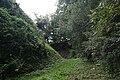
In addition to its dominant location, which blocks the Gammelsbachtal, the compact development of the core castle and the remains of the shield wall are particularly striking about Freienstein Castle . This was supposed to protect the core castle from fire from the higher mountain. Although large parts of it collapsed, remains of it up to 24 m high and 2.50 m thick can still be seen. The view by Eberhard Kieser from 1629 shows that a defensive platform on the shield wall was supposed to serve the purpose that the keep and the highest tower otherwise served.
The shield wall was probably built after a collapse from the remains of the former donjon , including the three outer walls. The earlier shape of the main castle was unusual, namely there were three residential towers - the one mentioned on the shield wall, the smaller chapel building and a previous building of the palace . Apparently, this was intended to create separate living space for the various Burgmann families.
The mountain spur was separated from the ridge in the west by a deep ditch and a kennel . On the valley side there was a double kennel with half-shell towers , a larger round tower probably served as a dungeon. The access was on the north side and can no longer be seen today, as the gate system collapsed in 1887. In the gate area of the Zwinger there were a few outbuildings, but nothing has survived.
To the left of the former entrance is the tower-like hall on an almost square floor plan. Parts from the 13th century are still preserved in the masonry. Of the main castle buildings - the Palas, the former four-story hall building on the southwest side (probably on the site of an earlier residential tower) and the southeast building, also known as the chapel - only the outer walls, windows and wall niches, most of them from the 16th century, have survived come.

Exterior view of the inner castle from the east

Exterior view of the inner castle from the south, left remains of the shield wall

The valley wall with a half-shell tower
Look into the neck ditch

Interior view of the main castle, view from the north, on the right the shield wall


literature
- Alexander Antonow: Castles of southwest Germany in the 13th and 14th centuries - with special consideration of the shield wall . Konkordia publishing house, Bühl / Baden 1977, ISBN 3-7826-0040-1 , pp. 149-151.
- Thomas Biller: Castles and palaces in the Odenwald. A guide to history and architecture. Schnell and Steiner, Regensburg 2005, ISBN 3-7954-1711-2 , pp. 117-120.
- Rudolf Knappe: Medieval castles in Hesse - 800 castles, castle ruins and castle sites . 3rd edition, Wartberg-Verlag, Gudensberg-Gleichen 2000, ISBN 3-86134-228-6 , p. 549.
- Thomas Steinmetz: Castle Freienstein and their castle men. In: Contributions to the exploration of the Odenwald and its peripheral landscapes VI. Published on behalf of the Breuberg Association by Winfried Wackerfuß, Breuberg-Neustadt 1997, ISBN 3-922903-06-1 , pp. 47–81.
- Thomas Steinmetz: Castles in the Odenwald. Verlag Ellen Schmid, Brensbach 1998, ISBN 3-931529-02-9 , p. 82f.
- Hans Teubner and Sonja Bonin: Cultural monuments in Hesse. Odenwaldkreis. Published by the State Office for Monument Preservation Hessen , Vieweg, Braunschweig / Wiesbaden 1998 ( Monument Topography Federal Republic of Germany ), ISBN 3-528-06242-8 , pp. 141f.
- Rolf Müller (Ed.): Palaces, castles, old walls. Published by the Hessendienst der Staatskanzlei, Wiesbaden 1990, ISBN 3-89214-017-0 , pp. 42–44.
- State Office for Monument Preservation Hessen (Ed.): Monument topography of the Federal Republic of Germany. Cultural monuments in Hessen. Odenwaldkreis. Wiesbaden 1998, pp. 140-142.
Individual evidence
- ↑ Thomas Biller: Castles and palaces in the Odenwald. A guide to history and architecture. Schnell and Steiner, Regensburg 2005, p. 117.
- ↑ A copy of the document from the 15th century is preserved in the Hessian State Archives in Marburg under the Katzenelnbogischen documents. Regest with Karl E. Demandt: Regest of the Counts of Katzenelnbogen. Wiesbaden 1953-57 No. 393.
- ↑ Thomas Steinmetz: Castle Freienstein and their Burgmannen. Breuberg-Neustadt 1997, pp. 70f.
- ↑ Thomas Steinmetz: Castle Freienstein and their Burgmannen. Breuberg-Neustadt 1997, pp. 64-66 and 68-71; same: castles in the Odenwald. Brensbach 1998, p. 83.
- ↑ Burg Freienstein, Odenwaldkreis (section: Land Lordship and Landowner :). Historical local lexicon for Hesse (as of July 9, 2014). In: Landesgeschichtliches Informationssystem Hessen (LAGIS). Hessian State Office for Historical Cultural Studies (HLGL), accessed on February 1, 2016 .
- ↑ Thomas Steinmetz: Castles in the Odenwald. Brensbach 1998, p. 175.
- ↑ Monument topography Odenwaldkreis 1998, p. 142.
- ↑ Thomas Steinmetz: Castles in the Odenwald. Brensbach 1998, p. 83.
Web links
- Freienstein Castle, Odenwaldkreis. Historical local dictionary for Hessen. In: Landesgeschichtliches Informationssystem Hessen (LAGIS).
- View of the Freienstein castle ruins from the southeast, around 1900. Historical views of the town, plans and floor plans. In: Landesgeschichtliches Informationssystem Hessen (LAGIS).
- State Office for Monument Preservation Hessen (Hrsg.): Burg Freienstein In: DenkXweb, online edition of cultural monuments in Hessen
- Castle ruin "Freienstein" on the side of the city of Beerfelden
- Historical reconstruction drawing by Wolfgang Braun

Beerfurther Schlösschen | Breuberg Castle | Jagdschlösschen Carlsruhe | Erbach Castle | Eulbach Hunting Lodge | Freienstein Castle | Fürstenau Castle | Gammelsbach Hunting Lodge | Burgstall Güttersbach | Kirchbrombach Castle | Bad König Castle | Jagdschloss Krähberg | Lützelbach Castle | Michelstadt Castle | Mühlhäuser Schlößchen | Reichenberg Castle | Rodenstein Castle | Schnellerts Castle | Stutz Castle


Amorbach Palace | Alsbach Castle | Old castle | Old castle | Auerbach Castle | Bacheburg | Bad König Castle | Beerfurther Schlösschen | Birkenau Castle | Palais Boisserée | Breuberg Castle | Ringwall Bürgstadter Berg | Burgschell | Jagdschlösschen Carlsruhe | Curti lock | Dallau Castle | Darmstadt Castle (Groß-Umstadt) | Dauchstein Castle | Mountain fortress Dilsberg | Dorndiel Castle | Emichsburg | Eberbach Castle | Erbach Castle | Erdwerk Ohrbacher Schanze | Ernsthofen Castle | Eulbach Hunting Lodge | Fechenbach Castle | Frankenberg Castle (Amorbach) | Frankenstein Castle | Freienstein Castle | Freudenberg Castle | Fürstenau Castle | State Park Princely Camp | Fürstenstein Castle | Gammelsbach Hunting Lodge | Ringwall Greinberg | Burgstall Güttersbach | Guttenberg Castle | Grand Ducal Palace (Heidelberg) | Hammer lock | Hardheim Castle | Harfenburg | House to the Giant | Heddersdorf'scher Adelshof | Heidelberg Castle | Heiligenberg Castle | Heppenheim City Palace | Hinterburg | Hirschburg | Hirschhorn Castle | Hochhausen Castle | Hornberg Castle | Hundheim Castle | Jossa Castle | Kirchbrombach Castle | Jagdschloss Krähberg | Kronenburg | Kurmainzer Amtshof | Landsehr Castle | Lichtenberg Castle | Limbach Castle | Lindenfels Castle | Lohrbach Castle | Löwenstein Castle | Lützelbach Castle | Wall hexagon | Max-Wilhelmshöhe hunting lodge | Michelstadt Castle | Mildenburg | Minneburg | Mittelburg | Burgstall Mörlenbach | Palais Morass | Mühlhäuser Schlößchen | Neuburg Castle (Baden) | Nieder-Modau Castle | Upper Heidelberg Castle | Obrigheim Castle | Ohrsberg Castle | Veste Otzberg | Palatinate Castle | Reichenberg Castle | Reichenstein Castle | Riedern moated castle | Rodenstein Castle | Rodenstein Castle | Rohrbach Castle | Rohrbach Castle | Schaafheim Castle | Schanzenköpfle | Schauenburg | Schlierbach Castle | Castle Ober-Beerbach | Schloss-Naus castle | Schneirersbuckel tower hill | Schnellerts Castle | Schönberg Palace | Swallow's Nest | Schwarzach moated castle | Schweinberg Castle | Starkenburg | Stolzeneck Castle | Strahlenburg | Stutz Castle | Amorbach Templar House | Tannenberg Castle | Lower Hardheim Castle | Vorderburg | Wachenburg | Burgstall Waldau | Waldeck Castle | Waldleiningen Castle | Wald-Michelbach Castle | Wambolt's Castle | Hamlet hill | Weinheim Castle | Wiser Castle | Wildenberg Castle | Windeck Castle | Wörth Castle (Wörth am Main) | Zwingenberg Castle