Kronenburg (Dossenheim)
| Kronenburg | ||
|---|---|---|
| Alternative name (s): | Old lock | |
| Castle type : | Hilltop castle | |
| Conservation status: | Remnants of walls, ditches, ramparts | |
| Place: | Dossenheim | |
| Geographical location | 49 ° 27 '10.8 " N , 8 ° 41' 45.6" E | |
| Height: | 303.7 m above sea level NN | |
|
|
||
The castle stables of a multiple castle near Dossenheim in the Rhein-Neckar district in the north-west of Baden-Württemberg are called Kronenburg (actually, correctly, Altes Schlössel ) .
location
The remains of the hill fort are about 300 meters above sea level on a spur in the Odenwald , which divides the Dossenheimer Mühltal in the west and is surrounded by two spring streams to the north and south. In the valley south there is an old path into the Neckar and Steinach valleys . Not far away in the north-west is the Schauenburg , further remains of the wall (so-called wall hexagon ) are to be found to the south-west in the Gewann "in Wolfsgrund".
history
The group of castles has not yet been classified historically. Assumptions that these were predecessor buildings of the Schauenburg could not be proven. There are no documented mentions. The building findings suggest the 11th or early 12th century. The name Kronenburg comes from an incorrect assignment from the 19th century. The traditional name is Altes Schlössel (not to be confused with the former castle in Dossenheim's old town).
investment
Only sparse remains of the structures have survived. The artificial formation of today's tree-covered area is clearly evident.
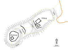
The east castle is separated from the saddle by two ramparts. In the north and west it is surrounded by a small wall, which probably continued to the south until a forest road was built. From the ramparts only loose rubble walls are present. On the polygonal plateau with a length of 60 meters and a width of 45 meters, the ground plans of a round building, a building disrupted by search excavations and a pit appear in the west.
The western castle is about 30 meters to the west. With the exception of the steeply sloping north side, it is surrounded by a ring moat.
The two castles on the polygonal plateau each have a diameter of 40 meters. In the 1930s, the foundations of the curtain walls were exposed. The foundations of a building emerged from it. Remnants of the wall found between the two castles are interpreted as the outer bailey.
At a distance of 270 m east-northeast of the eastern neck ditch of the east castle of Kronenburg are the remains of a hill ( location ), which is interpreted as a siege hill . It is approx. 30 m × 30 m in external dimensions and is protected on the mountain side by a neck ditch, a ring wall and an additional ring ditch. The hill is in the lower range of a typical Blidenschanze . A recent mountain bike trail running through her bothered her badly.
literature
- Thomas Biller: Castles and palaces in the Odenwald: A guide to history and architecture . Regensburg 2005, ISBN 3-7954-1711-2 , pp. 95f.
- Christian Burkhart: A high medieval air heater from the old castle (so-called “Kronenburg”) near Dossenheim on the Baden Bergstrasse. In: The Odenwald. Zeitschrift des Breuberg-Bundes, No. 4, 2006, pp. 148–161.
- Achim Wendt: The riddle of the "Kronenburg (en)": an inventory from an archaeological point of view . In: Heimatverein Dossenheim, reports, information, communications, No. 17, 1997 . 1998
- Rainer Kunze: Subject: »Kronenburg« and Schauenburg near Dossenheim . In: Mannheimer Geschichtsblätter New Series Vol. 3/1996 . Sigmaringen 1996, ISBN 3-7995-0957-7
- Rainer Kunze: Chapel or chicken coop? - Kronenburg again . In: Mannheimer Geschichtsblätter New Series, Vol. 6/1999 . Ubstadt-Weiher 1999, ISBN 3-89735-129-3
- Thomas Steinmetz: Castles in the Odenwald. Verlag Ellen Schmid, Brensbach 1998, ISBN 3-931529-02-9 , p. 34f.
- State Archive administration Baden-Württemberg in connection with d. Cities and districts Heidelberg u. Mannheim (Hrsg.): The city and districts Heidelberg and Mannheim: Official district description .
- Vol. 2: The city of Heidelberg and the municipalities of the district of Heidelberg . Karlsruhe 1968
Web links
- Area map of Kronenburg on: State Agency for the Environment Baden-Württemberg (LUBW) ( information )
Individual evidence
- ↑ Christian Burkhart: Discovery, research and preservation of the so-called "wall hexagon" in Wolfsgrund near Dossenheim on Bergstrasse. In: The Odenwald. Zeitschrift des Breuberg-Bundes 43/1, 1996, pp. 3-19.
- ↑ Thomas Steinmetz: Castles in the Odenwald. Verlag Ellen Schmid, Brensbach 1998, ISBN 3-931529-02-9 , p. 29f.
- ↑ B. Schröder, Th. Steinmetz: The facilities of the "Kronenburg" near Dossenheim on Bergstrasse . In: Burgen und Schlösser, 1983, Volume 11, pp. 87 ff.
- ↑ Biker destroy old hill , Mannheimer Morgen, edition of June 11, 2012, accessed on June 16, 2015.


