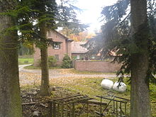
Max-Wilhelmshöhe hunting lodge

The former hunting lodge Max-Wilhelmshöhe (also called Jagdschloss Wilhelmshöhe or Jagdschloss Waldbrunn ) is located in the northern part of Waldbrunn in the Neckar-Odenwald district in northern Baden-Württemberg near the state border with Hesse in the Odenwald and the catchment area of the Neckar .
location
The simple property is located in the northern part of the Mülben district , at the northern end of a clearing in the middle of a large forest area at 509 m above sea level. NHN lies above the Unterhöllgrund , which the Reisenbach flows around in a northern semicircle from east to west and flows into the Itter about 1.5 kilometers southwest . There is only one forest road to today's forester's house. The place can also be reached from the village of Reisenbach and its hamlet Reisenbacher Grund , which are closer to the property, although they belong to the neighboring municipality of Mudau . The plateau area, on the north-western edge of which is the former hunting lodge, is known as the winter breath and extends to the fourth highest peak of the Odenwald, the Markgrafenwald .
Geography and geology
Several hiking trails cross the scenic square, which is part of the Neckartal-Odenwald Nature Park and the Bergstrasse-Odenwald Geo-Nature Park . Not far from the location is the volcanic vent of the Katzenbuckels , the highest mountain in the Odenwald. Only a few kilometers to the north are the ruins of the forts of the old Limes line of the Neckar-Odenwald-Limes , such as the Seitzenbuche small fort . The entire plateau around the former hunting lodge belongs geologically to the Middle Buntsandstein and is geographically in the rear Odenwald . The sandstone was quarried in the area as Neckar valley sandstone .
history
The grounds of the hunting lodge were laid out around 1850. It probably later belonged to Prince Max von Baden , who owned the surrounding hunting area.
description
The hunting lodge consists of a property, partially enclosed by a brick wall, with the manor house , a forester's house and various farm buildings .
The manor house of the hunting lodge is a two-storey sandstone building with a three-row central projection facing south (front side) in the direction of the clearing, which is extended in one row on both sides and has a saddle roof . It is marked in the gable with the year 1844. The eaves are tied in a staircase . Among them is above the middle window on the second floor in size that of a narrow portal protected Baden coat of arms of the Marquis of Zwingenberg-Baden . To the north, towards the interior of the complex, the central projection protrudes several meters. Both risalites have their own saddle roofs. This means that the building can also be viewed as a dwelling with a cross roof. Stones from the abandoned village of Oberferdinandsdorf , which was only a few kilometers to the west, were used in the construction.
The north-west adjoining forester's house, oriented in east-west direction, is a single-storey clapboard house with a crooked hip . Parallel to the former hunting lodge there are four south-facing utility buildings in half-timbered construction with gable roofs, also from the middle of the 19th century.
Todays use
The property is now privately owned , serves as a forester's house and can only be viewed from afar. The former hunting lodge is a cultural monument of Baden-Württemberg in its entirety .
literature
- Peter and Marion Sattler: Castles and palaces in the Odenwald . Verlag Edition Diesbach, 2004, p. 133
- Bernhard Pollmann: Odenwald, the most beautiful valley and mountain hikes . Bergverlag Rother, Munich 2009, ISBN 978-3-7633-4151-1 . P. 103
- Rüdiger Lenz: The Baden house on Zwingenberg - A medieval castle owned by a princely family, in particular Chapter 8 The Zwingenberg Forest Markings - Border corrections and small living spaces , here Section 3 Jagdschloss Max-Wilhelmshöhe , page 78 ff., Verlag Regionalkultur, 2015, ISBN 978-3 -89735-912-3
Web links
- Jagdschloss (Waldbrunn) on leo-bw.de (regional information system for Baden-Württemberg)
- Location Info and hiking recommendation on wandern-im-odenwald.kruemelhuepfer.de
- Entry on Jagdschloss Wilhelmshöhe, Wilhelmshöhe, Max-Wilhelmshöhe, Waldbrunn in the private database “All castles”.
References and comments
- ↑ The name of the corridor Winterhauch comes from the cool winds that form around the Katzenbuckel, and provide for cool winds even in summer.
- ↑ Bernhard Pollmann: Odenwald: The most beautiful valley and mountain hikes . Rother hiking guide, Munich 2009, ISBN 978-3-7633-4151-1 , therein: hiking trail 32: Reisenbacher Grund - Felsenhaus , p. 102 f.
- ↑ Waldbrunn . leo-bw.de (regional information system for Baden-Württemberg)
- ↑ The place was founded at the beginning of the 18th century by Ferdinand Andreas von Wiser in the forest northwest of Mülben and was one of the poorest villages in the state of Baden until it was dissolved. In 1851 the remaining inhabitants emigrated to America at state expense .
- ↑ probably the Margrave of Baden based in Zwingenberg
Coordinates: 49 ° 29 ′ 26.6 " N , 9 ° 4 ′ 59" E


