List of rivers in the Gersprenz river system
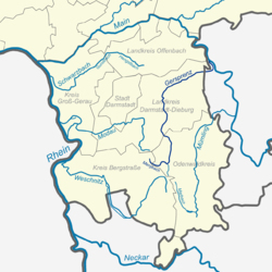
The list of rivers in the Gersprenz river system includes all direct and indirect tributaries of the Gersprenz , as far as they are named on the topographical map 1:25 000 Hessen (DK 25) , in the map of the city planning service of Euro-Cities AG or in the map service system of the Hessian State Office for Nature Conservation , Environment and Geology (HLNUG) WFD in Hesse . Other source works are documented separately in the individual references. Nameless inlets and branches are not taken into account. If the river name changes after the confluence of two river sections, the two tributaries are listed separately as source tributaries, otherwise the sub-area name appears in brackets. The length specifications are rounded to one decimal place. The rivers are listed downstream. The orographic directional information refers to the directly superior body of water.
Gersprenz
The Gersprenz is a 51.3 km (with Mergbach 62.2 km) long left tributary of the Main in Hesse .
Tributaries
- Direct and indirect tributaries of the Gersprenz
-
Mergbach ( left source stream ), 6.8 miles
- Zahlbach ( right ), 1.3 km
- Marbach ( right ), 2.1 km
- Bach an der Kniewiese ( left ), 1.4 km
-
Laudenauer Bach ( left ), 3.8 km
- Brook von dem Kohl ( right ), 1.6 km
- Benzenbach ( right ), 2.7 km
- Schnepfenbach ( right ), 0.8 km
- Beerbach ( left ), 1.1 km
- Eberbach ( left ), 4.6 km
- Osterbach ( right source stream ), 7.0 km
- Steinbach ( right ), 2.6 km
- Bach on the Margrund ( right ), 1.0 km
- Brook on the lake bottom ( left ), 1.5 km
- Bach von dem Vierstöck ( right ), 2.3 km
- Michelbach ( left ), 3.2 km
-
Crumbach ( Grumbach ) ( left ) 2.3 km (with brook at the Frohndelle 4.0 km)
- Stream at the Frohndelle ( right source stream ), 1.7 km
- Güttersbach ( left source stream ), 1.2 km
- Schleiersbach ( left ), 2.0 km
- Bach on the Schreinersgrund ( left ), 3.0 km
-
Kainsbach ( Stierbach ) ( right ), 3.8 miles
- Wünschbach ( right ), 1.8 km
- Stierbach ( right ), 1.8 km
- Affhöllerbach ( right ), 4.5 km
- Kilsbach ( right ), 1.8 km
- Bierbach ( left ), 1.8 miles
-
Brensbach ( right ), 5.2 km
-
Hollerbach ( right ), 2.0 km
- Höllerbach ( left ), 1.4 km
- Brook from the Rehwiesen ( left ), 1.5 km
- Matzbach (left), 1.3 km
- Hältersbach ( right ), 1.6 km
-
Hollerbach ( right ), 2.0 km
- Kühbach ( left ), 1.0 km
- Kohlbach ( right ), 2.3 km
-
Gräbenackersbach ( left ), 2.6 km
- Kirchbach ( right ), 2.7 km
- Brechelser Floß ( right ), 1.4 km
-
Fischbach ( left ), 9.7 km
-
Steinbach ( right ), 3.5 km
- Steinbach ( right ), 1.0 km
- Meßbach ( right ), 2.2 km
-
Nonroder Bach ( right ), 3.0 km
- Bach from the Jostkirche ( right ), 1.0 km
- Wolfsgraben ( right ), 1.2 km
- Stream from Eselsbrunnen ( left ), 1.0 km
-
Rodauer Bach ( Johannisbach ) ( left ), 8.4 km
- Lützelbach ( right ), 1.3 km
- Hottenbach ( right ), 2.8 km
-
Asbach ( left ), 2.5 km
- Brook from Donnerbockswiese ( left ), 1.7 km
- Bach von dem Nobkunz ( left ), 0.7 km
- Bierbach ( right ), 1.6 km
- Alte Bach ( left ), 1.3 km
- Flurbach ( left ), 1.3 km
-
Steinbach ( right ), 3.5 km
- Schaubach ( left ), 1.4 km
-
Landwehrgraben ( left ), 1.1 km
- Langer Graben ( right ), 2.8 km (with Wembach 10.7 km)
-
Wembach , 4.9 miles
- Hahner Bach ( left ), 2.2 km
-
Dilsbach ( left ), 7.4 km
- Litzelbach ( right ), 0.7 km
- Reifelbach ( left ), 1.2 km
- Bettenwiesengraben ( left ), 1.0 km
-
Hirschbach ( left ) 5.0 km (with Zeilharder Bach 7.5 km)
- Weihersgraben ( left ), 1.0 km (with Säugraben 2.2 km)
- Fellborngraben ( Ochsengraben ) ( left source stream ), 0.4 km
- Säugraben (right source stream), 1.2 km
- Zeilharder Bach ( right source brook ), 2.5 km
- Weihersgraben ( left ), 1.0 km (with Säugraben 2.2 km)
-
Erbesbach ( Erbsenbach , Riedsbach ) ( left ), 9.0 km
- Fischwasser ( Hinterwiesengraben ) ( left ), 6.3 km
- Fischwasser ( left ), 3.0 km
- Engelswiesengraben ( right ), 1.1 km
- Altstrutgraben ( right ) 0.7 km
- Collerswiesengraben ( left ), 1.2 km
- Engelswiesengraben ( right ), 1.1 km
- Fischwasser ( left ), 3.0 km
- Stickesgraben ( left ) 4.3 km
- Hehnesgraben ( right ), 1.5 miles
- Fischwasser ( Hinterwiesengraben ) ( left ), 6.3 km
-
Glaubersgraben ( Hermersgraben ) ( left ), 4.4 km
- Hermersgraben ( left ) 3.5 km
- Graben von der Fohlenweide ( left ), 4.7 km
- Erlenbach ( left ), 6.3 km
-
Semme ( Semder Bach ) ( right ), 20.5 km
- Hassenrother Bach ( left ), 1.8 km
- Beerbach (right), 2.5 km
- Brook from the Auwiese ( left ), 2.0 km
- Ditzenbach ( left ), 0.5 km
- Bach von der Aspe ( right ), 1.0 km
- Schweinsgraben-Sandgraben ( left ), 5.9 km
- Pigeon shirt ( right ), 4.4 km
- Banngraben ( left ), 2.2 km
-
Ohlebach ( right ) 2.0 km (with Richerbach 22.7 km)
- Richerbach ( left source stream ) 11.8 km (with horse creek 20.7 km)
- Pferdsbach ( left source stream ) 8.9 km
- Heubach ( left ), 1.0 km
- Hainborn ( right ), 0.1 km
- Wiebelsbach (Pferdsbach) ( left ), 3.8 km
- Wiebels-Bach ( left ), 1.6 km
- Brook from the Erlenstall ( left ), 1.3 km
- Molsbach ( left ), 1.2 km
- Eichgraben ( left ), 3.5 km
- Wächtersbach ( right source stream ), 3.5 km
- Raibach ( right ), 3.5 km
- Ohlbach ( right ), 1.4 km
- Amorbach ( right ), 6.3 km
- Flurgraben ( left ), 1.5 km
- Pferdsbach ( left source stream ) 8.9 km
- Länderbach ( right source stream ) 9.5 km
- Kleestädter Bach ( left ), 4.1 km
- Schlierbach (right), 3.1 km
- Richerbach ( left source stream ) 11.8 km (with horse creek 20.7 km)
-
Lache ( Neuer Graben ) ( left ), 9.4 miles
- Neuer Graben ( right ), 1.8 km
- Hegwaldbach (right), 8.3 km
- Romesbach ( left )
- Speckgraben ( left ), 1.1 km
Individual evidence
- ↑ a b is at WFD - probably wrongly - as the upper reaches of Hirschbach referred
- ↑ If, according to by locals as Hirschbach referred
- ↑ Name for the upper course
- ↑ Bleed designation in the city map service
- ↑ Also called a name from the middle reaches of the Ohlebaches viewed
- ↑ Also called a name from the upper reaches of the Ohlebaches viewed
- ↑ a b Also called a tributary of Ohlebaches viewed
