
Lache (Gersprenz)
| laugh | ||
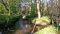
2.jpg) The pool just before it flows into the Gersprenz |
||
| Data | ||
| Water code | DE : 24768 | |
| location |
Rhine-Main lowlands
|
|
| River system | Rhine | |
| Drain over | Gersprenz → Main → Rhine → North Sea | |
| source | west of Eppertshausen 49 ° 56 '49 " N , 8 ° 47' 17" E |
|
| Source height | 171 m above sea level NHN | |
| muzzle | near Harreshausen in the Gersprenz Coordinates: 49 ° 58 '22 " N , 8 ° 58' 46" E 49 ° 58 '22 " N , 8 ° 58' 46" E |
|
| Mouth height | 125 m above sea level NHN | |
| Height difference | 46 m | |
| Bottom slope | 3 ‰ | |
| length | 15.4 km | |
 The pool (left) flows into the Gersprenz (right) |
||
The pool is a good 15 km long and left tributary of the Gersprenz in the districts of Offenbach and Darmstadt-Dieburg in Hesse .
geography
course
The pool rises in the Eppertshausen district west of the village on the edge of the Neuwiese von Messel nature reserve .
After a few hundred meters, it crosses the border to Rödermark in the Offenbach district and there passes under the federal highways 486 and 45 . To the north of Eppertshausen, the pool reaches the Darmstadt-Dieburg district again and runs eastward mainly in the forest. To the north of Hergershausen , part of the Gersprenz flowing further south is fed to it. If the Gersprenz is in high water, part of it can be fed into the pool via this junction.
Then the pool continues through Babenhausen . North of Harreshausen it flows into the Gersprenz .
The Gersprenzgebiet water association based in Erbach is now responsible for maintaining the pool.

Lache in the western area of the nature reserve " Brackenbruch bei Hergershausen "

Laugh in front of the joker arm inflow
Confluence of the Lache and the Gersprenzarm

Laugh after the influx of the sprinkler arm


Tributaries
- New trench (right)
- Hegwaldbach (right)
Gersprenz river system
Web links
Individual evidence
- ↑ OpenTopoMap
- ↑ Antiquity and history of the Bachgau in the old Maingau
- ↑ Main-Echo: Keyword: Gersprenz, Lache and Ohlebach