
Dilsbach
| Dilsbach | ||
 |
||
| Data | ||
| Water code | DE : 24763342 | |
| location |
Rhine-Main lowlands
|
|
| River system | Rhine | |
| Drain over | Gersprenz → Main → Rhine → North Sea | |
| source | east of Ober-Ramstadt | |
| muzzle | north-east of Reinheim - Spachbrücken in the Landwehrgraben Coordinates: 49 ° 51 ′ 7 " N , 8 ° 51 ′ 17" E 49 ° 51 ′ 7 " N , 8 ° 51 ′ 17" E
|
|
| length | approx. 7.4 km | |
The Dilsbach is an approximately seven and a half kilometers long left and western tributary of the Gersprenz .
geography
course

The upper reaches of the Dilsbach near Ober-Ramstadt - Panorama

The brook rises on the Habichtrech to the east of Ober-Ramstadt , flows through the hamlet of Dilshofen and Reinheim- Spachbrücken and merges north of the Reinheimer Teich nature reserve with the outflow of the pond and the Langen Graben (in the upper reaches of Wembach ) to form the Landwehrgraben , which after about one kilometer in the Gersprenz flows.
Tributaries
- Litzelbach ( right ), 0.7 km
- Reifelbach ( left ), 1.2 km
- Bettenwiesengraben ( left ), 1.0 km
Gersprenz river system
Biotope
The Reinheimer pond is a well-known nature reserve in which, among other things, the European pond turtle occurs.

Scottish highland cattle at the Reinheimer ponds , near the NABU location on the Dilsbach flowing by
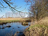
The Dilsbach at the Reinheimer pond

View of the Reinheim pond. Behind the barn the Dilsbach flows along the pond

The Reinheimer ponds in November 2011


