Michelbach (Gersprenz)
| Michelbach | ||
|
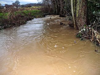
At high tide |
||
| Data | ||
| Water code | DE : 247615926 | |
| location | Hessen ; Germany | |
| River system | Rhine | |
| Drain over | Gersprenz → Main → Rhine → North Sea | |
| source | Wood near a four-sided farm in Michelbach 49 ° 43 '47 " N , 8 ° 50' 35" E |
|
| Source height | approx. 225 m above sea level NN | |
| muzzle | at the Schmalmühle Fränkisch-Crumbach coordinates: 49 ° 44 ′ 40 ″ N , 8 ° 52 ′ 19 ″ E 49 ° 44 ′ 40 ″ N , 8 ° 52 ′ 19 ″ E |
|
| Mouth height | approx. 180 m above sea level NN | |
| Height difference | approx. 45 m | |
| Bottom slope | approx. 14 ‰ | |
| length | approx 3.2 km | |
| Communities | Franconian Crumbach | |
The Michelbach is a good three kilometers long left and southwest tributary of the Gersprenz .
geography
course
The Michelbach rises in the Odenwald , south of Fränkisch-Crumbach on a wood near a four-sided farm on the southern edge of the district of Michelbach . The brook flows from the Hasenberg to the north, displaced by the hamlet-like settlement of Michelbach and flows into the left branch of the Gersprenz on the eastern edge of Fränkisch-Crumbach, about 450 meters south of the Schmalmühle .
