Knoden head
| Knoden head | ||
|---|---|---|
|
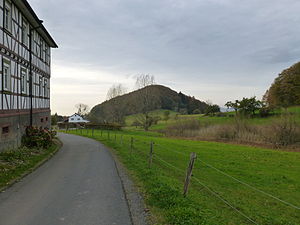
View from Knodener Kopfstraße in Knoden through the valley from the brook to the Rehklingen west-northwest to the Knodener Kopf |
||
| height | 511.2 m above sea level NHN | |
| location | at knots ; Bergstrasse District , Hesse ( Germany ) | |
| Mountains | Odenwald | |
| Dominance | 0.77 km → Knörsch Hill | |
| Notch height | 38 m | |
| Coordinates | 49 ° 41 '47 " N , 8 ° 42' 39" E | |
| Topo map | LAGIS Hessen . | |
|
|
||

The Knodener Kopf between Knoden and Reichenbach in the Bergstrasse district in southern Hesse is 511.2 m above sea level. NHN high and wooded mountain in the Odenwald .
geography
location
The Knodener Kopf rises in the Vorderen Odenwald in the Bergstrasse-Odenwald Nature Park in the Knoden district of the Lautertal community . Its summit is 2.1 km southeast of Reichenbach in the Lauter valley , the core town of the Lautertal community, between the districts of Breitenwiesen in the east-northeast and Knoden in the southeast and the Bensheim district of Gronau in the southwest. The next higher mountain, the Knörschhügel ( 536 m ), is just under 1000 m to the east . The Reichenbach rises on the northeast flank of the Knodener Kopf and flows into the Lauter in the center of Reichenbach, which is called Winkelbach from Bensheim and flows into the Rhine at Gernsheim .
Natural allocation
The Knodener Kopf belongs to the natural spatial main unit group Odenwald, Spessart and Südrhön (No. 14) and in the main unit Vorderer Odenwald (145) to the subunit Krehberg-Odenwald (145.5).
Summit area
On the summit of the Knodener Kopf there is a trigonometric point and a few meters south of it there is a historical trigonometric surveying stone.
Traffic and walking
From Gadernheim in the northeast of the Lautertal, take the county road 55 ( Krehbergstrasse ) past Breitenwiesen to Knoden . There, Knodener Kopfstraße , which runs along the stream to the Rehklingen , branches off to the west from this street . The Knoden hikers 'car park and two hikers' homes run by the Odenwald Club are in the village .
The Knodener Kopf is located on three main hiking trails of the Odenwald Club:
- the 130 km long quality hiking trail HW 72 Nibelungensteig from Zwingenberg an der Bergstrasse to Freudenberg am Main,
- the 84 km long HW 13 from Ober-Ramstadt to Wiesenbach and
- the 62 km long HW 20 from Bensheim to Miltenberg .
Individual evidence
- ↑ a b Map services of the Federal Agency for Nature Conservation ( information )
- ↑ Wanderheime on the website of the Odenwaldklubs eV
- ↑ Quality hiking trails - Nibelungensteig (HW 72) on the website of the Odenwaldklubs eV
- ↑ Hessian Land Surveying Office: topographical leisure map Nördlicher Odenwald West , M = 1: 50,000, 2009

