Wersau
|
Wersau
Brensbach municipality
|
|
|---|---|
| Coordinates: 49 ° 46 ′ 35 ″ N , 8 ° 51 ′ 48 ″ E | |
| Height : | 173 m above sea level NHN |
| Area : | 5.68 km² |
| Residents : | 1334 (Jun. 30, 2016) |
| Population density : | 235 inhabitants / km² |
| Incorporation : | August 1, 1972 |
| Postal code : | 64395 |
| Area code : | 06161 |

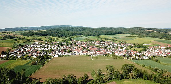
With about 1300 inhabitants, Wersau is the second largest district of the municipality of Brensbach in the Odenwald district in southern Hesse and is called Wersche by the residents in the dialect .
geography
location
Wersau is located in the north of the Odenwald in the Gersprenz lowlands on the left western bank of the river, diagonally across from the nearby core town of Brensbach on the other side of the Gersprenz. The highest point of the district is in the southwest on the 310 meter high foothills of a wooded ridge. In the south, the Bierbach largely forms the border with Fränkisch-Crumbach . On the north bank of the stream, Wersau has a share in the hamlet of Bierbach . The northern part of the district lies on the Kohlbach on the other side of the Gersprenz. There Wersau has two farmsteads in the hamlet of Hippelsbach on the border with Groß-Bieberau , which is also the district border with Darmstadt-Dieburg.
The district area is mainly used for agriculture. Geologically, Wersau belongs to the crystalline Vorderen Odenwald . Wersau is in the Starkenburg region and in the Bergstrasse-Odenwald Geo-Nature Park .

Waters
The following streams arise or run through the Wersau district and all drain in the Gersprenz:
- Bierbach
- Küh-Bach
- Moorbach
- Kirchbach
- Gräbenackersbach
- Kohlbach (the only one drained on the right (northeast) bank of the Gersprenz)
history
prehistory
A number of artefacts found in and around the place prove that people were present here even in the early days. A stone ax about 6,000 years old was found near the hamlet of Hippelsbach, and another stone ax was found in Wersau. In 1977 a menhir was discovered on the eastern edge of the district during field work , which was later moved 70 meters further to the border with Groß-Bieberau and is still there. The oldest evidence of settlement in what is now the local area are ceramic finds from Moorbachstrasse. The vessel fragments and a spindle whorl found here date from the Iron Age Laténe culture (between 450 BC and the birth of Christ).
Menhir von Wersau - prehistoric menhir
Spinning whorl and ceramic shards - Iron Age finds from Moorbachstrasse
Territorial history and courts
The place has been documented under the name “Wersauwe” since 1314 (from 1538 “Wersaw”, later “Wersau”). Wersau has had its own church since 1439, which was consecrated to Saint Egidius . The place belonged to a fourth each of the lordship of Breuberg and the principality of Löwenstein-Wertheim-Rochefort. The other half belonged to Hesse and was in the judicial district of the Zent Oberramstadt . The centering was divided into so-called "rice car," each of which a top magistrate board that the Zentgrafen were subordinated. This district had to provide a freight wagon ( rice wagon ) including draft animals and servants for campaigns. Wersau belonged to the "Großbieberauer Reiswagen", to which Waldhausen consists of the places Niedernhausen , Billings , Meßbach and Nonrod as well as the villages Rodau , Wersau and Steinau . The entire district of Oberramstadt was assigned to the Lichtenberg office . This classification existed until the beginning of the 19th century. In 1806 Wersau came completely to the Grand Duchy of Hesse .
As part of the regional reform in Hesse , Wersau was incorporated into the municipality of Brensbach on August 1, 1972 by state law at the same time as the municipalities of Höllerbach , Nieder-Kainsbach and Wallbach and moved from the district of Dieburg to the Odenwaldkreis. According to the main statute, a local district with a local advisory council and a local mayor was established for Wersau .
In 2014, the residents of Wersau and the surrounding area celebrated the 700th anniversary of the village.
The following list gives an overview of the territories in which Wersau was located and the administrative units to which it was subordinate:
Non-Hessian half:
- before 1805: Holy Roman Empire , (a quarter: Grafschaft Erbach-Schönberg, Herrschaft Breuberg ), (a quarter: Principality of Löwenstein-Wertheim-Rochefort , Cent Kirch-Brombach) (1805: shares of Löwenstein-Wertheim in Hesse through an exchange agreement)
Hessian half:
- before 1479: Holy Roman Empire, County of Katzenelnbogen , Upper County of Katzenelnbogen
- from 1479: Holy Roman Empire, Landgraviate of Hesse , Upper County of Katzenelnbogen
- from 1567: Holy Roman Empire, Landgraviate of Hessen-Darmstadt , Upper County of Katzenelnbogen, Lichtenberg Office , Oberramstadt district , Groß-Bieberauer Reiswagen
- from 1803: Holy Roman Empire, Landgraviate Hessen-Darmstadt, Principality of Starkenburg , Lichtenberg Office
Overall Hessian:
- from 1806: Grand Duchy of Hesse , Principality of Starkenburg, Lichtenberg Office
- from 1815: German Confederation , Grand Duchy of Hesse, Province of Starkenburg , Lichtenberg Office
- from 1821: German Confederation, Grand Duchy of Hesse, Starkenburg Province, Reinheim District District (separation between justice ( Lichtenberg District Court ) and administration)
- from 1832: German Confederation, Grand Duchy of Hesse, Province of Starkenburg, District of Dieburg
- from 1848: German Confederation, Grand Duchy of Hesse, Dieburg administrative region
- from 1852: German Confederation, Grand Duchy of Hesse, Province of Starkenburg, District of Dieburg
- from 1866: Grand Duchy of Hesse, Province of Starkenburg, District of Dieburg
- from 1871: German Empire , Grand Duchy of Hesse, Province of Starkenburg, District of Dieburg
- from 1918: German Empire, People's State of Hesse , Starkenburg Province, Dieburg District
- from 1938: German Empire, People's State of Hesse, District of Dieburg (In the course of the regional reform in 1938 , the three Hessian provinces of Starkenburg, Rheinhessen and Upper Hesse were dissolved.)
- from 1945: American zone of occupation , Greater Hesse , Darmstadt district, Dieburg district
- from 1949: Federal Republic of Germany , State of Hesse , Darmstadt district, Dieburg district
- on August 1, 1972 to the municipality of Brensbach and integration into the Odenwaldkreis
Dishes from 1803:
In the Landgraviate of Hesse-Darmstadt, the judicial system was reorganized in an executive order of December 9, 1803. The “Hofgericht Darmstadt” was set up as a court of second instance for the Principality of Starkenburg . The jurisdiction of the first instance was carried out by the offices or the landlords . The Lichtenberg Office was responsible for Wersau. The court court was the second instance court for normal civil disputes, and the first instance for civil family law cases and criminal cases. The superior court of appeal in Darmstadt was superordinate . The main courts had lost their function.
With the formation of the regional courts in the Grand Duchy of Hesse, the regional court of Lichtenberg was the court of first instance from 1821 . It followed:
- from 1848: Regional Court of Reinheim (relocated from Lichtenberg)
- from 1879: Reinheim District Court (renamed); second instance district court Darmstadt
- from 1968: Dieburg District Court with the dissolution of the Reinheim District Court; second instance district court Darmstadt
Emigration in the early 19th century
Until the 19th century there were many bad harvests in Europe due to the Little Ice Age . After many years of hardship, several families from Wersau and Bierbach emigrated to America. Most of them settled in the state of Illinois.
The 'Werscher Gäns'
At the end of the 19th and beginning of the 20th century, 260 Wersau geese were counted in Wersau, all of which ran unattended through the village and the fields, where they also caused damage to the harvest. That is why a goose herder was hired especially for these animals in 1913. His annual salary was 130 marks. That is why, in addition to the bell tower, the 'Werscher Gans' is a landmark of the village. (Source: history and stories of a village - 700 years of Wersau)
coat of arms
The Wersau coat of arms is designed as a speaking or speaking coat of arms (French poor parlantes). In heraldry, one describes such coats of arms that either allude to the name of the owner or a place or represent it like a vine. The coat of arms is divided vertically in the middle and shows a white goose on a green background on the right, underneath a white diagonal bar, on the left the Wersau church tower on a yellow background. The green side is (heraldically) on the right or in front, the yellow on the left or behind. The Wersau coat of arms is simple in execution and yet unusual for a local coat of arms, speaking five times. The green background in the right split shield is a reference to the designation of the earlier Gersprenzauen (goose pastures). The goose it contains stands for the Wersau villagers, who used to be and still are popularly known today as "Wersau geese". The oblique wave bar, which is also white in the green background (also silver in heraldry) represents the Gersprenz flowing past Wersau and closely connected to the place ). The yellow (in heraldry also gold) background in the left divided shield is a reference to the Wersau church tower, the symbol of Wersau. The structure of the church or steeple is usually strongly stylized in heraldry, differently in the Wersau coat of arms. There it is the exact representation of the free-standing bell tower (after: Gerhard Kirchner, Heraldiker, Reinheim).
Culture and sights
Buildings
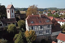
The Pfarrberg with the old rectory as the dominant building is one of the oldest parts of the village. This complex, together with the two large court riders at the bend in Schulstrasse , with the fortified fortified church and the old part of the cemetery, is a listed building as a whole. Not only the buildings are protected, but also the particularly completely preserved stone fences and the steep stairway between Schulstrasse and Pfarrberg, with a chestnut tree, which is designated as a natural monument. In addition to the Protestant church and the schoolhouse, six other properties in Wersau are protected, including the town's oldest half-timbered house from 1614.
See: List of cultural monuments in Wersau .
On the occasion of the 700th anniversary celebration in 2014, a historical place-name sign was installed in the center of Wersau with the representation of a circular route through the place, where information on their history can be found on glass panels at currently 26 objects steeped in history.
Goose fountain and goose stele
The Gänsebrunnen is located near the historical center of the village on Moorbachstrasse. It is also called "Schebbbrunne" or "Milschkisch" by the people of Wersau, because a well was installed there earlier and the central milk collection point was previously located. The well was installed as part of the village renewal. The goose stele is in the center of the village right next to the sign and was set up as part of the 700th anniversary celebration in 2014.
societies
- Rifle Club 1970 Wersau e. V.
- Shooting Community Gersprenztal eV Member of the Association of German Sport Shooters based in Wersau and shooting disciplines of the BDS
- Gymnastics Club TV 1908 Wersau
- Weight training club KSV 1920 Wersau
- Mixed choir (previously MGV 1892) Wersau
- Wersau volunteer fire department
- Small animal breeding association Wersau
- Social association VdK Hessen-Thuringia local association Wersau
- Wersche Party Crew
- Notch club Wersau
- Local history and history association Wersau
- Music Academy Gersprenztal Werkkunstschule e. V.
- Odenwaldverein Wersau
- Wersau Hunting Association
Economy and Infrastructure
Education and care
primary school
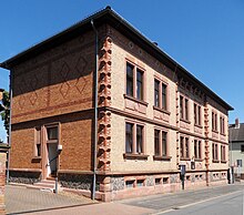
The primary school is located on Schulstrasse, in the immediate vicinity of the fire station and is housed in a listed brick building from 1892.
The primary school in Wersau accommodates grades 1 - 4 for around 60 pupils.
kindergarten
The Wersau kindergarten with around 60 childcare places is housed in the extension of the village community center and is called "Treasure Island".
traffic
The district road K 74 runs through the village in a north-south direction and connects Wersau in both directions with the nearby federal road 38 . At the northern connection, the state road L 3065 continues as an extension of the K 74 northwards towards Otzberg .
Wersau was connected to the Reinheim-Reichelsheimer railway line from October 10, 1887 to May 25, 1963 with a stop at the “Zum Kühlen Grund” inn .
Personalities related to Wersau
- Peter Made (1775–1853), Zentschultheiß von Wersau and member of the 2nd Chamber of the Estates of the Grand Duchy of Hesse
- Timo Glock (* 1982), automobile racing driver, grew up here
- Reinhard Bock, two-time German junior wrestling champion and 1966 member of the German national team
literature
- History and stories of a village. 700 years of Wersau . Local history and history association 700 years of Wersau, 2014, ISBN 978-3-00-044571-2 .
- Karl Eidenmüller: Family book Wersau / Odenwald with Bierbach 1640–1807 . (= Writings of the Hessian Family Studies Association. No. 10). 1992.
- Kurt Schnellbächer: The history of the school in the village of Wersau . ( online as pdf )
- Literature about Wersau in the Hessian Bibliography
- All entries on Wersau in the catalog of the German National Library
Web links
- Wersau district on the website of the municipality of Brensbach.
- Wersau, Odenwaldkreis. Historical local dictionary for Hessen. In: Landesgeschichtliches Informationssystem Hessen (LAGIS).
- Entry on Wersau at genealogy.net
Individual evidence
- ↑ a b Wersau, Odenwaldkreis. Historical local dictionary for Hessen. (As of October 16, 2018). In: Landesgeschichtliches Informationssystem Hessen (LAGIS).
- ↑ Wersau on the website of the municipality of Brensbach , accessed in August 2016
- ↑ Source: History and stories of a village - 700 years of Wersau
- ↑ Is Wersau over 2000 years old? In: www.hugv-wersau.de. Local history and history association Wersau, accessed in January 2020 .
- ^ Online local family book Wersau .
- ↑ Hessen-Darmstadt state and address calendar 1791 . In the publishing house of the Invaliden-Anstalt, Darmstadt 1791, p. 123 ( online at HathiTrust's digital library ).
- ^ Wilhelm Müller: Hessian place names book: Starkenburg . Ed .: Historical Commission for the People's State of Hesse. tape 1 . Self-published, Darmstadt 1937, DNB 366995820 , OCLC 614375103 , p. 727 .
- ^ Ferdinand Dieffenbach: The Grand Duchy of Hesse in the past and present . Literary Institution, Darmstadt 1877, p. 254 ( online at google books ).
- ↑ Law on the reorganization of the district of Erbach (GVBl. II 330–16) of July 11, 1972 . In: The Hessian Minister of the Interior (ed.): Law and Ordinance Gazette for the State of Hesse . 1972 No. 17 , p. 224 , § 8 ( online at the information system of the Hessian state parliament [PDF; 1,2 MB ]).
- ^ Federal Statistical Office (ed.): Historical municipality directory for the Federal Republic of Germany. Name, border and key number changes in municipalities, counties and administrative districts from May 27, 1970 to December 31, 1982 . W. Kohlhammer GmbH, Stuttgart and Mainz 1983, ISBN 3-17-003263-1 , p. 359 .
- ↑ Main statute § 5. (PDF; 50 KB) Municipality of Brensbach, accessed in May 2019 .
- ↑ Gersprenztal advertising paper: 700 years of Wersau ( memento of October 26, 2014 in the Internet Archive ), accessed on June 27, 2014.
- ^ Michael Rademacher: German administrative history from the unification of the empire in 1871 to the reunification in 1990. State of Hesse. (Online material for the dissertation, Osnabrück 2006).
- ^ Grand Ducal Central Office for State Statistics (ed.): Contributions to the statistics of the Grand Duchy of Hesse . tape 1 . Darmstadt 1866, p. 43 ff . ( online at Google Books ).
- ↑ State Office for the Preservation of Monuments in Hesse (ed.): Entire complex Wersau In: DenkXweb, online edition of cultural monuments in Hesse
- ↑ Wersau local history and history association. Website.


