
Darsberg
|
Darsberg
City of Neckarsteinach
Coordinates: 49 ° 25 ′ 5 ″ N , 8 ° 51 ′ 7 ″ E
|
|
|---|---|
| Height : | 309 m above sea level NHN |
| Area : | 2.43 km² |
| Residents : | 513 (May 9, 2011) |
| Population density : | 211 inhabitants / km² |
| Incorporation : | 1st October 1971 |
| Postal code : | 69239 |
| Area code : | 06229 |
 View over Darsberg
|
|
Darsberg is a village with over 500 inhabitants and a district of Neckarsteinach in the Bergstrasse district in southern Hesse .
Geographical location

Darsberg is located in the southernmost tip of Hesse near the Neckar valley about two kilometers northeast of the core town of Neckarsteinach in the southern Odenwald at an altitude of about 350 meters. The district road K 38 from Neckarsteinach to the district Grein leads through Darsberg.
history
Darsberg is mentioned for the first time in a document from 1174 as Tagersperch . At that time, the bishops of Worms gave the place as a fief to the Landschad von Steinach and the knights of Hirschhorn . However, 1329 is the founding year of the village, since this year the village of Darsperg is expressly mentioned for the first time in a fiefdom letter from Gerlach von Worms to knight Hans von Hirschhorn . Darsberg and Neckarsteinach once shared a common area.
The Sebastian Chapel was built in the second half of the 15th century . At that time, Darsberg was important for the Neckarsteinach lords because their only way into the hinterland was through the village. In the Thirty Years' War , the Palatinate War of Succession , the Spanish War of Succession and the Coalition Wars , Darsberg was affected.
After the noble von Steinach family died out in 1653, Darsberg changed hands several times: in the meantime it belonged to the Electoral Palatinate , Baden and Hesse, then again to the monasteries of Worms and Speyer . In the Reichsdeputationshauptschluss of 1803, the place then finally came to Hesse in the course of mediatization .
The statistical-topographical-historical description of the Grand Duchy of Hesse reports on Darsberg in 1829:
»Darsberg (L. Bez. Hirschhorn); evangl. protest. and cath. Branch village; is located on the Ulvenbach, 1 St, from Hirschhorn and has 1 small church, 26 houses and 218 inhabitants; among which there are 177 evangelicals. prot. and 41 cath. are located. In 1628 the Lords of Hirschhorn still owned serfs here. The village, which formerly belonged to the knightly canton of Odenwald, came from Mainz to Hesse in 1802. «
In Hesse, the affiliation to counties and districts changed several times before Darsberg was incorporated into the Bergstrasse district in 1938. In the course of the regional reform in Hesse , the previously independent community of Darsberg was incorporated into the city of Neckarsteinach on October 1, 1971 on a voluntary basis. For Darsberg and for the other municipalities incorporated into Neckarsteinach, local districts with local advisory councils and local heads were formed according to the Hessian municipal code.
Territorial history and administration
The following list gives an overview of the territories in which Darsberg was located and the administrative units to which it was subordinate:
- before 1803: Holy Roman Empire , ( Prince Bishopric Worms , Office Neckar-Steinach and Prince Bishopric Speyer , Office Grombach) half each
- from 1803: Holy Roman Empire, Landgraviate of Hesse-Darmstadt (through Reichsdeputationshauptschluss ), Principality of Starkenburg , Office Neckar-Steinach
- from 1806: Grand Duchy of Hesse , Principality of Starkenburg, Office of Neckar-Steinach
- 1812: Grand Duchy of Hesse, Principality of Starkenburg, Hirschhorn Office
- from 1815: German Confederation , Grand Duchy of Hesse, Province of Starkenburg , Hirschhorn Office
- from 1821: German Confederation, Grand Duchy of Hesse, Starkenburg Province, Hirschhorn district (separation between justice ( Hirschhorn district court ) and administration)
- from 1832: German Confederation, Grand Duchy of Hesse, Starkenburg Province, Bensheim district
- from 1840: German Confederation, Grand Duchy of Hesse, Province of Starkenburg, District of Heppenheim
- from 1848: German Confederation, Grand Duchy of Hesse, administrative district of Heppenheim
- from 1852: German Confederation, Grand Duchy of Hesse, Starkenburg Province, Lindenfels District
- from 1865: German Confederation, Grand Duchy of Hesse, Province of Starkenburg, District of Heppenheim
- from 1867: Grand Duchy of Hesse, Province of Starkenburg, District of Heppenheim
- from 1871: German Empire , Grand Duchy of Hesse, Province of Starkenburg, District of Heppenheim
- from 1918: German Empire, People's State of Hesse , Starkenburg Province, Heppenheim District
- from 1938: German Empire, People's State of Hesse , Bergstrasse district (In the course of the regional reform in 1938 , the three Hessian provinces of Starkenburg, Rheinhessen and Upper Hesse are dissolved.)
- from 1945: American zone of occupation , Greater Hesse , Darmstadt administrative district, Bergstrasse district
- from 1949: Federal Republic of Germany , State of Hesse , Darmstadt district, Bergstrasse district
- on October 1, 1971 to the city of Neckarsteinach
Population development
| • 1806: | 174 inhabitants, 24 houses |
| • 1829: | 218 inhabitants, 26 houses |
| • 1867: | 238 inhabitants, 32 houses |
| Darsberg: Population from 1806 to 2011 | ||||
|---|---|---|---|---|
| year | Residents | |||
| 1806 | 174 | |||
| 1829 | 218 | |||
| 1834 | 209 | |||
| 1840 | 234 | |||
| 1846 | 250 | |||
| 1852 | 262 | |||
| 1858 | 264 | |||
| 1864 | 247 | |||
| 1871 | 251 | |||
| 1875 | 252 | |||
| 1885 | 255 | |||
| 1895 | 262 | |||
| 1905 | 266 | |||
| 1910 | 260 | |||
| 1925 | 292 | |||
| 1939 | 255 | |||
| 1946 | 361 | |||
| 1950 | 376 | |||
| 1956 | 381 | |||
| 1961 | 439 | |||
| 1967 | 448 | |||
| 1970 | 445 | |||
| 1980 | ? | |||
| 1990 | ? | |||
| 2002 | 548 | |||
| 2010 | 549 | |||
| 2011 | 513 | |||
| Data source: Historical municipality register for Hesse: The population of the municipalities from 1834 to 1967. Wiesbaden: Hessisches Statistisches Landesamt, 1968. Further sources: up to 1970 :; 2002 , 2010 from web archive; 2011 census | ||||
Religious affiliation
| • 1829: | 177 Protestant prostheticians (= 81.19%) and 41 Catholic (= 18.81%) residents |
| • 1961: | 277 Protestant (= 63.10%), 124 Catholic (= 28.25%) residents |
politics
There is a local district for Darsberg (areas of the former municipality of Darsberg) with a local advisory board and local councilor according to the Hessian municipal code . The local advisory board consists of seven members. Mayor is Holger Ludwig.
Culture and sights
Buildings
The Sebastian Chapel in Darsberg is a late Gothic building from the 15th century. An old stone cross is set into a wall on the village square near the Sebastian Chapel. At the old school house there is a historical coat of arms stone.
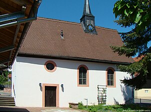
Sebastian Chapel

Old school house
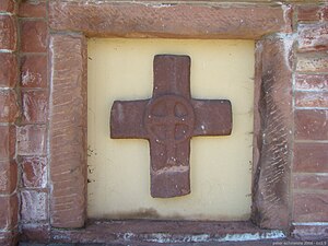
Stone cross on the village square
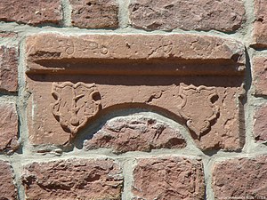
Wappenstein at the old school house


Regular events
The traditional Odenwald customs that are cultivated for Carnival attracts visitors from the wider area every year. In Darsberg there is a procession of carnival witches to Guggenmusik , after which a fire wheel is rolled down into the valley. Depending on the weather, around 1000 visitors come to Darsberg for Mardi Gras.
Individual evidence
- ↑ a b c d Darsberg, Bergstrasse district. Historical local dictionary for Hessen. (As of October 16, 2018). In: Landesgeschichtliches Informationssystem Hessen (LAGIS).
- ↑ a b Selected data on population and households on May 9, 2011 in the Hessian municipalities and parts of the municipality. (PDF; 1.8 MB) In: 2011 Census . Hessian State Statistical Office
- ↑ Walther Möller and Karl Krauß: Neckarsteinach - his lords, the city and the castles (Starkenburg in his past, vol. 4), Mainz 1928, p. 69
- ^ A b c Georg Wilhelm Justin Wagner : Statistical-topographical-historical description of the Grand Duchy of Hesse: Province of Starkenburg . tape 1 . Carl Wilhelm Leske, Darmstadt October 1829, OCLC 312528080 , p. 44 ( online at google books ).
- ↑ 175 years of BA - 175 headlines. (PDF; 9.0 MB) The creation of the Bergstrasse district. In: Morgenweb. Bergsträßer Anzeiger, 2007, p. 109 , archived from the original on December 20, 2014 ; Retrieved February 9, 2015 .
- ^ Federal Statistical Office (ed.): Historical municipality directory for the Federal Republic of Germany. Name, border and key number changes in municipalities, counties and administrative districts from May 27, 1970 to December 31, 1982 . W. Kohlhammer, Stuttgart / Mainz 1983, ISBN 3-17-003263-1 , p. 348 .
- ↑ a b main statute. (PDF; 177 kB) § 5. In: Website. City of Neckarsteinach, accessed October 2019 .
- ^ Michael Rademacher: German administrative history from the unification of the empire in 1871 to the reunification in 1990. State of Hesse. (Online material for the dissertation, Osnabrück 2006).
- ^ Grand Ducal Central Office for State Statistics (ed.): Contributions to the statistics of the Grand Duchy of Hesse . tape 1 . Großherzoglicher Staatsverlag, Darmstadt 1862, DNB 013163434 , OCLC 894925483 , p. 43 ff . ( Online at google books ).
- ↑ a b List of offices, places, houses, population. (1806) HStAD inventory E 8 A No. 352/4. In: Archive Information System Hessen (Arcinsys Hessen), as of February 6, 1806.
- ↑ See: Konrad Dahl: Historical-topographical-statistical description of the principality of Lorsch, or church history of the Oberrheingau . 1812, p. 276. Digitized .
- ^ Ph. AF Walther : Alphabetical index of the residential places in the Grand Duchy of Hesse . G. Jonghaus, Darmstadt 1869, OCLC 162355422 , p. 20 ( online at google books ).
- ^ Darsberg local advisory board. In: website. City of Neckarsteinach, accessed December 2019 .
- ↑ The fire wheel and the witch's procession - Carnival customs in Darsberg. In: www.darsberg.com. Private website, accessed October 2019 .
Web links
- Districts of Neckarsteinach. In: Website of the city of Neckarsteinach.
- Darsberg. Local history, information. In: www.darsberg.com. Private website
- Darsberg, Bergstrasse district. Historical local dictionary for Hessen. In: Landesgeschichtliches Informationssystem Hessen (LAGIS).
- Literature on Darsberg in the Hessian Bibliography