Parpaner Rothorn
| Parpaner Rothorn | ||
|---|---|---|
|
Heidsee and Rothorn |
||
| height | 2899 m above sea level M. | |
| location | Canton of Graubünden ( Switzerland ) | |
| Mountains | Alps | |
| Dominance | 0.75 km → Aroser Rothorn | |
| Notch height | 70 m ↓ ridge between Parpaner Rothorn and Aroser Rothorn | |
| Coordinates | 765 427 / 179156 | |
|
|
||
| Development | Cable car | |
The Parpaner Rothorn 2899 m above sea level. M. is an ore-rich mountain on the Lenzerheide in the Swiss canton of Graubünden . It is divided into the higher and unspoilt eastern summit and a 2865 m above sea level. M. high west summit, accessible by cable cars from Lenzerheide. The two peaks are about half a kilometer apart.
Location and surroundings
The Parpaner Rothorn is located in the Plessuralpen and is only about one kilometer from the highest peak, the Aroser Rothorn , with which the eastern summit is connected via a ridge with tracks. The east summit belongs to the municipalities of Lantsch / Lenz and Arosa , the west summit also belongs to Vaz / Obervaz . However, this naming is doubtful; so the official map series of Swisstopo only designates the western summit as Parpaner Rothorn, while the eastern summit , which is not directed against Parpan , bears no name and is called Mittler Rothorn or Mittelrothorn in Arosa and Schanfigg .
Tourist development
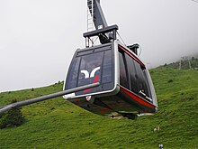
From the Rothornbahn valley station on the Heidsee , a gondola lift from Lenzerheide Bergbahnen, which was renewed in 2010, leads to the Scharmoin middle station ( 1905 m ), where another cable car leads to the western summit of the Rothorn (position 46 ° 45 ′ N , 9 ° 36 ′ E ). In 2015 the electrical control and the cabins were renewed. The mountain station does not have a fresh water pipe, which is why the water is transported up with the cable car.
The Rothornbahn was built in 1963 after the community of Arosa, as the landowner, issued a building permit to build the mountain station. In order to connect the new ski area on the Totälpli with the Lenzerheidner main area "Rothorn", approval was also obtained for the construction of a gallery through the east wall of the summit 2762 to Gredigs Fürggli at the southwestern foot of the Parpaner Weisshorn .
The Totälpli chairlift , which was also built in 1976 in the municipality of Arosa and leading from the north to the west summit , was dismantled in 2008. The Rothorn is accessible from several sides by hiking trails and from Scharmoin via the Goldgräberweg ( grade T2 ) and has been the highest point of the Arosa Lenzerheide ski arena since winter 2013/14 .
Special
From a geological point of view, the upper reddish part of the Rothorn consists of edge rock from the African plate, which has pushed over that of the ocean. Early forms of ore mining on the Rothorn have been documented as early as the Roman times. According to legend, there were precious metal mines (gold) on the Rothorn, which were still worked in the 17th century.
Due to the geographically favorable location, a mobile radio transmission system ( GSM ) with medium power is installed on the west summit . In autumn 2011, the Swiss Army installed a 34-meter-high receiving antenna with listening devices and a directional radio antenna not far from the cable car station. Because of its striking appearance, the vernacular in the Vaz / Obervaz – Lenz area now calls the construction the " minaret ".
The Swiss Irontrail , which was held for the first time in July 2012, was supposed to lead from Lenzerheide to Parpaner Rothorn, from there via Gredigs Fürggli to Arosa and on via Weisshorn and Carmenna towards Ausserschanfigg . Since a route change in 2013, the Parpaner Rothorn is no longer part of this sporting event.
swell
- Hans Danuser : Arosa place and field names with inclusion of the Welschtobel and some border areas of neighboring communities, self-published Danuser, Arosa 2011, ISBN 3-905342-49-9 , pp. 74, 79, 100.
- Manfred Hunziker: Ringelspitz / Arosa / Rätikon, Alpine Touren / Bündner Alpen , Verlag des SAC 2010, ISBN 978-3-85902-313-0 , p. 310.
Individual evidence
- ↑ Hans Danuser: Aroser place names and field names , self-published, Arosa 2011, ISBN 3-905342-49-9 , pp. 74, 79, 100.
- ↑ Swiss television DRS, Science Suisse broadcast, Prof. Dr. Adrian Pfiffner, April 12, 2009
- ↑ Source: Federal Office of Communication , (effective radiated power between 100 and 1000 W), as of December 2006
- ↑ Aroser Zeitung of May 24, 2013, p. 11.


