
Plessur Alps
| Plessur Alps | |
|---|---|
 |
|
 |
|
| Highest peak | Aroser Rothorn ( 2980 m above sea level ) |
| location | Graubünden / Switzerland |
| Classification according to |
AVE : 63 SOIUSA : 15.VII |
| Coordinates | 767 454 / 178 872 |
The Plessur Alps (occasionally also Plessurgebirge or Plessur for short ) are a mountain group in the Swiss canton of Graubünden . The highest peak is the Aroser Rothorn ( 2980 m above sea level ).
The group is divided into two by the river Plessur . In the middle of the mountains lies the health resort of Arosa with the Welschtobel and the valley communities of Schanfigg , Urdental , Fondei and Sapün , with holiday resorts such as Klosters , Davos or Lenzerheide around it .
location
The Plessur Alps are assigned to the western Eastern Alps and in a central location border directly on the western Alps . According to the Alpine Club division of the Eastern Alps (AVE), the group is limited as follows:
- in the northwest of the Rhine . This forms the border of the AVE division of the Eastern Alps . On the other bank is the Calandastock of the Glarus Alps
- The Prättigau ( Landquart ) forms the border to the Rätikon in the northeast
- from Klosters to Davos there is a small stretch of the Silvretta
- in the southeast of the group of the is Albula Alps through the barrel of the land water and the Albula to Tiefencastel separated
- in the southwest of the Oberhalbsteiner Alps through Albula and Hinterrhein
The name goes back to the Swiss geologist Bernhard Studer , who described it as an "almost pre-alpine department" within the Rhaetian Alps .
Outline and major summits
The Plessur Alps comprise several chains:
- the Parpaner-Rothorn / Lenzer Horn chain : Here are the highest mountains in the group, next to the Arosa Rothorn, the Erzhorn ( 2924 m ), the Lenzer Horn and the Parpaner Rothorn . The latter, like Hörnli , Weissflue and Weisshorn, is served by a gondola lift.
- the Stätzerhorn chain with the Stätzerhorn ( 2574 m ) as the highest point
- the Hochwang chain ( Hochwang 2534 m )
- the Weissfluegruppe with the Weissflue ( 2844 m )
- the Weisshorn chain with the Weisshorn ( 2653 m )
- the elongated Strela chain with the Guggernell ridge ( 2810 m ) as the highest point. Because of its gray color, the north-western row of this mountain range, together with the Schafrügg - Erzhorn line, is also known as the Arosa Dolomites and is made up of impressive cones of rubble.
landscape
The eponymous Plessur rises in the middle of the Plessurgebirge, which then winds through the Schanfigg and flows into the Rhine near Chur .
photos

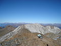
View from the Aroser Rothorn to the northeast (Arosa)
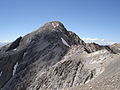
The Aroser Rothorn, highest mountain in the Plessur Alps

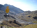
The Welschtobel , direction Fondei and Sapün seen
Geological contrasts with a view of Parpaner Weisshorn and Tschirpen
View from the Hörnlihütte to the Urdenfürggli

On the Sandhubel , view of the Altein Tiefenberg


Individual evidence
- ↑ Alpine association division of the Eastern Alps
- ↑ plural pen . In: Meyers Konversations-Lexikon . 4th edition. Volume 13, Verlag des Bibliographisches Institut, Leipzig / Vienna 1885–1892, p. 132.
literature
- Manfred Hunziker: Ringelspitz / Arosa / Rätikon, Alpine Touren / Bündner Alpen , Verlag des SAC 2010, ISBN 978-3-85902-313-0 , p. 264 ff.
- Henry Hoek and F. Siegried: The central Plessurgebirge . In: Yearbook of the Swiss Alpine Club. Vol. 38, 1902-03, pages 127-151
