
Erzhorn
| Erzhorn | ||
|---|---|---|
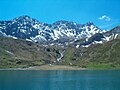
 Erzhorn with Aroser Rothorn (right) |
||
| height | 2924 m above sea level M. | |
| location | Canton of Graubünden ( Switzerland ) | |
| Mountains | Plessur Alps | |
| Dominance | 1.23 km → Aroser Rothorn | |
| Notch height | 180 m ↓ Erzhornsattel | |
| Coordinates | 767 505 / 179.14 thousand | |
|
||
| rock | dolomite | |
| Age of the rock | approx. 210 million years | |
| First ascent | unknown | |
| Development | Alpine Route (to Erzhornsattel) | |

The Erzhorn is 2924 m to the neighboring Arosa Rothorn is the second highest mountain in the Plessur Alps in the canton of Grisons in Switzerland . At the same time it is the westernmost and highest of a series of similarly built dolomite peaks in the northeast running ridge that connects the Aroser Rothorn with the Schafrügg . It stands on the border of the municipalities of Arosa and Albula / Alvra .
Location and description
The Erzhorn lies between the Arosa Schafälpli and the Welschtobel . At the summit, a ridge branches off from the aforementioned main ridge towards the southeast, which runs to Piz Culmet and ends at the Ramozhütte SAC. A little more pronounced and very difficult to walk north ridge drops steeply to the ore floors above the Plessur . The west ridge connects the summit with the Erzhornsattel. The direct ascent of the difficult north face was first achieved on April 16, 1902, Lieutenant Hereditary Count Waldbott von Bassenheim together with the chamois hunter Andreas Rüedi.
While the neighboring Aroser Rothorn, 1.4 km to the southwest, consists of crystalline elements of the Silvretta Nappe, the Erzhorn is the southwestern end of the Arosa Dolomites Nappe, which is the main thrust of the Eastern Alpine over the Penninic units and lies directly above the Arosa scale zone and extends in a north-easterly direction to the Chüpfenfluh on the Strela Pass .
From the summit, the visitor can enjoy a very good view, especially towards the Älplisee-Arosertal. Due to its double-peaked shape, clearly visible from Arosa, the Erzhorn is (unofficially) the heraldic mountain of the municipality of Arosa.
As its name suggests, like on the Rothörnern, Guggernellgrat and Tschirpen, also on the Erzhorn in the Middle Ages, iron ore and other mineral resources were mined and smelted in the smelting furnaces in the Isel near Arosa.
The legend of the Wunschhöhle near Arosa is at home near the Erzhorn .
Routes to the summit

Over the west ridge
- Starting points: Erzhornsattel ( 2744 m ), Ramozhütte ( 2293 m )
- Route: From Innerarosa in 3.5 hours via Schwelli and Älplisee through the northern flank ( T4 ) or from the Ramozhütte through the Erzhorntälli T3 to the Erzhornsattel. From there along the ridge to the summit
- Difficulty: T5
- Time required: 0.75 hours, 2.25 hours from the Ramozhütte
- Special: Most-traveled route with clear traces of use
Over the southeast ridge
- Starting points: Ramozhütte, Piz Culmet ( 2652 m )
- Route: On the alpine trail towards the Erzhornsattel. You reach the southeast ridge north of Piz Culmet via scree and grass. You follow the ridge over scree and rocks
- Difficulty: T5
- Time required: 2 hours, 1.25 hours from Piz Culmet
- Special: Alternative to the normal route, allows crossing the southeast ridge-west ridge
Crossing Schafrügg – Erzhorn
- Starting point: Arosa or Schafrügg
- Route: Over the ridge via Schaftällihorn, Älpliseehorn and Gamschtällihorn to the Erzhorn
- Difficulty: T6
- Time required: 9 hours from Arosa, 6.5 hours from Schafrügg
- Special: The Schafrügg – Erzhorn route is more recommendable as the opposite direction. You can descend into the Welschtobel from any saddle between two peaks
gallery
Erzhorn (right) with Gamschtällihorn and Älpliseehorn via Plessur and Schwellisee

Erzhorn with the northeast ridge of the Arosa Rothorn

View from the Aroser Rothorn to the Erzhorn (right)

Rothorn Group with Erzhorn (middle left)


swell
- Manfred Hunziker: Ringelspitz / Arosa / Rätikon, Alpineouren / Bündner Alpen , Verlag des SAC 2010, ISBN 978-3-85902-313-0 , p. 319 ff., 325 f.
- SAC Clubführer, Bündner Alpen 1, Tamina and Plessur Mountains , SAC publishing house, 4th edition 1988, p. 31, 325 f.
- Hans Danuser : Arosa - as it was then (1850–1907) , vol. 1, self-published by Danuser, Arosa 1997, p. 163.
- Hans Danuser, Ruedi Homberger: Arosa und das Schanfigg , self-published by Danuser / Homberger, Arosa 1988, p. 173 f.